Download
1 / 58
580 likes | 715 Views
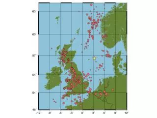
(from Fejerskov and Lindholm, 2000). EKOFISK EVENT Source parameters* of the earthquake of May 7, 2001 at 09:43 (UTC). Date: 07.05.2001 Time: 09:43:34,8 (UTC/GMT), 11:43 (Local) Location: 56 o 32’76N(56.546) and 3 o 11’82E(3.197) Location error (rms:0.7sec) is 3.9km E-W and 2.8km N-S

E N D
EKOFISK EVENT Source parameters* of the earthquake of May 7, 2001 at 09:43 (UTC) Date: 07.05.2001 Time: 09:43:34,8 (UTC/GMT), 11:43 (Local) Location: 56o32’76N(56.546) and 3o11’82E(3.197) Location error (rms:0.7sec) is 3.9km E-W and 2.8km N-S Depth: 3-7 km, 7-15 km, or <3 km Magnitude: 5.2 (MW), 5.0 (MS), 5.0 (mb) Energy: 2 x 10¹⁹ ergs Macroseismic intensity: VI (MMI/EMS98) Focal mechanism: Normal faulting Seismic Moment (MO): 5.94 x 10²³ dyne-cm First nodal plane: Strike 356o Dip 85o Rake –92o Second nodal plane: Strike 201o Dip 5o Rake –64o Focal mechanism is based on Moment Tensor Inversion Approximate fault length: 0.8-1.0 km (W&C), 2.5 km (K) * Parameters given above are as of 3 July 2001 and may be subject to change.
Structural Framework Map of the North Sea Basement Faults and the location of the 07.05.2001 earthquake Epicenter of 7th May Earthquake - estimated uncertainty ellipse elongated in Northwest - Southeast direction Tor Ekofisk
Rotliengendes TWT Structure Map Tor Albuskjell W. Ekofisk Ekofisk Edda Eldfisk Embla Fig. nr
Epicenter of 7th May Earthquake - estimated uncertainty ellipse elongated in Northwest - Southeast direction Tor Ekofisk Structural Framework Map of the North Sea Basement Faults The earthquake is most likely associated with movements of the hanging wall block of the indicated major fault. Since the Tor field installation is on the foot wall side less movement should occur. The strongest impact should be at the Ekofisk Complex which is closest to the epicenter on the hanging wall. Weaker impact should be felt on Eldfisk and Albuskjell due to their greater distance to the epicenter. All the observations on the platforms support these conclusions and this interpretation of the event.
6km Error ellipse as of 22 May 2001
3.9km Error ellipse as of 18 June 2001
6km Error ellipse as of 22 May 2001 3.9km Error ellipse as of 18 June 2001
Earthquake May 7 Epicenter Calculations from Different Agencies Hypocenter Annotated Norsar, 0 km fixed BGS, Shallow 1st Loc University In Bergen, 0 km fixed Final University In Bergen, 15 km University of Texas,, 29 km
Earthquake May 7 Epicenter Calculations from Different Agencies Hypocenter Annotated Norsar, 0 km fixed BGS, Shallow Final University of Bergen, 15 km 1st Loc University of Bergen, 0 km fixed University of Texas, 29 km
Date 07.05.2001; Time 09:43:34Loc. 56.565 N / 3.182; RMS=1.1; Mb=4.4; MS=4.6
Strike: 356Dip: 85Rake: -92 Mw: 5.1
GPS Analysis • Precise Point Positioning • using precise orbits, earth orientation parameters (EOP) and satellite clock corrections • Rapid Point Positioning • using rapid orbits, EOP and satellite clock corrections • High resolution GPS Time Series (30 seconds coordinate estimation) for 2/4 Hotel and 2/4 Alpha • stochastic station coordinates estimation (random walk) • Using precise orbits, clocks and EOP • Daily coordinate estimation • solving the station coordinates as constant parameters. • Precise point positioning (1 April - 02 June 2001) (DOY 91-153) • Rapid point positioning (03 June - 06 June 2001) (DOY 154-157)
Results • A weighted mean coordinate is computed using data from April 2001. • The figures plot the repeatability in north (latitude), east (longitude) and height, that is, the day to day scatter around these weighted mean coordinates for each platform.
Earthquake • The figures show three movements on 2/4 Hotel before the seismic event that was recorded by the seismograph stations of the NNSN • at 8:34 UTC/GMT • at 9:11 UTC/GMT • at 9:39 UTC/GMT • at 9:43 UTC/GMT
Natural: Earthquakes caused by purely tectonic stresses • Triggered: Earthquakes caused by tectonic stresses that are initiated by human activity • Induced: Earthquakes caused by stresses that can be traced directly to human activity
Basic mechanisms • Local fluid injection decreases effective normal stress and induces seismic cracks M<3 within the reservoir • Fluid withdrawal causes pore pressure to decrease within reservoir, stresses are transferred to surrounding region where M<5 occur above or below reservoir • Isostatic compensation after load removal through hydrocarbon recovery can cause M>6 at larger distance (after Grasso, 1992)
Ekofisk facts • Started production in 1971 • Chalk reservoir at depth of ~3 km • Production now is ~340000 barrel oil and ~11*106 m3 gas per day • Total of more than 8 m subsidence • Water flooding program started early 1990s, led to increase in pore pressure and reduced subsidence • Drill cuttings re-injection into overburden started 1996 after extensive risk and cost evaluation • Induced micro-earthquakes on reservoir level, about 100 per day • Causal relation between seismicity and production not resolved
Depth < 3 km ??? • Explains strong excitation of surface waves and emergent phase arrivals • Possibly explains low stress drop • Modelling with near-surface low velocities explains EKA data • Possible relation to hydrocarbon extraction and drill cutting reinjection • Known faults in overburden of 1km; normal faulting expected