Download
1 / 8
80 likes | 174 Views
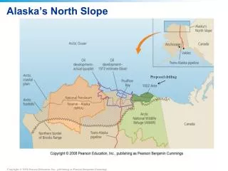
North Slope Science Initiative. Composite Planning GIS Vehicle Routing Tool. Vehicle Routing Decision Process. Input points for departure and destination. Identify Routing Requirement. Basic. Air. Calculate Optimal Path. Choose Method of Conveyance. Choose Interface Level.

E N D
North Slope Science Initiative Composite Planning GIS Vehicle Routing Tool
Vehicle Routing Decision Process Input points for departure and destination Identify Routing Requirement Basic Air Calculate Optimal Path Choose Method of Conveyance Choose Interface Level Generate Cost Surface Land Visualize Path Advanced Return Waypoints Export to GPS Choose buffer size for areas to avoid Choose max slope and suitable land types Prioritize road use Print
Define scale of suitability for land cover 1 is ideal, 10 is impassable Process for Creating a Cost Surface • Add scale of suitability for slope to the land cover to determine ideal surfaces to travel over • Example: Barren ground with a 33% slope becomes a 6 on the final cost surface (2+4) • Note: All land within the buffer of areas to avoid defaults to 10
Vehicle Routing Process (1) • Zoom to area of interest • Start with an initial land cover surface
Vehicle Routing Process (2) • New cost surface is generated • Select criteria to be used in creating new surface
Vehicle Routing Process (3) • Place the start and end locations either interactively by pointing and clicking or by typing in coordinates • Return to Routing Options
Vehicle Routing Process (4) • The route is displayed on the map • Calculate the ideal route
1. -157.77124 69.12976 2. -157.97821 69.16854 3. -158.17854 69.17583 4. -158.37921 69.19987 5. -158.69688 69.25136 Vehicle Routing Process (5) • Waypoint coordinates are displayed in a printable list which may also be exported to a GPS unit • Create waypoints