Download

1 / 11
110 likes | 197 Views
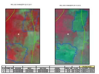
Dive into the world of LISS-III Imagery with this comprehensive guide. Learn how to leverage this advanced imaging technology for geospatial analysis, land cover mapping, and environmental monitoring. Discover key techniques and best practices for maximizing the value of LISS-III data in your projects. Whether you are a GIS professional, researcher, or student, this guide will equip you with the knowledge and skills needed to harness the power of LISS-III Imagery effectively. Stay ahead in the field of geospatial analysis with this essential resource.

E N D
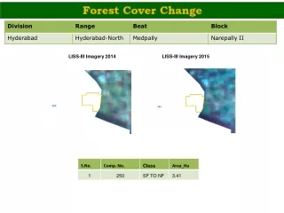
LISS-III Imagery 2012 LISS-III Imagery 2013
LISS-III Imagery 2012 LISS-III Imagery 2013
LISS-III Imagery 2012 LISS-III Imagery 2013
LISS-III Imagery 2012 LISS-III Imagery 2013
LISS-III Imagery 2012 LISS-III Imagery 2013
LISS-III Imagery 2012 LISS-III Imagery 2013
LISS-III Imagery 2012 LISS-III Imagery 2013
LISS-III Imagery 2012 LISS-III Imagery 2013
LISS-III Imagery 2012 LISS-III Imagery 2013
LISS-III Imagery 2012 LISS-III Imagery 2013
LISS-III Imagery 2012 LISS-III Imagery 2013