
Earthquakes
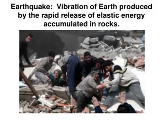
Earthquake: Vibration of Earth produced by the rapid release of elastic energy accumulated in rocks. Earthquakes. Tectonic forces that move crustal blocks cause fractures in the lithosphere called faults .

Earthquakes
E N D
Presentation Transcript
Earthquake:Vibration of Earth produced by the rapid release of elastic energy accumulated in rocks.
Earthquakes • Tectonic forces that move crustal blocks cause fractures in the lithosphere called faults. • Crustal blocks on either side of fault continue to move, resulting friction causes fault to “seize up”. • Elastic energy is stored in rocks adjacent to the jammed up fault, causing them to buckle and deform. • Finally, elastic energy accumulated in the rock exceeds the friction that holds rock along an existing fault line.
Earthquakes and Faults • The earthquake begins at the focus, which is the initial point of rupture along the fault, at depth. • The epicenter is the location on the earth’s surface directly above the focus. • Vibrational energy radiates from the focus in all directions, in the form of waves. Scarp: vertical offset caused by faulting ( in this diagram it’s actually the mountain range).
Earthquake energy • Interior forces (convective flow) push tectonic plates. • at plate boundaries, frictional forces hold plates stationary. While rocks along plate boundary are “stuck”, elastic energy is stored and causes elastic deformation.
Energy release – Elastic rebound • Frictional resistance holding the rocks together is overcome. • Resulting movement releases stored energy as rocks return to original shape.
Energy Storage and Release Released energy is in the form of waves, which cause movement on the earth’s surface and interior
Energy storage and release • Energy release may also result in open fissures (not the same as faults, but dangerous!
Seismology: Study of Wave Energy in the Earth Seismic – relating to earthquakes or earth vibrations
Types of Seismic waves • Body waves travel entirely through earth’s interior • Primary (P) waves • Push-pull (compress and expand) • Travel through solids, liquids, and gases • Secondary (S) waves • Slower velocity than P waves • Slightly greater amplitude than P waves • Travel though solids only Primary wave Secondary Wave
Seismograph • Instrument used to record surface and body waves passing through the earth • More than one type of seismograph is needed to record both vertical and horizontal ground motion • Records obtained are called seismograms
How Big • Modern measurement scales (Richter, moment magnitude) measure the amount of energy released by a quake. • This value is the same no matter how far away from the epicenter the measurement is taken
How Big An earthquake occurs in Pakistan. Pakistanis report a magnitude of 6.2. Scientists in California would probably measure a magnitude of: • Greater than 6.2 • 6.2 • Less than 6.2
How Big An earthquake occurs in Pakistan. Pakistanis report a magnitude of 6.2. Scientists in California would probably measure a magnitude of: • Greater than 6.2 • 6.2 – correct! • Less than 6.2
Magnitude Scales • measure energy released (objective, rather than intensity (subjective) • Logarithmic – each number on the scale increases by a factor of 10, allows wider range
Richter Magnitude (ML) • introduced by Richter and Gutenberg in 1935 for comparison of California earthquakes. • Based on the amplitude (height) of the largest seismic wave recorded during earthquake. • Accounts for the decrease in wave amplitude with increased distance from epicenter • Each unit corresponds to a tenfold increase in wave amplitude and a 32-fold energy increase • Originally for use in California only with a Wood-Anderson torsion seismograph only up to 6.5 • Modern Richter Scales (Ms , Mb ) have been modified and work on all seismographs, measuring up to 8.
The table at the right is my original slide for the amount of energy released (in terms of TNT needed) for Richter Scale measurements. A metric ton = 1000 kg This is before our text included fig. 14.15 (p. 345). There is considerable disagreement!
Here is the source of the information in our text, look at the difference! http://www.iris.edu/hq/files/publications/brochures_onepagers/doc/EN_OnePager3.pdf
Other sources http://www.themeter.net/sism_e.htm http://en.wikipedia.org/wiki/Richter_magnitude_scale http://hvo.wr.usgs.gov/volcanowatch/archive/2008/08_02_21.html
Moment Magnitude (Mw) • developed because none of the “Richter-like” magnitude scales adequately estimates the size of very large earthquakes. Wave amplitude is limited on seismograph. • Derived from the amount of displacement that occurs along a fault • Gained wide acceptance • Measures very large earthquakes more accurately • Can be derived mathematically • Can be verified by field studies and seismographic methods
Map showing major tectonic boundaries and earthquake distribution (in yellow)
Transform boundaries, e.g. San Andreas Fault Zone • Strike-slip fault; movement along fault is mainly horizontal • Fault creep – small, slow movements along fault • Stick-slip movement – fault moves in a series of jolts with no movement in between. Significant energy buildup possible, resulting in is large-magnitude damaging earthquake
Earthquakes and plate boundaries • Convergent boundaries – one plate sliding under another • Benioff zone – upper part of sinking plate, where it scrapes past opposing plate, causing earthquake activity along the down-plunging contact zone.
Earthquakes along divergent boundaries Friction along sliding blocks (transform faults)
Earthquakes in plate interiors • 1811-12, New Madrid, MO, site of aborted divergent boundary • This area is still seeing active movement along the fault.
Tsunami • When an earthquake occurs beneath the sea, the sea floor rises and falls, due to rupture and elastic rebound. • Resulting water displacement forms a fast-moving wave. • In the deep water of the open ocean, tsunami are barely detectable. • In shallow water near shore, the wave speed decreases as it drags against the bottom. • The water “stacks up”, causing a large wall of water to make landfall.
December 2004 Sumatra-Andaman Tsunami • This shows a portion of the convergent boundary between the Eurasian plate and the Indo-Australian plate. The latter is moving northward, pushing against the former • Green star shows epicenter of earthquake that caused tsunami. • Red arrows show plate motion • Red dots show earthquakes > magnitude 5.0, from 1965 to 2004.
Laguna Salada EarthquakeApril 4, 2010 ftp://hazards.cr.usgs.gov/maps/sigeqs/20100404/20100404.jpg This site has some good information about the recent “Easter Quake” near Mexicali. Click on any part of the site to enlarge it
Magnitude 7.0 Energy released is equal to approximately 32 Megatons TNT Why do earthquakes happen in Haiti? The answer is Plate Tectonics!
A close up showing the Caribbean Plate; it’s northern boundary runs through Haiti
the Caribbean Plate moves eastward while the North American Plate moves westward. The yellow lines are faults which define a small microplate:
The red dots show historic earthquake activity. The plates try to move past each other and get stuck, building up a lot of energy in the process
The energy release when the plate gets “unstuck” causes the earthquake and resultant damage


