Download
1 / 4
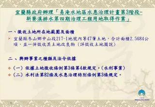
一 、 徵收土地所在地範圍及面積 宜蘭縣冬山鄉中山段 217-1 地號內等 47 筆土地,合計面積 2.5684 公頃,並一併徵收其土地改良物 ( 詳徵收土地圖說 )
40 likes | 143 Views
宜蘭縣政府辦理「易淹水地區水患治理計畫第 3 階段 - 新寮溪排水第四期治理工程用地取得作業」. 一 、 徵收土地所在地範圍及面積 宜蘭縣冬山鄉中山段 217-1 地號內等 47 筆土地,合計面積 2.5684 公頃,並一併徵收其土地改良物 ( 詳徵收土地圖說 ) 二 、 興辦事業之種類及法令依據 ( 一 ) 依據土地徵收條例第 3 條第 4 款規定。 ( 水利事業 ) ( 二 ) 水利法第 82 條及水患治理特別條例第 3 條規定。. 徵收土地圖說 P1. 現況位置及照片 p.1. 舊寮溪向分洪道入口處下游看. 分洪道位置新寮路左側 ( 往上游看 ).
Download Presentation 
一 、 徵收土地所在地範圍及面積 宜蘭縣冬山鄉中山段 217-1 地號內等 47 筆土地,合計面積 2.5684 公頃,並一併徵收其土地改良物 ( 詳徵收土地圖說 )
An Image/Link below is provided (as is) to download presentation
Download Policy: Content on the Website is provided to you AS IS for your information and personal use and may not be sold / licensed / shared on other websites without getting consent from its author.
Content is provided to you AS IS for your information and personal use only.
Download presentation by click this link.
While downloading, if for some reason you are not able to download a presentation, the publisher may have deleted the file from their server.
During download, if you can't get a presentation, the file might be deleted by the publisher.
E N D
Presentation Transcript
宜蘭縣政府辦理「易淹水地區水患治理計畫第3階段-新寮溪排水第四期治理工程用地取得作業」宜蘭縣政府辦理「易淹水地區水患治理計畫第3階段-新寮溪排水第四期治理工程用地取得作業」 一、徵收土地所在地範圍及面積 • 宜蘭縣冬山鄉中山段217-1地號內等47筆土地,合計面積2.5684公頃,並一併徵收其土地改良物 (詳徵收土地圖說) 二、興辦事業之種類及法令依據 • (一) 依據土地徵收條例第3條第4款規定。(水利事業) • (二) 水利法第82條及水患治理特別條例第3條規定。
現況位置及照片 p.1 舊寮溪向分洪道入口處下游看 分洪道位置新寮路左側(往上游看) 分洪道舊寮溪入口往舊寮溪上游看 舊寮溪堤內往下游看 新寮路左側分洪道 (往上游看) 舊寮溪堤防及河道往上游看
現況位置及照片 p.2 分洪道位置新寮路左側(往下游看) 分洪道位置新寮路右側(往下游看) 分洪道出口(往上游看) 分洪道(往上游看) 新寮路右側分洪道(往下游看)


More Related