Download
1 / 15
150 likes | 169 Views
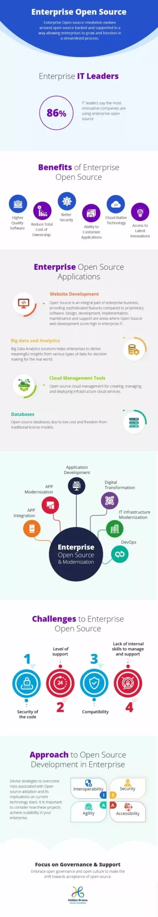
This paper explores the development of an Open Source WebGIS application for the Indian Institute of Remote Sensing campus. It discusses the benefits of open source software and the features of WebGIS. The methodology includes the use of Hugin for creating panoramic images and PTViewer as a viewer for panoramic images.

E N D
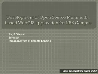
Development of Open Source Multimedia based WebGIS application for IIRS Campus Kapil Oberai Scientist Indian Institute of Remote Sensing India Geospatial Forum 2012
What is Open Source • Open source is a development method for software that harnesses the power of distributed peer review and transparency of process. The promise of open source is better quality, higher reliability, more flexibility, lower cost, and an end to predatory vendor lock-in. (From opensource.org)
So What About Open Source? • Four basic freedoms : • The freedom to run the program, for any purpose. • The freedom to study how the program works, and adapt it to your needs. • The freedom to redistribute copies so you can help your neighbour. • The freedom to improve the program, and release your improvements to the public, so that the whole community benefits. • Why are they using it? • Often free with no up front and recurring fees • Anyone that can’t afford proprietary software • Ability to improve/contribute • Collaborative, community-based software development process
GRASS GIS Open Source GIS – Desktop/Server Tools (The Players) mapserver.gis.umn.edu postgis.refractions.net/ PostGIS / PostgreSQL Spatial Database www.geotools.org grass.itc.it
Features of WebGIS • Wide accessibility, users from the world can access GIS data and analysis tools over the Internet. • No GIS software is required to install locally. • Users can directly manipulate maps and GIS data over the Web. • WebGIS can easily incorporate up-to-date, real-time information • There are many Open Source software available for WebGIS purpose such as MapServer, GeoServer, Degree etc.
Satellite Data QGIS- Generation of GIS Layers (Shapefiles) Web Browser (Visualization through Internet/ Intranet) QGIS SPIT Tool(Loading Shapefile to PostGIS Database) USER INTERFACE Spatial DB APPLICATION SERVER UMN Mapserver & KML MapserverQGIS Plugin- Generation of .map file Apache with UMN Mapserver & KML MapserverWeb Enabled IIRS campus ApplicationMapserver configuration (.map) file Web Enabled IIRS Campus Application (Apache- PHP/Mapscript) DATABASE Spatial database server PostgreSQL/ PostGIS GIS Data WEB BROWSER System Architecture Methodology
Hugin an Open Source panoramastitcher tool was used for creating panoramic images of IIRS which can be visualized through the application to provide a realistic view of IIRS facilities to end user sitting on their workstation (http://hugin.sourceforge.net/) PTViewer 2.8: PTViewer is a java applet that can be used as a viewer for panoramic images. (www.fsoft.it/panorama/ptviewer.htm)


![] project-open [ Open Source Enterprise Business Application](https://cdn2.slideserve.com/4617279/project-open-open-source-enterprise-business-application-dt.jpg)


![] project-open [ Open Source Enterprise Business Application](https://cdn5.slideserve.com/9379245/project-open-open-source-enterprise-business-application-dt.jpg)