Download
1 / 1
30 likes | 307 Views
TS3-A020. subaerial volcanoes. 38 °. seamounts Marsili oceanic basin. Plio Pleistocene peri-Tyrrhenian sedimentary basins. Plio Pleistocene terrains. 15°. 17°. Apennine-Maghrebian chain. Hyblean foreland. Normal fault. N. Trust fault. Strike -slip fault. reverse. strike- slip.

E N D
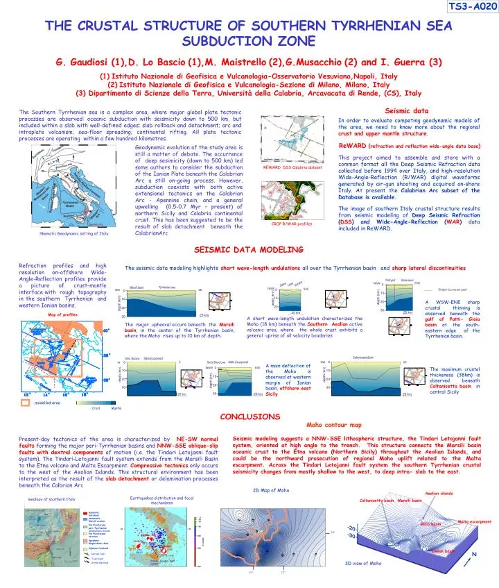
TS3-A020 subaerial volcanoes 38° seamounts Marsili oceanic basin Plio Pleistocene peri-Tyrrheniansedimentary basins Plio Pleistocene terrains 15° 17° Apennine-Maghrebian chain Hyblean foreland Normal fault N Trust fault Strike-slip fault reverse strike- slip normal Ml=5.6 1978 2002 Ml=5.6 Ml=7.1 1908 Tindari-Giardini fault system THE CRUSTAL STRUCTURE OF SOUTHERN TYRRHENIAN SEA SUBDUCTION ZONEG. Gaudiosi (1),D. Lo Bascio(1),M. Maistrello(2),G.Musacchio(2) and I. Guerra (3)(1)Istituto Nazionale di Geofisica e Vulcanologia-Osservatorio Vesuviano,Napoli, Italy (2)Istituto Nazionale di Geofisica e Vulcanologia-Sezione di Milano, Milano, Italy(3) Dipartimento di Scienze della Terra, Università della Calabria,Arcavacata di Rende, (CS), Italy Seismic data The Southern Tyrrhenian sea is a complex area, where major global plate tectonic processes are observed: oceanic subduction with seismicity down to 500 km, but included within a slab with well-defined edges; slab rollback and detachment; arc and intraplate volcanism; sea-floor spreading; continental rifting. All plate tectonic processes are operating within a few hundred kilometres. In order to evaluate competing geodynamic models of the area, we need to know more about the regional crust and upper mantle structure. ReWARD (refraction and reflection wide-angle data base) Geodynamic evolution of the study area is still a matter of debate. The occurrence of deep sesimicity (down to 500 km) led some authors to consider the subduction of the Ionian Plate beneath the Calabrian Arc a still on-going process. However, subduction coexists with both active extensional tectonics on the Calabrian Arc - Apennine chain, and a general upwelling (0.5-0.7 Myr – present) of northern Sicily and Calabria continental crust. This has been suggested to be the result of slab detachment beneath the CalabrianArc This project aimed to assemble and store with a common format all the Deep Seismic Refraction data collected before 1994 over Italy, and high-resolution Wide-Angle-Reflection (R/WAR) digital waveforms generated by air-gun shooting and acquired on-shore Italy. At present the Calabrian Arc subset of the Database is available. by Simone Marzorati REWARD DSS Calabria dataset The image of southern Italy crustal structure results from seismic modeling of Deep Seismic Refraction (DSS) and Wide-Angle-Reflection(WAR) data included in ReWARD. .seismicity CROP R/WAR profiles Skematic Geodynamic setting of Italy SEISMIC DATA MODELING Refraction profiles and high resolution on-offshore Wide-Angle-Reflection profiles provide a picture of crust-mantle interface with rough topography in the southern Tyrrhenian and western Ionian basins. The seismic data modeling highlightsshort wave-length undulations all over the Tyrrhenian basinand sharp lateral discontinuities Tindari-Letoianni fault A WSW-ENE sharp crustal thinning is observed beneath the gulf of Patti- Gioia basin at the south-eastern edge of the Tyrrhenian basin. Map of profiles A short wave-length undulation characterizes the Moho (18 km) beneath theSouthern Aeolianactive volcanic area, where the whole crust exhibits a general uprise of all velocity boudaries The major upheaval occurs beneath theMarsili basin, in the center of the Tyrrhenian basin, where the Moho rises up to 10 km of depth. A main deflection of the Moho is observed at western margin of Ionian basin, offshore east Sicily The maximum crustal thickeness (38km) is observed beneath Caltanisetta basin in central Sicily modelled area Crust Mantle CONCLUSIONS Moho contour map Seismic modeling suggests a NNW-SSE lithospheric structure, the Tindari Letojanni fault system, oriented at high angle to the trench. This structure connects the Marsili basin oceanic crust to the Etna volcano (Northern Sicily) throughout the Aeolian Islands, and could be the northward prosecution of regional Moho uplift related to the Malta escarpment. Across the Tindari Letojanni fault system the southern Tyrrhenian crustal seismicity changes from mostly shallow to the west, to deep intra- slab to the east. Present-day tectonics of the area is characterized byNE-SW normal faultsforming the major peri-Tyrrhenian basins andNNW-SSE oblique-slip faults with dextral componentsof motion (i.e. the Tindari Letojanni fault system). The Tindari-Letojanni fault system extends from the Marsili Basin to the Etna volcano and Malta Escarpment.Compressive tectonicsonly occurs to the west of the Aeolian Islands. This structural environment has been interpreted as the result of theslabdetachment or delamination processes beneath the Calbrian Arc 2D Map of Moho Aeolian islands Earthquakes distribution and focal mechanisms Geology of southern Italy Caltanisetta basin Marsili basin Malta escarpment Gioia basin Ionian basin 3D view of Moho