Download
1 / 59
590 likes | 690 Views
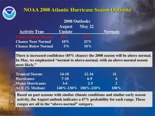
2012 ATLANTIC HURRICANE SEASON. Walter Hays, Global Alliance for Disaster Reduction, University of North Carolina, USA. ACTUAL STORMS EXCEEDED THE FORECAST . FORECAST: 15 NAMED STORMS WITH 4-8 BECOMING HURRICANES. ACTUAL: TWENTY NAMED STORMS; 10 HURRICANES. NAMED STORMS IN 2012.

E N D
2012 ATLANTIC HURRICANE SEASON Walter Hays, Global Alliance for Disaster Reduction, University of North Carolina, USA
ACTUAL STORMS EXCEEDED THE FORECAST FORECAST: 15 NAMED STORMS WITH 4-8 BECOMING HURRICANES
NAMED STORMS IN 2012 • ALBERTO - Tropical storm; May 19 • BERYL - Tropical storm; May 27 • CHRIS – Hurricane; June 21 • DEBBY – Tropical storm; June 23 • ERNESTO –Hurricane; Aug 3 • FLORENCE –Tropical storm: Aug 5 • GORDON –Hurricane, August 16
NAMED STORMS FOR 2012 • HELENE –Tropical Storm, Aug. 19 • ISAAC – Hurricane, August 21 • JOYCE –Tropical Storm, Aug. 25 • KIRK –Tropical Storm. Aug. 27 • LESLIE –Hurricane, Sept. 5 • MICHAEL –Hurricane, Sept. 5 • NADINE – Hurricane, Sept. 12
NAMED STORMS IN 2012 • OSCAR – Tropical Storm; Oct. 4 • PATTY – Tropical Storm; Oct. 11 • RAFAEL – Hurricane; October 12 • SANDY– Hurricane; October 22 • TONY – Tropical Storm; Oct. 24 • VALERIE– Did not happen • WILLIAM – Did not happen
TROPICAL STORM ALBERTO ---FIRST STORM OF 2012 SEASONFORMS OFF SOUTH CAROLINA COASTMay 19-21, 2012
ALBERTO ARRIVED 2 WEEKS BEFORE THE 2012 SEASON BEGAN • Located about 140 miles east-southeast of Charleston, SC, Alberto had sustained winds of 100 kph (60 mph) • As expected, Alberto turned northward and brought rain to the east coast for several days.
ALBERTO’S POSITION: MAY 20-21 • On Sunday, Alberto was 120 miles south of Cape Fear, NC with sustained winds of 83 kph (50 mph) • On Monday, Alberto began to turn eastward, indicating that it will likely stay in the Atlantic Ocean and die there.
TROPICAL STORM BERYL ---SECOND STORM OF 2012 SEASONFORMED OFF NORTH FLORIDA COASTMay 27-28, 2012
BERYL’S POSITION: MAY 28 • Early on Monday morning (12:10 AM), Tropical Storm Beryl made landfall near Jacksonville Beach, FL with near-hurricane winds of 115 kph (70 mph). • A rain-maker, Beryl, dumped 10-20 cm (4-8 inches) of rain; a welcome relief for the drought-stricken region. • Beryl weakened quickly
BERYL: A RAINMAKER • Beryl became a rainmaker as it weakened and moved northward along the USA’s east coast, complicating the Memorial Day holiday traffic.
TROPICAL STORM CHRIS ---BECAME FIRST HURRICANE OF 2012 SEASONNO THREAT TO LAND DURING SHORT LIFEJune 21, 2012
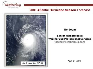
HURRICANE CHRIS • Chris had 120 kph (75 mph) winds and was located about 625 miles (1005 km) southeast of Cape Race, Newfound-land, Canada. • It was moving to the northeast at 32 kph (20 mph) with a minimum central pressure of 987 millibars.
TROPICAL STORM DEBBY ---FOURTH STORM OF 2012 SEASONFORMED IN GULF SOUTHWEST OF FLORIDAFIRST TIME IN HISTORY FOR FOUR NAMED STORMS BEFORE JULY 1ST June 23, 2012
DEBBY: ANTICIPATORY ACTIONS; JUNE 24 • Debby expected to become a CAT I hurricane • Storm warnings issued from Texas to Florida • Oil rigs in gulf of Mexico begin to shut down production and plan evacuations • Coastal States begin to implement emergency response plans
On June 24th, Debby dumped up to 60 cm (24 inches) of rain on parts of Florida and spawned some isolated tornadoes The center of the storm continued to be essentially stationary, increasing the likelihood of being a big rainmaker
FLORIDA’S GOVERNOR, RICK SCOTT, DECLARES STATE OF EMERGENCY MONDAY, JUNE 25
Tuesday, June 26Debby, barely a tropical storm, finally made landfall Tuesday afternoon near Steinhatchee in the Big Bend area, with a 60 cm (2 foot) storm surge and sustained winds near 66 kph (40 mph).
INITIAL IMPACTS IN FLORIDA • Four straight days of rain • The storm left 29,000 people without power across the central and northern parts of the state. • Mandatory evacuation ordered for 14,000 to 20,000 people living between the Anclote and Pithlachascotee Rivers.
INITIAL IMPACTS IN FLORIDA • The capital, Tallahassee, was cutoff from Jacksonville due to flooding of the Interstate Highway • Debby was expected to bring another 10-20 cm (4 to 8 inches) of rain as it moved across Florida, possibly strengthening again after reaching the Atlantic Ocean
Wednesday, June 27Debby is expected to cross the state and head into the Atlantic on Wednesday afternoon.
JULY 14 NOTE:: Experts are now saying that2012 is turning out to be an EL NINO YEAR (i.e., a warmer Pacific and a cooler Atlantic than was the case in 2011)
TROPICAL STORM ERNESTO ---FIFTH STORM OF 2012 SEASONSPEEDING TOWARDS THE CARIBBEANThe storm is centered about 90 miles (145 kilometers) west of St. Lucia. And moving west near 21 mph (34 kph). August 3, 2012
TROPICAL STORM FLORENCE ---SIXTH STORM OF 2012 SEASONFORMED IN EASTERN ATLANTICThe storm, which was moving westward and 515 miles (830 km) west of the southernmost Cape Verde Islands, died quicklyAugust 5, 2012.
Ernesto was a weak hurricane when it made its first landfall late Tuesday (Aug. 7) near the cruise ship port of Mahahual in Yucatan,
Ernesto’s second landfall on Thursday (Aug 9) was as a “Rainmaker” near the Mexican oil port city of Coatzacoalcos Three people killed
WHAT HAPPENED AFTER LANDFALL? • Heavy rains continued into Friday night as Ernesto’s winds declined quickly to 40 mph (65 kph). .
TROPICAL STORM GORDON ---SEVENTH STORM OF 2012 SEASONFORMED IN EASTERN ATLANTICThe storm is moving westward at present.August 16, 2012.