Download
1 / 38
380 likes | 398 Views
Understand the difference between accuracy and precision in measurement, types of errors, and methods to minimize random and systematic errors. Learn about expressing errors, temperature measurements, atmosphere and wind measurement techniques, and precipitation monitoring. Explore instruments like barometers, anemometers, and wind profilers.

E N D
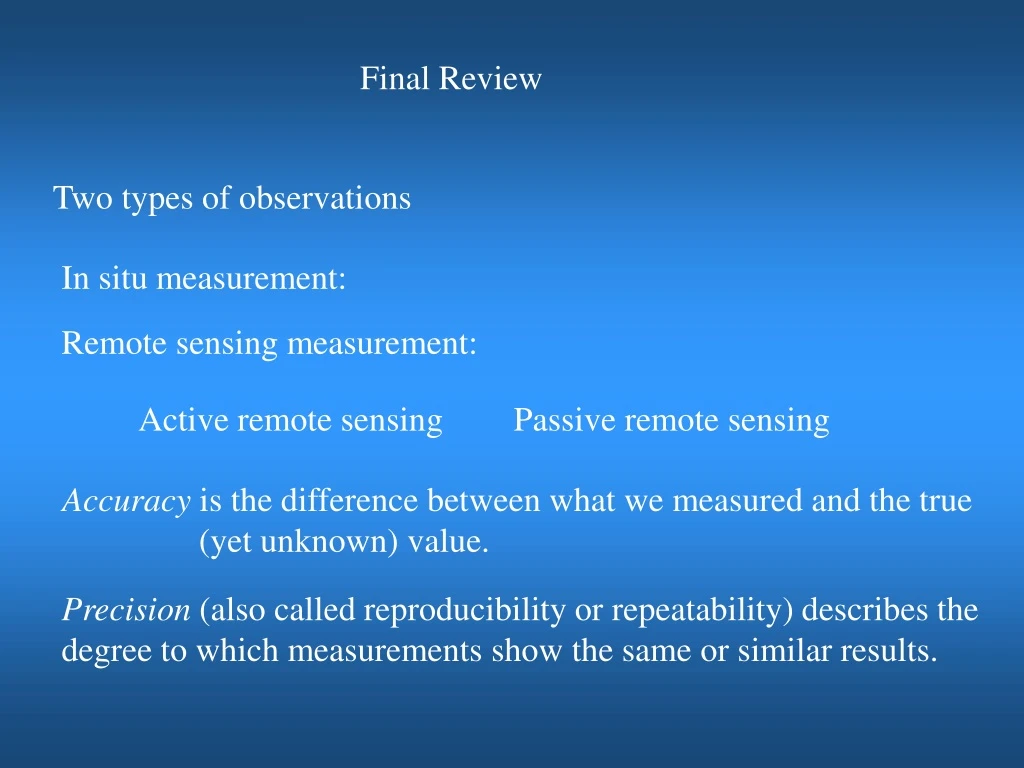
Final Review Two types of observations In situ measurement: Remote sensing measurement: Active remote sensing Passive remote sensing Accuracy is the difference between what we measured and the true (yet unknown) value. Precision (also called reproducibility or repeatability) describes the degree to which measurements show the same or similar results.
Random error is the variation between measurements, also known as noise. Unpredictable Zero arithmetic mean Random error is caused by • unpredictable fluctuations of a measurement apparatus, • the experimenter's interpretation of the instrumental reading; A common method to minimize random error is to make multiple observations. Systematic errors are biases in measurement which lead to the situation where the mean of many separate measurements differs from the actual value of the measured attribute. A common method to remove systematic error is through Calibration of the measurement instrument.
How to express errors e (unit) ± Δe, e.g., Unit Error: Percent Error: Averaging Variance Standard deviation Covariance Correlation coefficient
Estimating Errors of derived variables/Propagation of Errors Max error: Significant figures 1. 37.76 + 3.907 + 226.4 = 2. 319.15 - 32.614 = 3. 104.630 + 27.08362 + 0.61 = 4. 125. - 0.23 + 4.109 = 5. 2.02 x 2.5 = 6. 600.0 / 5.2302 = 7. 0.0032 x 273 = 8. (5.5)3 = 9. 0.556 x (4x101 - 32.5) = 10. 45. x 3.00 = 11. 3.00 x 10⁵ - 1.5 x 102 = 12. What is the average of 0.1707, 0.1713, 0.1720, 0.1704, and 0.1715?
Temperature measurements Absolute temperature (Kelvin) Thermometer Calibrations Three reference points 1. Liquid in glass thermometer Volume expansion of glass:1.2-2.7x10⁻⁵ per 1.00oC, Volume expansion ofHg:18x10-5 per 1.00oC 2. Maximum thermometer 3. Minimum thermometer
Making temperature measurements in the atmosphere 1. Air is a poor conductor, thus, a good flow over the sensor should be maintained. 2. Sensor to be thermally insulated from the mounting. 3. To prevent radiation, sensors can be polished or coated to reflect solar radiation and to reduce the absorption of infrared radiation. A shield can also be used to shelter the sensor, but it needs to be aspirated to ensure proper ventilation. 4. Heating by adiabatic compression may occur when a sensor is exposed to air moving at very high rates, e.g., aircraft measurements. Adiabatic heating needs to be corrected. 5. Wetting of a temperature sensor will lower the measured temperature due to evaporative cooling. Upper air measurements can be affected as a sensor goes though a cloud. A special device is needed to prevent sensor wetting. For surface measurements, the radiation shield should keep the sensor dry.
Moisture Measurement Mixing ratio, r Relative humidity, h Dew-point, TD Wet bulb temperature, TW How to use sling psychrometer
Atmospheric pressure measurement Absolute pressure, Gage pressure, Differential pressure Two types of fluid systems: static and dynamic Static pressure Dynamic pressure Total (or Stagnation) pressure Barometers Mercury barometer Temperature correction Gravity correction How to use: Fortin Barometer Eco-Celli Barometer Aneroid Barometer Barographs
Precipitation Precipitation rate (R): rain water falling on ground per unit area per unit time Ordinary rain gauge Tipping bucket rain gauge Advantage and disadvantage for ordinary and tipping bucket rain gauge
Optical rain gauge (ORG) A ORG measures the scintillation in an optical beam produced by raindrops falling between a light source and an optical receiver. Disdrometer • Measuring the speed of falling droplets. 2. Droplet size distribution
Wind Measurements Local right-hand Cartesian coordinate W Up North y V x U East O O Polar coordinate
Dynamic force anemometers cup anemometers, vane windmill, and gill-type anemometers Pressure pulse frequency anemometers (sonic anemometer ) It measures the variation of speed of sound with wind
2-D sonic anemometer 3-D sonic anemometer The spatial resolution is given by the path length between transducers, which is typically 10 to 20 cm Sonic anemometers can take measurements with very fine temporal resolution, 20 Hz or better, which make them well suited for turbulence measurements. Their main disadvantage is the distortion of the flow itself by the structure supporting the transducers, which requires a correction based upon wind tunnel measurements to minimize the effect.
Wind profilers • A wind profiler is a type of sensitive Doppler radar that uses electromagnetic waves or sound waves to detect the wind speed and direction at various elevations above the ground, up to the troposphere (i.e., between 8 and 17 km above mean sea level) • Detection of the signal backscattered from refractive index in-homogeneities in the atmosphere • In clear air, the scattering targets are the temperature and humidity fluctuations produced by turbulent eddies
Measuring horizontal winds using three beams Doppler Shift where Vris the radial velocity of the scatterers. is wave length
The 915 MHz (33 cm, UHF) profiler measures the wind at low levels, typically up to 1-3 km above ground level, depending on atmospheric conditions, especially humidity. The 915 MHz profiler has fairly small antennas (at most 2x2 or 3x3 m), making it transportable and less expensive. A VHF wind profiler (50 MHz or 6 m) measures wind profiles between 2 and 16, occasionally 20 km above the ground level (AGL), but the antenna occupies 2 soccer fields (100x100m). The US NOAA operates a network of 400 MHz wind profilers. These are smaller (antenna size about 10 x10 m). The higher the frequency, the smaller the antenna, the smaller the turbulent flow scale that is resolved. Frequency 50 MHz 405 MHz 915 MHz Wavelength 600 cm 74 cm 33 cm Antenna 100 m 13 m 2 m
Radiosonde Radiosonde is a small, expendable instrument package that is suspended below a large balloon filled with hydrogen or helium. The radiosonde consists of sensors used to measure several meteorological parameters coupled to a radio transmitter and assembled in a lightweight box. The meteorological sensors sample the ambient temperature, relative humidity, and pressure of the air through which it rises. By tracking the position of the radiosonde, wind speed and direction aloft are also obtained.
Transmitter operates on a frequency from 1668.4 to 1700.0 MHz The altitude reached by rawinsonde varies for several reasons: • bursting height of the balloon; • faulty receiving equipment; • atmospheric interference. When the balloon reaches its elastic limit and bursts, the parachute slows the descent of the radiosonde, minimizing the danger to lives and poperties. 600-gram balloon can rise approximately 90,000 feet. The bursting altitude for larger 1,200-gram balloon exceeds 100,000 feet. Launch each day at 00:00 and 12:00 UTC (Greenwich Mean Time),
GPS Dropsondes Dropsonde is a weather reconnaissance device created by the National Center for Atmospheric Research (NCAR), designed to be dropped from an aircraft at altitude to accurately measure tropical storm conditions as the device falls to the ground. The dropsonde contains a GPS receiver, along with pressure, temperature, and humidity sensors to capture atmospheric profiles and thermodynamic data and winds.
Driftsondes It is a new type of observing system to track weather above hard-to-reach parts of the globe, as well as make soundings that will fill critical gaps in data coverage over oceanic and remote arctic and continental regions. These areas include (1) relatively void of in-situ measurements from radiosondes and commercial aircraft, such as the remote Pacific and Atlantic oceans, (2) covered with extensive cloud shields so that satellite measurements are limited.
Radiation Energy flux- Laws of blackbody radiation 1. Plank’s law 2. Wien’s displacement law Gray body:
Making Radiation Measurements There are three ways to make radiation measurements. • Thermal sensitive devise • Photoelectric cell (photodiode) • Photochemical sensor Factors affecting measurement of radiative fluxes using thermal sensitive devise. Purpose of glass dome What is the basic operating principle for the photoelectric cell? A device that converts light into electricity. What is the basic operating principle for the photochemical sensor? It utilizes materials that tend to have chemical reaction due to the absorption of light (including visible, ultraviolet, and infrared).
Broadband Radiation Instruments: Shortwave K Longwave L Total Q = K + L Spectral Radiation Instruments: Pyranometer measures global-solar shortwave radiation Shaded Pyranometer measures diffuse solar radiation Pyrheliometer measures direct beam Pyrradiometer measures net radiation
Weather radar Radar: RAdio Detection And Ranging 1. EM waves that fall into the microwave (1 mm < λ < 75 cm) 2. Active remote sensing technique Fundamental properties of the emitted beam: Pulse repetition frequency (PRF): how many pulses of radiation are transmitted per second; for typical weather radars, typically 325. Transmission time: the duration of each pulse Pulse length: the spacing between “range gates” and is 1 km on average. It determines radial resolution. Beam width: the angular width of the emitted beam, and is typically about 1°. It determines angular resolution Pulse volume: volume determined by pulse length and beam width
Attenuation Particles will attenuate the energy in two ways: scattering and absorption, collectively known as attenuation Particles: raindrop, hail, snow, graupel, insects,….. Rayleigh Scattering Scattering from molecules and tiny particles (< 1 /10 wavelength) It has a strong dependence on wavelength. Mie Scattering Scattering from relatively large particles (~ or > 1 wavelength). Large particles are able to scatter all wavelengths of light roughly equally, i.e., scattering is not strongly wavelength dependent and produces a sharper and more intense forward lobe
Scan Angle To keep the beam from hitting objects on the ground, the lowest scan angle used is 0.5° above horizontal. Moments The 0th moment: reflectivity The 1st moment: radial velocity The 2nd moment: spectrum width Distribution of velocities within a pulse volume. Reflectivity dBZ Z-R Relationship R is the rainfall rate (mmh-1)
Frequencies WEATHER RADAR BANDS High frequency, short-wavelength bands are readily attenuated by small droplet, making them most useful for detecting clouds and aerosols. The longer the wavelength, the less attenuation. Long wavelength radar cannot “see” small cloud droplets but can detect large condensate droplets and hails. S-band radars are widely used by the NWS.
Radar scanning PPI (Plan Position Indicator) RHI (Range Height Indicator) Vertically Pointing PRODUCT INTERPRETATION Light snow and rain: 5-20 dBZ, moderate rain: 30-45 dBZ, Heavy rain, hail: 60-75 dBZ a) Reflectivity b) Radial Velocity Deduce the lower-tropospheric vertical wind profile Dual Doppler Can be used to determine the 3-dimensional wind field (U,V,W) from the radial velocities obtained from a Doppler radar
Weather radars NEXRAD: WSR-88D Clear Air Mode The radar rotates slower and performs fewer scan angles. This allows for higher resolution of fine targets such as aerosol particles (smoke plumes for example), insects, and snow. It completes 5 elevation scans in five minutes. Precipitation Mode The radar rotates faster and performs more scan angles, sacrificing resolution for more rapid updates. The radar completes 9 different elevation scans in five minutes. Severe Mode The rotation rate is increased even further and more scans are made at higher angles to capture the full structure of the towering thunderstorms. It completes 14 elevation scans in five minutes.
Clouds Liquid water mixing ratio Liquid water density of clouds Cloud droplet distribution Number density N (D): the number of droplets per unit volume (concentration) in an interval D + ΔD
Instruments that can determine hydrometeor mixing ratio and particle size distribution FSSP (forward scattering spectrometer probe) The FSSP is of the general class of instruments called optical particle counters (OPCs) that detect single particles and size them by measuring the intensity of light that the particle scatters when passing through a light beam. Optical Array probe It uses an array of photodiodes to measure the size of hydrometeors from the maximum width of their shadow as they pass through a focused He-Ne laser beam.
Ceilometer Ceilometer is an instrument for the measurement of cloud base. The device works day or night by shining an intense beam of light (often ultraviolet) at overhead clouds. Reflections of this light from the base of the clouds are detected by a photocell in the receiver of the ceilometer. The height can be determined using the emitted and received light. Cloud Radar (w band) Cloud reflectivity and vertical velocity
Polar orbit satellite Altitudes are typically at 850 km. Orbital periods are about 98-102 minutes. Hence, each satellite will complete about 14 orbits in one day. The scan swath is about 3000 km wide. Note that the orbit is directed to the northwest. The satellites do not pass directly over the North pole or South Pole creating a precession in the orbit so that is passes over locations further west on subsequent orbits.
Factors affecting data resolution • Subpoint: the location on the earth that is directly below the satellite. • Satellite footprint: the area being scanned by the satellite, similar to the area being photographed with a camera. • Nadir angle: the angle between the footprint and the subpoint. Accordingly, the resolution gets worse with increasing nadir angle. • Resolution is a function of: (a) Curvature of the earth. (b) to a lesser extent, the increasing distance of the footprint from the satellite. • Data at angles greater than 60° are not very useful Parallax refers to the displacement of cloud locations due to increasing viewing angle.
Geostationary Satellites • Geostationary satellites orbit in the earth's equatorial plane at a height of 35,800 km. Note that the typical space shuttle orbit is only 225-250 km. • At this height, the satellite's orbital period matches the rotation of the Earth, so the satellite seems to stay stationary over the same point on the equator. It always view the same geographical area, day or night. • This is ideal for making regular sequential observations of cloud patterns over a region with visible and infrared radiometers • High temporal resolution and constant viewing angles. Gravitational force = Centrifugal force