Maps and Navigation
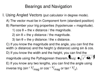
Maps and Navigation. Dividing up the Globe. 1 degree (1°) = 60 minutes (60’) 1 minute (1’) = 60 seconds (60”). For Example. Boerne, TX Latitude: 29° 48’N Longitude: 98 ° 43’W . Navigation Terms. Distance Nautical mile 1 minute 1.85 km 1.15 miles Speed

Maps and Navigation
E N D
Presentation Transcript
Dividing up the Globe • 1 degree (1°) = 60 minutes (60’) • 1 minute (1’) = 60 seconds (60”)
For Example... • Boerne, TX • Latitude: 29° 48’N • Longitude: 98 ° 43’W
Navigation Terms • Distance • Nautical mile • 1 minute • 1.85 km • 1.15 miles • Speed • Knots (nautical miles per hour)
If you want to travel from Austin (Latitude 30° 17' N) to Oklahoma City (35° 24‘ N) how many nautical miles would you drive? How many miles?
Topographic Map • Physical features and contours • Contour line – connects elevations of equal height • Contour interval – vertical distance between contour lines • Example
Bathymetric Map • “Depth-measuring” map
Measuring Depths • Soundings – earliest with rope, now with SONAR • (Sound navigation ranging) • Multibeam sonar
Captain Jim is running the sonar aboard the “SS Champion”. In a certain location the sound pulses return to the ship in 5.2 seconds. How deep is the ocean at his location?