
Introduction
6.30 10.30 11.30 12 12.30 13.30 17.30. Local Time, hr. Enhanced Observation Capability of the New Generation Geostationary Satellites for Better Vegetation Monitoring Peter Romanov 1 , Hui Xu 2 and Dan Tarpley 3

Introduction
E N D
Presentation Transcript
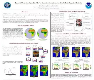
6.30 10.30 11.30 12 12.30 13.30 17.30 Local Time, hr Enhanced Observation Capability of the New Generation Geostationary Satellites for Better Vegetation Monitoring Peter Romanov1, Hui Xu2 and Dan Tarpley3 1 CICS, University of Maryland, College Park, MD, USA ; Email: Peter.Romanov@noaa.gov 2 IMSG Inc., Kensington, MD, USA ; Email: Hui.Xu@noaa.gov 3 NOAA/NESDIS/STAR, Camp Springs, MD, USA ; Email: Dan.Tarpley@noaa.gov Seasonal Changes of Daily and Weekly NDVI Products Introduction GOES-R ABI will be the first GOES imaging instrument providing observations in both the visible and the near infrared spectral bands. Therefore it can be used to generate vegetation index for monitoring the state of the vegetation cover as well as identifying vegetation stress and drought. In addition to its improved spectral capability, the advantage of GOES-R ABI consists in its enhanced spatial (c. 2 km) and temporal (every 5 min.) resolution. This presentation presents the results of the work on generating NDVI and evaluating compositing algorithms using Meteosat 8/9 SEVIRI data as a proxy for GOES-R ABI prototype. A set of remapped and reprojected MSG SEVIRI half-hourly images covering Europe and Africa has been analyzed since May 2006. Collection of a set of SEVIRI full-disk 2-byte images started in late February 2007. Both of these datasets are used to test NDVI algorithms and assess their accuracy. The seasonal changes of derived NDVI are examined over selected target areas in different land surface types such as deserts, grasslands, croplands, shrublands and forests. Since vegetation cover properties do not change fast in general, the stability of NDVI during a day and smoothness of the seasonal change of NDVI will be considered as the primary indicator of good quality of the data. As can be seen, the daily composites are subject to cloud contamination, more so for locations in the rainy seasons. But weekly NDVI products have minimal cloud contamination and reveal the seasonal changes more smoothly. Daily and Weekly NDVI Products Daily and weekly NDVI products are generated using the maximum NDVI compositing algorithms. Examples of NDVI products derived from MSG SEVIRI full disk data are presented here for September 9, 2007. The first one is the daily NDVI composite using the maximum NDVI during the day (a). The second one is the weekly NDVI composite (b), using the maximum NDVI values during the past 7 days. Cloud and ocean masks have been applied to the NDVI maps. The frequent data availability increased the chance of eliminating cloud contamination in the composites. Comparison of MSG SEVIRI and NOAA AVHRR NDVI Products The following example shows the comparison of NDVI maps generated from MSG SEVIRI data and NOAA AVHRR data for the weeks of July 16-22, 2006 and August 19-25, 2006 respectively. It is expected that SEVIRI and hence, future GOES-R ABI-based NDVI products, will offer less cloud contaminated NDVI products because of the availability of multiple daily views. However, the satellite viewing zenith angle variations for different locations may cause inconsistency in the spatial distribution of the derived NDVI since NDVI depends on the viewing and illumination geometry. For example, NDVI estimated for two scenes with identical vegetation cover but located right beneath the satellite and at the edge of the disk scan may be different. To evaluate the magnitude of this effect, it requires further comparison of NDVI derived from geostationary satellites with NDVI from polar orbiting satellite data. (a) Daily composite (09/09/2007) (b) Weekly composite (09/09/2007) Diurnal Variations/Bidirectional Effects of NDVI Products July 19, 2006 MSG and AVHRR NDVI Weekly max NDVI composite averaged within 1x1 deg area MSG and AVHRR NDVI Weekly max NDVI composite averaged within 1x1 deg area Diurnal variations of the derived NDVI are evaluated for different land cover types and for different seasons. The following example illustrates the temporal variations on July 19, 2006 for several selected locations in Africa and western Europe. The graphs show that satellite-observed NDVI may experience large changes during the day due to changing viewing-illumination geometry. Overall, NDVI decreases in the early morning and in the evening. MSG SEVIRI Derived from half-hourly images at 4 km resolution NOAA-18 AVHRR (derived from 16 km GVIx) NOAA-18 AVHRR (derived from 16 km GVIx) MSG SEVIRI Derived from half-hourly images at 4 km resolution July 16-22 2006 Aug 19-25 2006 MSG and AVHRR NDVI vs MSG satellite zenith angle MSG and AVHRR NDVI vs MSG satellite zenith angle Most frequently maximum NDVI value is observed from 9 AM to 11 AM local time. (see the graph and maps below). Jul 18-24, 2006 Oct 27 – Nov 2, 2006 Jan 10-16, 2007 Summary and Future Work Experiments with Meteosat 8/9 SEVIRI data have demonstrated a good potential of new generation imaging instruments onboard geostationary satellites to provide routine monitoring of the vegetation state through NDVI. Using MSG SEVIRI as GOES-R ABI prototype, we have developed the first version of NDVI retrieval algorithm for ABI. The major problems that has to be solved in order to achieve consistency in NDVI estimates in time and space are improved cloud masking and proper correction of NDVI for variable viewing and illumination geometry. Presented at the fifthGOES-R Users’ Conference, as part of the 88th AMS Annual Meeting in New Orleans, LA, 20-24 January 2008.


