Download
1 / 2
20 likes | 131 Views
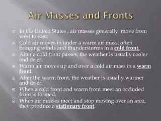
Air Masses and Fronts. In the United States , air masses generally move from west to east. Cold air moves in under a warm air mass, often bringing winds and thunderstorms in a cold front. After a cold front passes, the weather is usually cooler and drier.

E N D
Air Masses and Fronts • In the United States , air masses generally move from west to east. • Cold air moves in under a warm air mass, often bringing winds and thunderstorms in a cold front. • After a cold front passes, the weather is usually cooler and drier. • Warm air moves up and over a cold air mass in a warm front. • After the warm front, the weather is usually warmer and drier. • When a cold front and warm front meet an occluded front is formed. • When air masses meet and stop moving over an area, they produce a stationary front.
Air Masses and Fronts • A front is a boundary between air masses with different temperatures. It marks the leading edge (front) of the air mass. • Fronts often cause rainy, unsettled weather. • An air mass is large region of air that has similar properties (humidity and temperature). Air masses: Continental Polar – dry, cold air Continental Tropical – dry, hot air Maritime Polar – moist, cool air Maritime Tropical – moist, warm air