Download
1 / 53
530 likes | 617 Views
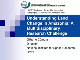
Delve into the multidisciplinary research challenge of Amazonia's land change, conservation, economic development, and population impacts in a series of talks by Gilberto Câmara from INPE. Explore environmental modeling, computational methods, and policy concerns.

E N D
IGERT Colloquim Series, Department of Geography, SUNY Bufallo, February 2007 Understanding Land Change in Amazonia: A Multidisciplinary Research Challenge Gilberto Câmara Director National Institute for Space Research Brazil
INPE - brief description • National Institute for Space Research • main civilian organization for space activities in Brazil • staff of 1,800 ( 800 Ms.C. and Ph.D.) • Areas: • Space Science, Earth Observation, Meteorology and Space Engineering
Environmental activities at INPE • Numerical Weather Prediction Centre • medium-range forecast and climate studies • LANDSAT/SPOT Receiving and Processing Station • in operation since 1974 • China-Brazil Earth Resources Satellite • 5 bands (3 visible, 1 IR) at 20 m resol. • Research Activities in Remote Sensing • 300 MsC and PhD graduates • ONU-funded Center for Africa and S. America
The Future of Brazilian Amazon • Why is this an multidisciplinary research challenge? • Amazonia is a key environmental resource • Many different concerns • Environment and biodiversity conservation • Economic development • Native population
Can we avoid that this…. Source: Carlos Nobre (INPE)
Fire... ….becomes this? Source: Carlos Nobre (INPE)
Amazonia at a glance ... The Natural System • Almost 6 million km2 of contiguous tropical forests • Perhaps 1/3 of the planet's biodiversity • Abundant rainfall (2.2 m annually) • 18% of freshwater input into the global oceans (220,000 m3/s) • Over 100 G ton C stored in vegetation and soil • A multitude of ecosystems, biological and ethnic diversity Source: Carlos Nobre (INPE)
We might know the past…. Estimativa do Desmatamento da Amazônia (INPE)
Source: Carlos Nobre (INPE) Deforestation...
Environmental Modelling in Brasil • GEOMA: “Rede Cooperativa de Modelagem Ambiental” • Cooperative Network for Environmental Modelling • Established by Ministry of Science and Technology • Long-term objectives • Develop models to predict the spatial dynamics of ecological and socio-economic systems at different geographic scales, • Support policy decision making at local, regional and national levels, by providing decision makers with qualified analytical tools.
Application of multidisciplinary knowledge to produce a model. Modelling Complex Problems If (... ? ) then ... Desforestation?
What is Computational Modelling? • Design and implementation of computational enviroments for modelling • Requires a formal and stable description • Implementation allow experimentation • Rôle of computer representation • Bring together expertise in different field • Make the different conceptions explicit • Make sure these conceptions are represented in the information system
Public Policy Issues • What are the acceptable limits to land cover change activities in the tropical regions in the Americas? • What are the future scenarios of land use? • How can food production be made more efficient and productive? • How can our biodiversity be known and the benefits arising from its use be shared fairly? • How can we manage our water resources to sustain our expected growth in urban population?
Modelling Land Change in Amazonia • How much deforestation is caused by: • Soybeans? • Cattle ranching? • Small-scale setllers? • Wood loggers? • Land speculators? • A mixture of the above?
Soybeans Ranchers Small-scale Farming Challenge: How do people use space? Loggers Competition for Space Source: Dan Nepstad (Woods Hole)
What Drives Tropical Deforestation? % of the cases 5% 10% 50% Underlying Factors driving proximate causes Causative interlinkages at proximate/underlying levels Internal drivers *If less than 5%of cases, not depicted here. source:Geist &Lambin
Different agents, different motivations • Intensive agriculture (soybeans) • export-based • responsive to commodity prices, productivity and transportation logistics • Extensive cattle-ranching • local + export • responsive to land prices, sanitary controls and commodity prices
photo source: Edson Sano (EMBRAPA) Large-Scale Agriculture
Different agents, different motivations • Small-scale settlers • Associated to social movements (MST, Church) • Responsive to capital availability, land ownership, and land productivity • Can small-scale economy be sustainable? • Wood loggers • Primarily local market • Responsive to prime wood availability, official permits, transportation logistics • Land speculators • Appropriation of public lands • Responsive to land registry controls, law enforcement
Altamira (Pará) – MODIS Image – 21 May 2004 Imagem Modis de 2004-05-21, com excesso de nuvens
Altamira (Pará) – MODIS Image – 22 June 2004 6.000 hectares deforested in one month!
Modelling Land Change in Amazonia Territory (Geography) Money (Economy) Culture (Antropology) Modelling (GIScience)
“Current and future development axes” Current roads Planned roads BR-174 Transamazônica BR-230 Belém/Brasília BR-319 Cuiabá-Santarém BR-163 Cuiabá-Porto Velho BR-364 Prodes 2003/2004 (INPE, 2005) Estudos Avançados nº 53 (Théry, H.; 2005)
Dynamic areas (current and future) New Frontiers INPE 2003/2004: Intense Pressure Deforestation Forest Future expansion Non-forest Clouds/no data
Amazonian new frontier hypothesis (Becker) • “The actual frontiers are different from the 60’s and the 70’s • In the past it was induced by Brazilian government to expand regional economy and population, aiming to integrate Amazônia with the whole country. • Today, induced mostly by private economic interests and concentrated on focus areas in different regions.
Integrated Land Use and Land Cover Change Modeling in Pará http://www.geoma.lncc.br
Land use and Land Cover Dynamics in São Félix do Xingu-Iriri (PA)
Iriri River S. F Xingu Novo Progresso Xingu River
Transamazônica Rio Iriri Rio Xingu Rio Iriri Reservas Indígenas Accumulated Deforestation Annual rate Escada et al, 2005 – Estudos Avançados , Nº 54
Land Appropriation Model Araújo (2004) Escada et al (2005) Small- medium farms Primary occupation Land permits Violent Expropriation Illegal registration Large farms Illegal money Legal money
Cattle ranching and deforestation Source: DePará, 2005 Amount of cattle head Accumulated Deforestation Museu Paraense Emílio Goeldi e Embrapa Oriental Escada et al, 2005 – Estudos Avançados , Nº 54
Cattle Ranching Model Forest F P Pasture P+R Pasture + Relief Forest + Relief Degraded Pasture Recovered Pasture PD F+R RP
Agents in Terra do Meio P - Small G, M - Large, Medium R - Riverside T Pequenos e Médios Grandes T G Toca do Sapo Ribeirinhos G G L. Jaba Área em disputa (CPT, 2004) G G P Cutia P Estrada Canopus G Branquinho L. Caraíba . F. Cheiro P Primavera 10 km P T G Tibornea G P Estrada dos fazendeiros G P, M T G Source: CPT(2004) , Taravello, R. (2004), Isa (2001) , Geoma(2004), Escada et al (2005)
Population Flux: seasonality Dry season flux Rain season flux
Analysis of public policy: Conservation units in Pará Parque Nacional da Serra do Pardo - 5% df RESEX Riozinho do Anfrísio ESEC Terra do Meio Flona de Altamira Canopus Fazendeiros 0 50 km Prodes 2004(INPE, 2005) Escada et al, 2005
Sample of results • Test 2: Without demand or regression regionalization; • Test 8: With demand and regression regionalization (one model for fine scale partition – Arco, Central and Occidental); • Test 13: With demand and regression regionalization (Arco regression model used at Central partition).
Statistics: Humans as clouds Statistical analysis of deforestation
Land Change Model (1997-2015) Projected hot spots of deforestation 1997- 2015: Federative States Regionalizing the demand improves pressure on Central area, but Central area regressions emphasizes proximity to ports and rivers, due to historical process in the area, and not connectivity to the rest of the country. Roads Percentage of change in forest cover from 1997 to 2015: 0% -> 100%
Impact of the proposed Manaus-Porto Velho road Rede Temática GEOMA Setembro, 2006
Área de estudo – ALAP BR 319 e entorno ALAP BR 319 Estradas pavimentadas em 2010 Estradas não pavimentadas Rios principais Portos new road
BASELINE SCENARIO – Hot spots of change (1997 a 2020) % mudança 1997 a 2020: 0.0 – 0.1 0.1 – 0.2 0.2 – 0.3 0.3 – 0.4 0.4 – 0.5 0.5 – 0.6 0.6 – 0.7 0.7 – 0.8 0.8 – 0.9 0.9 – 1.0 ALAP BR 319 Estradas pavimentadas em 2010 Estradas não pavimentadas Rios principais
GOVERNANCE SCENARIO – Differences from baseline scenario Differences: Protection areas ALAP BR 319 Estradas pavimentadas em 2010 Less: 0.0 -0.50 Sustainable areas Estradas não pavimentadas More: 0.0 0.10 Rios principais