Download
1 / 27
270 likes | 299 Views
Explore the impact of erosion and glaciers on Earth's surface. Learn about mass movement, deposition, glaciers, wind erosion, water erosion, and more. Discover how landscapes are shaped and changed over time.

E N D
Erosion • Wearing away of surface materials by gravity, water, wind, or glaciers. • Deposition- process where sediments are dropped by erosion agents as they lose energy.
Mass movement occurs as gravity moves materials down a slope as one large mass. • Examples: Slumping, Creeping, Rock Falls/Slides, & Mudflows • Steep slopes can be made safer with vegetation, drainage pipes, and walls of concrete or railroad ties.
Glaciers • Large masses of ice and snow that slowly move on land causing erosion. • Plucking- erosion process caused by moving glaciers picking up boulders, gravel, & sand. • Scour & scrape the soil and bedrock. • Grooves & striations indicate the direction a glacier moved.
Glaciers deposit a mixture of different sized sediments (till) when they retreat. • Moraine- a ridge, or pile, of deposit left at the end of a glacier. • Outwash- material deposited in layers by the meltwater of a glacier, with largest pieces closer to the glacier.. • Eskers – outwash deposit formed as meltwater rivers within the ice deposit sand & gravel within their channels.
Zone of Accumulation Snowline Crevasses Zone of Wastage
Types of Glaciers • Continental Glaciers-huge masses of ice and snow that cover large areas of land. • Covers 10% of Earth near the poles. (Antarctica & Greenland) • Ice Ages - periods of widespread glaciation over the last 2 to 3 million yrs. • Thicker than some mountain ranges.
Valley Glaciers- exist in mountain ranges. • Cirques- bowl-shaped basins in the sides of mountains. • Arête- a long ridge that forms when two valley glaciers erode a mountain side-by-side. • Peaks- form when valley glaciers erode a mountain from several directions. • Valleys formed by glaciers are “U” shaped
Wind • Scatters dust or volcanic ash over thousands of kilometers. • Deflation- wind removes small particles of loose sediment, leaving behind heavier materials. • Abrasion- wind behaves like a sandblaster blowing sand grains against rocks wearing them down. The
Windbreaks – rows of trees planted to slow down wind in order to reduce erosion. • Dunes – mounds of sediment drifted by wind.
Surface Water Runoff • Rainwater that doesn’t soak in to the ground or evaporate. • Affected by: • Amount of rainfall • Length of time it falls • Steepness, or slope, of the land • Amount of vegetation
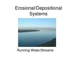
Rivers & Streams • River system –network of groundwater & streams that come together to form a system. • Drainage Basin- area of land from which a stream or river collects runoff. • The Mississippi River drainage basin is the largest in the United States
Young River • Flows swiftly through a narrow valley. • May have rapids & waterfalls. • Erodes the bottom faster than the sides. • “V” shaped valleys
Mature Stream • Flows smoothly through the valley. • Erodes more on the sides. • Forms meanders & oxbow lakes. • Carves a flat, broad valley floor called a floodplain.
Old Stream • Flows smoothly through a floodplain it has carved.
flood plain meanders oxbow lake valley wall
Delta – fan shaped area formed by sediments that are deposited as water empties into an ocean or lake. • Alluvial Fan – fan shaped area formed by sediments that are deposited as water empties from a mountain valley onto a flat open plain.
Groundwater • Groundwater is water that soaks into the ground and collects in the pores of the underlying soil. • Soil and rock are permeable if water can pass through the pore spaces. (Sandstone) • Soil and rock are impermeable if water can not pass through the pore spaces. (Granite) • Aquifer – a layer of permeable rock that lets water move freely. • Zone of Saturation : area where all the pores are filled with water. • Water Table : upper surface of the zone of saturation.
Aquifer Zone of Saturation Zone of Aeration Water Table
Wells are used to pump groundwater from an aquifer to the surface. • Artesian wells – wells that don’t require a pump because the water is under pressure. • Spring – free flowing water because the water table is so close to the surface. • Geyser – hot spring that erupts peroidically, shooting water & steam into the air. The the
Caverns are formed by Carbonic acid dissolving limestone rock, thereby enlarging cracks to form chambers. • Stalactites– Calcium carbonate deposits that hang from a cave’s ceiling. • Stalagmites – Calcium carbonate deposits that form on a cave’s floor.
Other Features: Soda Straws Columns Cave Popcorn Draperies Cave Pearls
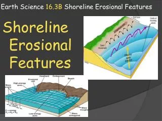
Ocean Shoreline • Shoreline Forces • Waves pound against pound against shores. • Currents move sediments along the shoreline. • Tides carry sediment out to sea & bring in new sediment.
Rocky Shorelines • Rocks & cliffs • C. Sandy Beaches • Beaches –deposits of sediments parallel to the shore. • Barrier Islands – fragile sand deposits that parallel the shore but are separated from the mainland.