Download
1 / 40
400 likes | 598 Views
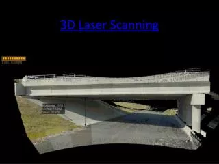
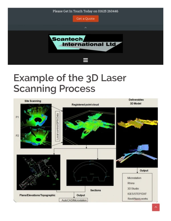
3D Laser Scanning Beyond the Project. Ron Singh, PLS Chief of Surveys/Geometronics Manager Oregon Department of Transportation SPAR Conference Houston, Texas 17 April, 2012. Target Audience Software Developers Hardware Manufacturers Service Providers Educators.

E N D
3D Laser ScanningBeyond the Project Ron Singh, PLS Chief of Surveys/Geometronics Manager Oregon Department of Transportation SPAR Conference Houston, Texas 17 April, 2012
Target Audience Software Developers Hardware Manufacturers Service Providers Educators This presentation will discuss the various elements of highway engineering automation and propose full utilization of information rich 3D point cloud data - beyond the project and into the life cycle management of the highway corridor.
Agenda Future Transportation Engineering Automation Vision Future Uses for Laser Scanning
Future Transportation a peek into the future 5 minutes
Future Transportation Issues Expected Problems: Possible Solutions: • Increase Mass Transportation • Develop Alternative Fuels • Reduce Need for Mobility • Increase Highway Capacity • Develop Smart Cars and Highways • Re-think the meaning of • Increased Traffic • Increased Congestion • Increased Carbon Emissions • Increased Fuel Costs • Aging Driver - Safety • Aging Infrastructure • Urban Growth
Imagine the Year 2037 “If I would have asked my customers what they wanted, they would have said…a faster horse.” Henry Ford More Highways? More Lanes? Faster Vehicles? Safer Vehicles? Smarter Vehicles? Smarter Highways? Self Driving (autonomous) Vehicles?
Technology in Vehicles • USDOT’s 1997 Intelligent Vehicle Initiative (IVI) • Warn Driver • Recommend Control Actions • Take Temporary or Partial Automated Control in Hazardous Situations • Assist Driver • Increase Safety • Increase Efficiency • Increase Comfort • Luxury or Necessity?
Smart Vehicles… Science Fiction or Reality? • AdaptiveCruise Control • Collision Warning with Auto Brake • Driver Alert System with Lane Departure Warning • Live Traffic Information • Live Weather Information • Intelligent Parking • Streaming Entertainment Cruise Control Anti Lock Brakes Engine Monitoring Air Bags Dynamic Stability and Traction Control Anti Rollover GPS Navigation Backup Video Built-in Telephone Emissions Monitoring Tire Pressure Monitoring
Communication Eras Enabling Technologies One to One (Personal) One to Many (Broadcast Media) Many to Many (Social Media) Machine to Machine (Connected Cars)
Web Eras Enabling Technologies • 1st Generation - Information • News • Email • 2nd Generation - Participation • YouTube • Facebook • Twitter • 3rd Generation - Services • Cloud Computing • Learning Systems • Machine to Machine • Weather • Traffic
Tomorrow’s Vehicles …Autonomous Advanced Positioning and Navigation Lane Tracking Night Vision Assist Obstacle/Pedestrian Detection Dedicated Short Range Communications (DSRC) Highway to Vehicle Communication Vehicle to Vehicle Communication Situation Awareness Beyond Capabilities of Human Driver
Autonomous Vehicles Will not take away human control Reduce driver workload Reliance on on-board sensors Reliance on knowledge of highway geometry Combination of sensors and highway geometry
Autonomous Vehicle Reality Nevada Governor Signs Driverless Car Bill Into Law – June 2011 Provides that the Nevada Department of Motor Vehicles "shall adopt regulations authorizing the operation of autonomous vehicles on highways within the State of Nevada.“ Setting safety and performance standards Requires designated areas where driverless cars may be tested.
Enablers and Partners Technology Developers Automotive Manufacturers US Department of Transportation State Departments of Transportation
EngineeringAutomationVision 15 minutes
Factual information Numbers Characters Measurements Output from devices Used as a basis for reasoning and calculation Data
Contains information An actual product of writing or recording Intended to communicate or store collections of data Physical printed pages “Virtual" document in digital format Documents
Information The result of processing, manipulating and organizing data in a way that adds to the knowledge of the person receiving it.
Reactive Project-centric Approach Survey Maintain Design Construct
Design Paper Plans Present Project Development Surveys Basemap Construction Staking 100% As-Built Plans
Engineering Automation The Next Twenty Five Years… will be… All About Information! New Paradigm Data-centric Real-time Information Collaborative Engineering Highway Infrastructure Lifecycle Management Automated Construction Intelligent Vehicles and Highways
To Enable This Future Paradigm, we need: A “Disruptive Technology” is one that requires changes to long standing established processes. To accept disruptive technologies A complete transformation. To redefine the nature of our work, how it’s conducted, and what we consider final products. To demand standardized data formats To collaborate across government agencies and private businesses
Technology Implementation Future Technology Current
Technology Development Curve Accelerating. Lack of Standards. Errors. Technology Emerging. Slow to Adopt. Cautious. Stable Stable Stabilizing. Establishing Standards. Change Slowing. Disruptive Period Time
Key Concepts • Digital Data • Spatially Enabled (including non-spatial documents) • Reliable (quality control) • Readable (universal published file formats) • Secure (check-in, check-out, revision, privacy, security) • Retrievable (backed up) • Traceable (metadata) • Migrated Forward (media/format obsolescence) • Digital Signatures • Documents and Data
Key Concepts • Structured Data Exchange • Industry Standards • XML • Extensible and Archive-able Open Format • Engineering Data Management • Engineering Content Management • Collaboration • File Access Control • Traceable • Workflow Management • Review/Redline • Check-in Check-out
Key Concepts • Engineering Data Management (cont’d) • Version Control • Standards Checking • Archiving • Geospatial Search • Infrastructure Life Cycle Management • Develop and maintain engineering data for the life cycle of all highways • Asset Management • Collect Legacy Data • Capture Engineering Data as it is Created
Key Concepts • Post Construction Surveys • Replace As-Built Plans • Complete 3D Engineered Model • Dynamic Documents • GIS/Engineering Data Integration • On-Demand Assembly • Robust IT Infrastructure • Super Utility • No single point of failure could bring the system down • Wireless Communication
Key Concepts • Real Time Networks (active control) • Improved Coordinate System • Low Distortion Projections (today) • Earth Centered Earth Fixed Coordinates without Projections (future) • 3D Point Cloud Data • Industry Standards – ASTM E57 • Point Level Metadata • High Compression (Lossless) • Intelligent (classification, material, increased observables)
Key Concepts • High Resolution (vertical and oblique) Ortho-rectified Imagery • Full 3D/4D/5D Design • Visualization • Construction Automation • Construction Machine Guidance and Control • Inspection Tools • Enhanced use of GPS (RTN, IMU) • Remote Construction Site Monitoring • Materials Delivery and Certification
Proactive Data-centric Approach Construct Maintain Design Survey
3D Design Digitally Signed Data Future Digital Signature Project Development Surveys Virtual Site Machine Control Construction Staking 20% 80% Engineering Data Archive Digital Signature As-Built Survey
3D Laser ScanningFull Utilization 10 minutes
Technology Development Curve Accelerating. Lack of Standards. Errors. Emerging. Slow to Adopt. Cautious. Stable Stable Stabilizing. Establishing Standards. Change Slowing. Disruptive Period
Laser Scanning (Civil Engineering) Making it fit the old paradigm! Determining Uses. We’re somewhere here Disruptive Period Experimenting.
Point Clouds (for projects) • Full Utilization of Information Rich Point Clouds • From “BaseMap” to “Virtual World” • No Traditional (Triangulated) DTM • Critical 3D Objects: • Mathematically Modeled (geometric solid object) • Mesh Modeled (reality, imperfect, discreet objects) • 3D Feature Extraction ONLY Where Necessary for Design • Certified by Professional of Record
Point Clouds (as an asset) • Virtual Highway Corridors • Information Rich Point Clouds • Aerial and Oblique Imagery • Engineering Accuracy/Quality • Programmatic Approach (statewide, cyclic) • Updated by Project As-Built Post Construction Surveys
Point Clouds (as an asset) • Integrated w/GIS • Engineering Alignments • Right-of-Way Boundaries • Asset Inventory • Pavement Conditions • Replacement for Video Log • Safety Analysis • Accident Reconstruction Survey (streamline) • Oversize Vehicle Routing
Thank You! Ron Singh, PLS Chief of Surveys/Geometronics Manager Oregon Department of Transportation If a thirty-year projection sounds like science fiction, it may be wrong… If it doesn’t sound like science fiction, then it’s definitely wrong. Chris Peterson