Download
1 / 13
130 likes | 147 Views
Learn about Guyana's MRV system for forest carbon monitoring & reporting, with details on implementation progress, institutional arrangements, data requirements, and spatial data needs for effective reporting. Explore collaboration opportunities with international agencies to enhance MRV implementation.

E N D
MRV & Reporting Status& Related Space Data Needs Guyana Jagdesh Singh & Pete Watt
Introduction • The overarching framework for work on REDD+ in Guyana is provided by the Office of Climate Change, Office of the President • GFC as lead for technical REDD+ work in Guyana including MRV and RL development • Strong coordination across natural resources planning agencies through the Ministry of Natural Resources and the Environment • This results in sharing of data, results of MRVS etc. • The GFC has established a REDD Secretariat that oversees the implementation of REDD+ activities that include MRVS as well as other areas under FCPF • In delivering this mandate of technical REDD+ implementation, the GFC has nested within its institutional structure, the integration of related aspects of REDD+ such as forest carbon field measurements, GIS and RS mapping, etc. within the existing units that coordinate similar activities under the Commission’s SFM mandate. This allows for synergies to be established between core forestry activities and new and emerging REDD+ initiatives in Guyana.
Status of National MRV Implementation The aim of the MRVS is to establish a comprehensive, national system to monitor, report and verify forest carbon emissions and removals resulting from deforestation and forest degradation, and forest cover change. The MRVS is the basis for performance-based payments for avoided deforestation and forest degradation under a REDD+ framework.
Status of National MRV Implementation • 2011- Year 1 • Determining the forested area • Setting the 1990-2009 Change baseline • Accuracy of Mapping & Change 97% • 2012 – Year 2 • Degradation process implemented • Batch processing of 300+ RE tiles to a change product • Accuracy of Mapping & Change 97% • 2013 – Year 3 • 100% country coverage with RE • Integration of Shifting cultivation • Integration of Afforestation monitoring • Base mapping improvements / Automation • UNFCCC reporting run operationally
Institutional arrangements • Relevant work with World Bank, through the FCPF and exploring cooperation with UNREDD and FAO • Collaboration with international technical agencies such as WWF and CI • Implementation using guidance provided by IPCC and new developments at the level of UNFCCC in terms of discussions and decisions of the COP. • Maximum of 2 slides
Space Data Needs • Scope and timeline for implementation • Areas, wall-to-wall, dates • Required space data types • Data heritage and/or plans • Current challenges & obstacles where GFOI assistance may be most valuable
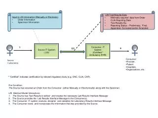
Guyana’s Annual MRVs Process Image order GIS datasets Aug – Dec 2012 Spatial data R&D Image processing & Analysis Method development & field testing Jan – Sept 2013 Public consultation External Audit / verification External Accuracy Assessment Oct – Dec 2013 Reporting: Guyana Report: http://www.forestry.gov.gy/news.html
Mapping Approach : Customised Tools Developed Remote sensing Tools GIS Tools • Developed based on 2 years operational research and customised to suit local working environments. • The result means standardised outputs and processes which allow effective reporting
Space Data Needs GFOI User Needs • Need access to appropriate data to meet reporting requirements • Coverage over high risk areas – i.e. tasked RapidEye & radar To do it • Formal coordination is required, Need a go to person, reaction time needs to be fast Observation • Its more complicated than just providing the data – each country is different. • Strict imaging requirements August –December • < 20% cloud cover, so high temporal coverage required • Wall to wall coverage • Resolution high enough to meet forest definition and reporting requirements; • Deforestation • Degradation • Shifting cultivation < 1 ha • Forest harvesting extent < 1 ha MMU • Afforestation • Recent high resolution coverage to enable a robust accuracy assessment • Must be > 5m resolution and coverage sufficient to draw a unbiased sample from.
Image Coverage 2012 August 2012 August 2013 August-Dec 2012 2012 Persistent Cloud
Improvements – Accuracy Assessment In progress - Advantages • Provides random sample that covers forest and forest change • System adaptable to suit local conditions – i.e. cloud cover • low cost compared to space data
Thank you for your attention Jagdesh Singh Deputy Commissioner of Forests Guyana Forestry Commission 1 Water Street, Kingston, Georgetown, GUYANA, South America www.forestry.gov.gy Dr Pete Watt Indufor Asia Pacific Ltd Auckland City New Zealand www.indufor-ap.com