Download

1 / 6
60 likes | 136 Views
Technology & Development Supervised Learning (TDSL) opportunities offered through IIT-B CTARA Spring 2013. Single-village drinking water schemes in the Poshiir river watershed. contact: Adam Rausch ( rausch [at] berkeley [dot] edu ). Study Design (Goals).

E N D
Technology & Development Supervised Learning (TDSL) opportunities offered through IIT-B CTARA Spring 2013 Single-village drinking water schemes in the Poshiir river watershed contact: Adam Rausch (rausch [at] berkeley [dot] edu)
Study Design (Goals) • Uniquely identify each scheme • Confirm that scheme falls within study bounds • Identify any success and failure trends based on scheme characteristics • Identify other impacts of the scheme on local populations • Maintain a record of how research • was conducted • Protect those participating in the • study from adverse effects of • participation
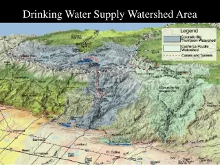
Study Area The Poshiir River watershed lies principally within the Northern section of Karjattaluka, Raigad, extending into Murbad and Ambernath, Thane. Geographically, the watershed begins in the Bhimashankar Hills, South of Siddhagad and North of Peth. Several forks combine before ultimately flowing into the Ulhaas River near Vangani. In the watershed map above, the black lines indicate taluka boundaries. The red is the Mumbai local, while yellow and green show roads. The East-flowing river at center is the Poshiir.
Scheme Selection From this area, we have selected ten single-village piped drinking water schemes for deeper study. Of these schemes, five are functional and five have failed. Each scheme studied will eventually constitute a case study to be viewed comparatively. Hopefully, this may illuminate factors that contribute to a scheme’s success. The map above shows the locations of the ten schemes within the study area. Three are located in the North fork watershed and the others within the Main fork watershed.
Study Design (Tasks) • Gather data from national scheme records • Gather data from local scheme records2 • Document habitation location • Observe and assess water sources • Measure water quality at select schemes1 • Observe and assess technical assets • Interview scheme end users2 • Interview scheme administrators2 • Focus of TDSL opportunity 1 • Foci of TDSL opportunity 2