Download
1 / 32
320 likes | 343 Views
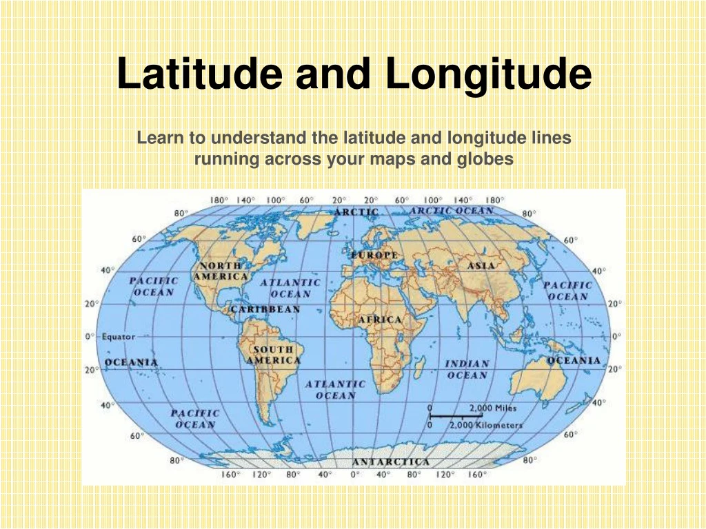
Latitude and Longitude Learn to understand the latitude and longitude lines running across your maps and globes. Where On Earth Are We?. The ancient Babylonians originally divided any circle or sphere into 360 degrees.

E N D
Latitude and LongitudeLearn to understand the latitude and longitude lines running across your maps and globes
Where On Earth Are We? The ancient Babylonians originally divided any circle or sphere into 360 degrees. There are 180 degrees between any two sides of a circle or sphere. The north and south poles are 180 degrees apart from one another, and both are 90 degrees from the equator. The equator is the imaginary line that is as far from the North Pole as it is from the South Pole.
Latitude The horizontal lines that circle the globe are called Lines of Latitude. • The major line of latitude is the equator at 0°.
Longitude The lines that run between the North and the SouthPoles are called Lines of Longitude, or meridians. • The major line of longitude is the PrimeMeridian at 0°.
Prime Meridian • The line at zerodegrees longitude is called the Prime Meridian. The prime meridian runs through the Royal Observatory in Greenwich, England. Meridians are counted east and west from the prime meridian, which is numbered zero degrees longitude. Prime Meridian 0 degrees longitude
Label the equator & Prime Meridian Prime Meridian equator
So, where is (0,0) • The origin point (0,0) is where the equator intersects the Prime Meridian. • (0,0) is off the western coast of Africa in the Atlantic Ocean.
Hemispheres • Everything north of the equator is in the Northern Hemisphere, while everything south of the equator is in the Southern Hemisphere. • The Western Hemisphere is west of the PrimeMeridian, while the Eastern Hemisphere is east of the PrimeMeridian.
Label the hemispheres northern, southern, eastern and western. N W E S
Label the four hemispheres north eastern, north western, south eastern, and south western. The E tells us that we’re east of the Prime Meridian. The W tells us that we’re west of the Prime Meridian. The N tells us we’re north of the Equator. The S tells us we’re south of the Equator.
180 150 120 90 60 30 0 30 60 90 120 150 180 165 135 105 75 45 15 15 45 75 105 135 165 90 80 70 E 60 50 40 30 F 20 10 0 10 G 20 30 40 50 60 H 70 80 90 Equator Latitude To get to the next line of latitude, you must move in which of two directions?
180 150 120 90 60 30 0 30 60 90 120 150 180 165 135 105 75 45 15 15 45 75 105 135 165 90 80 70 E 60 50 40 30 F 20 10 0 10 G 20 30 40 50 60 H 70 80 90 North South
180 150 120 90 60 30 0 30 60 90 120 150 180 165 135 105 75 45 15 15 45 75 105 135 165 90 80 70 E 60 50 40 30 F 20 10 0 10 G 20 30 40 50 60 H 70 80 90 Longitude To get to the next line of longitude you must move in which of two directions? Prime Meridian
180 150 120 90 60 30 0 30 60 90 120 150 180 165 135 105 75 45 15 15 45 75 105 135 165 90 80 70 E 60 50 40 30 F 20 10 0 10 G 20 30 40 50 60 H 70 80 90 East West
Directions 1. Label the equator & Prime Meridian. 2. Color latitude lines red. 3. Color longitude lines blue. 4. Plot 40°N, 73°W and label it Baldwin, NY
Where Are We? The United States is in the Northern and Western Hemispheres. Baldwin is 73° west of the Prime Meridian and 40° north of the equator. This is commonly expressed as 40°N, 73°W
Label the Latitude and Longitude 0º Longitude 45º E 90º N90º S 180º W 0º Latitude 45º N45º S135º W90º W45º W90º E135º E180º E
180 150 120 90 60 30 0 30 60 90 120 150 180 165 135 105 75 45 15 15 45 75 105 135 165 90 80 70 60 50 40 30 20 10 0 10 20 30 40 50 60 70 80 90 A B A: 250N, 1000W B: 300S, 1000E
LATITUDE ALTITUDE BASED ON THE ____________ OF _______________ POLARIS
POLARIS CAN ONLY BE SEEN IN THE HEMISPHERE NORTHERN
LONGITUDE BASED ON EARTH’S ROTATION
LONGITUDE EACH HOUR, EARTH ROTATES 15° (360°/24hrs)
HOW MANY TIME ZONES? 24 TIME ZONES, 15° APART
People on the same line of longitude have the same Local Time For example, New York & Florida
ANOTHER CHEESY SAYING EAST INCREASE Time is forward to all places to the east WEST LESS Time is backward to all places to the west
East Increase – West Less(1 hr per l5°) If it 9 p.m. at Position D, what time is it at position C? Position B? If it is 1 p.m. at Position X, at which location is the time 5 p.m.