Download

1 / 38
440 likes | 977 Views
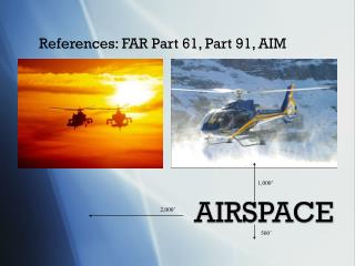
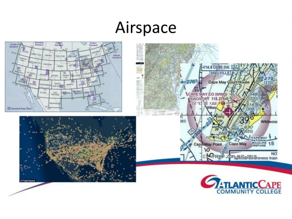
References: FAR Part 61, Part 91, AIM. AIRSPACE. 1,000’. 2,000’. 500’. Contents. General Information Class A Class B Class C Class D Class E Class G. Contents (Continued). Airport Advisory Areas Restricted Areas Prohibited Areas Warning Areas Alert Areas

E N D
References: FAR Part 61, Part 91, AIM AIRSPACE 1,000’ 2,000’ 500’
Contents • General Information • Class A • Class B • Class C • Class D • Class E • Class G
Contents (Continued) • Airport Advisory Areas • Restricted Areas • Prohibited Areas • Warning Areas • Alert Areas • Military Operations Areas • Controlled Firing Areas
Characteristics • Dimensions • VFR Weather • Equipment Requirements • Restrictions
General Information • Two categories of airspace: • regulatory (restricted & prohibited areas) • non-regulatory (warning areas, & MOAs) • Within these categories there are four types: • controlled (A, B, C, D, & E) • uncontrolled (G) • special use (warning, restricted, & prohibited areas) • other (airport advisory area)
Class A • Begins at 18,000’ MSL; extends up to and including FL 600 (excluding airspace less than 1,500’ AGL in Alaska). Extends out to 12 NM from the coast. • VFR Weather - N/A • Equipment - Mode C Transponder and two way radio. • No VFR or VFR on top authorized. • ATC clearance required.
Class A FL 600 18,000’ MSL Surface
Class B • Extends from surface or higher to specific altitudes individually tailored, but generally terminating at 10,000’ MSL. Resembles upside down wedding cake. • VFR weather 3 SM visibility and clear of clouds. • Mode C transponder inside & within 30 NM, and two way radio. • 250 KIAS limit below 10,000’ MSL, 200 KIAS in airspace underlying the Class B, or in VFR corridors within. • ATC clearance required.
Class A FL 600 18,000’ MSL Class B Surface
Class C • Dimensions are individually tailored but usually consist of a 5 NM radius core surface to 4,000' above the airport elevation, and a 10 NM radius shelf from 1,200' to 4,000' above the airport elevation, and a 20 NM radius outer area extending from the lower RADAR limits to the ceiling of the approach control’s airspace.
4,000’ AGL 10 NM Shelf 20 NM Outer Area 1,200’ AGL Core Class C (Continued) 5 NM
Class C (Continued) • VFR weather: 3 SM visibility & basic cloud clearance of 500’ below, 1,000’ above & 2,000’ horizontal. • Mode C transponder, & two way radio. • 250 KIAS below 10,000’ MSL, and 200 KIAS within 4 NM of the primary airport below 2,500’ AGL. ATC clearance required.
Class C (Continued) • VFR Arrival Communications: two way contact is established if the controller repeats your aircraft call sign. • Satellite Operations: departing an uncontrolled satellite airport that underlies Class C airspace, the pilot shall contact ATC as soon as possible after takeoff.
Class C (Continued) • Secondary Airports:where Class C overlies other Class D airspace portions of the overlapping Class C may be procedurally excluded when the secondary control tower is open.
Class A FL 600 18,000’ MSL Class B Class C Surface
Class D • Surface to 2,500' AGL (depicted in MSL) • Airspace based on Instrument procedures needed for that airport • VFR weather: 3 SM visibility & basic cloud clearance of 500’ below, 1,000’ above & 2,000’ horizontal, and 1,000' ceiling. • Two way radio. • Special VFR needed if Conditions are below 1000’ ceilings and or less than 3SM visibility. • To Obtain SVFR - Clearance from ATC and at least a private pilot Certificate
Class A FL 600 18,000’ MSL Class B Class C Class D Surface
Class E • Begins at 14,500’ MSL (excluding below 1,500’ AGL) and extends up to, but not including 18,000’ MSL. May also begin at the surface, 700’ AGL, 1,200’ AGL or other altitudes. • VFR weather (same as Class C, & D) except Above 10,000’ MSL - 5SM Visibility - 1,000’ above, 1,000’ below, & 1 SM horizontal. • No equipment requirements (VFR). • 250 KIAS below 10,000’ MSL.
Class E Class A FL 600 18,000’ MSL Class E 14,500’ MSL Class B Class C 1,200’ AGL E Class D 700’ AGL Surface
Glass G • Uncontrolled airspace from surface to the base of the overlying controlled airspace (700’, 1,200’, 14,500’ etc.). • VFR weather per 91.155(b) - • Below 1200’ AGL -Clear of Clouds • Above 1200’/Below 10,000’MSL - • Day:1SM - Night: 3SM • 500B, 1000A, 2000H • Above 1200’/Above 10,000’MSL • Day or Night - 5SM 1000B, 1000A, 1SMH • No equipment requirement.
Class E Class A FL 600 18,000’ MSL Class E 14,500’ MSL Class G Class B Class C E Class D Surface
Overlapping Airspace • When overlapping airspace designations apply to the same airspace, the operating rules associated with the more restrictive airspace applies: • Class A is more restrictive than B, C, D, E or G. • Class B is more restrictive than C, D, E, or G. • Class C is more restrictive than D, E, or G. • Class D is more restrictive than E, or G. • Class E is more restrictive than G.
Prohibited Area • Contain airspace within which the flight of aircraft is prohibited; established for security or other reasons associated with national welfare.
Restricted Area • Contain airspace within which the flight of aircraft while not wholly prohibited, is subject to restrictions. Activities in these areas must be confined due to the existence of unusual, often invisible, hazards to aircraft such as artillery firing, aerial gunnery, or guided missiles. • Must contact Controlling agency prior to entrance. • VFR? Squawk 1200.
Alert Area • Established to inform nonparticipating pilots of areas that may contain a high volume of military pilot training or an unusual type of aerial activity. All activity in an Alert Area shall be conducted in accordance with FARs.
Warning Area • Extend from 3 NM outward from the coast of the US and may contain activity that could be hazardous to nonparticipating aircraft. May be located over domestic or international airspace.
Controlled Firing Area • Contain activities, which, if not conducted in a controlled environment, could be hazardous to nonparticipating aircraft. CFA activities are suspended when RADAR, ground lookouts, or spotter aircraft indicate an aircraft may be approaching the area.
Military Operations Area • Established for the purpose of separating certain military training activities from nonparticipating IFR traffic. Since most military training activities necessitate acrobatic or abrupt flight maneuvers military pilots in MOAs are exempt from FARs prohibiting aerobatic flight. VFR pilots should contact FSSs within 100 miles of MOAs for operating hours.
Military Training Routs (MTR’s) • Definition: Routes used by the military to practice high-speed, low altitude maneuvers. Generally below 10,000’MSL and airspeeds greater than 250kts. • Status: IFR and VFR traffic are not prohibited from flying along the route, but should contact an FSS within 100 miles of the route for current activity • Charts: All MTR’s have been assigned a unique designator composed of two letters and either three or four numbers. • キThe two letters inform pilot of the type of operations that are performed along the route: • o VR– Visual Rules – See and avoid. • o IR– Instrument Rules – IFR separation • キThe number of digits informs the pilot of the altitude at which these operations will be conducted: • o 3 digits – both above and below 1,500’AGL • o 4 digits - at or below 1,500’AGL
Temporary Flight Restrictions (TFR’s) • Definition: May be issued by the FAA whenever an incident or accident has occurred that has potential for attracting a number of aircraft that may cause a hazard to those attempting to rescue or to those persons on the ground (for example: fire, earthquake, aircraft accident site, etc.) • FAA notifies Pilots of TFR’s through the issuance of NOTAM’s through FAA controlling facilities, military and airlines. • The NOTAM will contain information pertaining to the actual location, dimension, duration of the TFR and information of which aircraft are permitted to operate within the TFR. (generally 2000’agl and 2-3NM radius around the site) • Aircraft that may operate within the TFR • Aircraft aiding in disaster relief as approved by the FAA • IFR aircraft properly cleared by ATC.
Federal Airways • Definition: Provide routes between VOR’s/NDB’s to aid IFR traffic routes. • Two types of Federal airways • Colored airways: use NDB’s and 4 course radio ranges for navigation (no longer in use except in Canada and Alaska) • VOR airway system: use VOR’s (used in the US since 1950’s) • VOR airway system uses low altitude or Jet Routes • Low altitude airways are described in FAR 71 and utilize both high and low altitude VOR’s. They are assigned a distinct number identifier prefixed with the letter “V” (for example: V-105) • Low altitude airways extend from 1,200’AGL up to (but not including) 18,000’MSL and extended 4NM laterally on. • Jet routes extend from 18,000’ MSL up to and including FL450 and identified with a unique number and the prefix “J” (for example, J-105) • Charts: Depicted as light blue lines with their identifying number on sectional and L-charts.
Airport Advisory Area • The area within 10 SM of an airport where a control tower is not operating but where a FSS is located. Non-mandatory, but strongly recommended that pilot participate. • Not depicted on Charts.
Terminal Radar Service Areas (TRSA’s) • Definition: Originally established as part of the terminal radar program at selected airports. TRSA’s are not considered controlled airspace and are not governed by FAR 71. • The primary airport within a TRSA is considered to be class D airspace. The remaining portion of the TRSA (designed much like a miniature Class B airspace) is considered to be Class E, starting at 700’agl or 1,200’ AGL • VFR pilots are encouraged but not required to contact radar approach prior to entering class D airspace. VFR pilots must contact the tower prior to entering Class D. • Charts: Sectional: solid black lines and altitudes for each segment. Class D portion is blue dashed line.
Questions? • Within the US, the floor of Class A airspace is ___________ ? • 18,000’ MSL. • What are the VFR weather requirements for Class B airspace? • 3 SM visibility and clear of clouds. • What are the dimensions of Class C airspace? • 5 NM radius core from surface to 4,000’ AGL, 10 NM radius shelf from 1,200’ AGL to 4,000’ AGL, and a 20 NM radius outer area.
Questions? • When a control tower, located on an airport within Class D airspace ceases operation for the day, what happens to the airspace designation? • Class D airspace requires an operational control tower. When that tower ceases to operate, it reverts to Class E. Without weather reporting capability it reverts to Class G.
1,000’ 1 SM 5 SM Vis. 1,000’ Questions? • What are Class E VFR weather minimums above 10,000’ MSL? • 5 SM visibility, 1,000’ above, 1,000’ below and 1 SM horizontal.
Questions? • VFR flight is not authorized in a MOA? • True • False VFR pilots should exercise extreme caution in MOAs and contact any FSS within 100 miles of the area to obtain real-time information concerning the MOA hours of operation. Prior to entering an active MOA , VFR pilots should contact the controlling agency for traffic advisories.
Bonus Question • Where is a mode C transponder required? • Above 10,000’ MSL (excluding below 2,500’ AGL). • Within Class A, B, or C airspace. • Within 30 NM of a Class B primary airport below 10,000’ MSL. • Above Class C airspace below 10,000’ MSL. • Crossing the ADIZ of the United States.