Download
1 / 28
280 likes | 488 Views
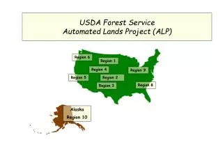
USDA Forest Service Automated Lands Project (ALP). Region 6. Region 1. Region 4. Region 9. Region 5. Region 2. Region 8. Region 3. Alaska Region 10. Automated Lands Project US Forest Service Alaska Region. Chugach National Forest. Tongass National Forest. 23,000,000 acres

E N D
USDA Forest ServiceAutomated Lands Project (ALP) Region 6 Region 1 Region 4 Region 9 Region 5 Region 2 Region 8 Region 3 Alaska Region 10
Automated Lands Project US Forest ServiceAlaska Region Chugach National Forest Tongass National Forest 23,000,000 acres 11,000 miles of shoreline 1700 townships 37,000 lands records
Automated Lands Project in Alaska • Purpose • Issues in the Forests • History • Spatial Structure • Data Conversion • Links to Other Information • What’s Done – What’s Next • Interagency Issues
Automated Lands Project US Forest ServiceAlaska Region Tongass National ForestYakutat Ranger District
MaintainSpatialRecords -UpdateAddDelete T28N R34E L I N K S WhatisALP? ProvideLibraryof Spatial LandsData to Users CornerRecords MasterTitlePlat U.S.Surveys Internet
What Issues are Driving the Automated Lands Project • State and Native Selections & Conveyances • Frequent Boundary Changes • Wilderness Areas and Monuments • Other Congressional Designations (LUD II) • Research Natural Areas • Geologic study areas • Forest and District Boundaries • And more…
Tongass National Forest Land Useand Neighbors BLM NPS Canada
Hubbard Glacier Geological Area Russell Fiord Wilderness City ofYakutat Other Forest Service lands Selected and Conveyed Lands Harlequin Lake Yakutat Forelands(LUD II)
History LOMS Land Ownership Management System UNIVAC, Ft. Collins S2K – Relational Database 1978 LOS Land Ownership Status System Alaska Regional Office Data General MV Oracle Relational Database 1989 LOS Land Ownership Status System Alaska Regional Office – I B M Oracle Relational Database 1999 ALP Automated Lands Project Alaska Regional Office – I B M Arc/Info Spatial Database Oracle Relational Database 2001
Lands Status Atlas Current method of storing spatial data
Automated Lands ProjectSpatial Structure • Structure based on PLSS (townships & sections) • Corner Identifier (PCCS-ID) • Arc Regions identify lands entities. • Each Arc region contains a unique Control Number that links to the same Control Number in Oracle.
CORNER ID’S Township 28s, Range 34eCopper River Meridian Alaska PCCS-ID’s Each section corner contains a pccs-id in the .NAT table. Each section is labeled with its southwest pccs-id. Each land polygon is given a Control Number based on pccs-id and other parameters.
Spaghetti Underlying Polygon Structure
Arc “Regions” allow using the same underlying polygons to create overlapping regions with unique identifiers that link to Oracle. DataConversion 500+Sections 4 ArcRegions ALP Oracle Database – 4 Records Control No Region Name Date Other…24360089 TWSHP 24s36e 05-may-1909 -------- 24360090 WILD RUSSELL 15-jan-1963 -------- 24360126 GEO HUBBARD 12-mar-1987 -------- 24360304 FOREST TONGASS 05-may-1909 -------- 24360126 24360089 24360304 GEO TWSHP FOREST 24360090 WILD
Linking Data to the Map Using Township, Range, Section and Acres T28N R34E Data Conversion
Linking Data to the Map Using Township, Range, Section and Global Locator T28N R34E
Control NumbersOnce an Oracle record is matched with an Arc Region a CONTROL NUMBER is assigned to both.
Links to Other Objects • Master Title Plat (BLM) • U.S. Survey (BLM) • Corner Records • Line Survey Status • Internet
MaintainSpatialRecords -UpdateAddDelete T28N R34E L I N K S WhatisALP? ProvideLibraryof Spatial LandsData to Users CornerRecords MasterTitlePlat U.S.Surveys Internet
Automated Lands ProjectWhat’s Next • FGDC Compliant Metadata • Product Distribution • Training • Data Stewardship • Database Maintenance
What are the Interagency Issues? • Are we all collecting the same corner ID? (PCCS-ID, GCDB) • Are there digital versions of US Surveys available? (AutoCAD, scanned…) • Should MTP’s and US Surveys reside in one place? (AGDC) • How will ALP, NILS, and SDMS fit together?