Download
1 / 36
360 likes | 387 Views
Learn about cyclogenesis in polar airstreams, including the stages of comma cloud development, associated vorticity maxima, and interactions with the polar front. Explore Polar Lows, their mesoscale structure, mechanisms, and rapid formation near ice margins.

E N D
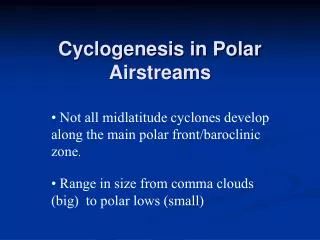
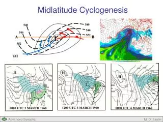
Cyclogenesis in Polar Airstreams • Not all midlatitude cyclones develop along the main polar front/baroclinic zone. • Range in size from comma clouds (big) to polar lows (small)
Comma Clouds • Convection and sometimes stratiform-type clouds organized into a comma-shaped patterns • Smaller than normal synoptic systems and on the cold side of the midlatitude jet stream. • Most apparent over the oceans during a period with high-amplitude, long-wave trough development
Generally of a smaller scale (500 to 1000 km) than classic midlatitude cyclones.
Usually associated with the region of positive vorticity advection (PVA) associated with a short-wave trough aloft.
Scale often grows in time, particularly as they move through a long wave trough
Three Stages of Comma Cloud Development • Incipient Stage • Two troughs: large scale one and other associated with developing comma • Appreciable baroclinicity with comma • Intensifying Stage • Convective elements grow in size and merge. • Size of system increases • Low center may appear • Stronger advections and front-like characteristics • Mature Stage • Large size and movement to the forward side of the long-wave trough. • Difficult to differentiate from a normal polar front cyclone
Associated with regions of appreciable baroclinicity (temperature gradient) on the cold side of a major baroclinic zone (“polar front”).
Often develop in conditionally unstable environments with lots of convection
Comma Clouds • Most apparent over oceans in winter, but can develop over land
1445Z/05 GOES-12 Visible 2 1
1745Z/05 GOES-12 Visible 2 1
2045Z/05 GOES-12 Visible 2 1
15Z/05 2 2
Some, But Not All, Associated with Lightning Strikes Jan 18-21 2010 Lightning in Yellow Nov 15-17 2009
Sea-level low-pressure center is sometimes found under the comma head, with a trough of low pressure under the trailing edge of the comma tail.
Sometimes the associated trough can develop frontal characteristics
There are a variety of ways for comma clouds, and their associated vorticity maxima, to interact with the main baroclinic zone/polar front
Instant Occlusion • The comma cloud/PVA maximum can excite the development of a wave on a preexisting front. • The comma cloud combines with the developing wave to form what appears to be a mature occlusion WITHOUT the usual occluded front evolution.
Why such a small scale? • Baroclinicity, latent heat release, and low stability appear to accompany most comma clouds. • Several studies (e.g., Gall 76 and Staley and Gall 76) suggest that baroclinic instability in concert with low stability in the lower troposphere could contribute to such small scales. • Needs more work.
Polar Lows Look somewhat like small hurricanes—spiral rain bands, cloud free eye
Polar Lows (also known as Arctic Hurricanes!) • Small scale: typically 300 to 800 km in size • Usually develop near the ice margin where relatively warm, open water is adjacent to ice fields or cold continents. • Thus, they develop in a region of very strong, low-level atmospheric baroclinicity. • Low-stability environment as cold air moves over warm water. Usually convective clouds are present, frequently in linear, cloud streets.
Polar Lows • Form rapidly when short-wave troughs aloft approach such baroclinic, unstable regions. • Favored locations: Bering Sea, Greenland, Norwegian and Barents Seas, Gulf of Alaska.
Polar Low Mechanisms • Because they look like hurricanes, some have suggested they grow by similar air-sea interaction mechanisms: • CISK (Conditional Instability of the Second Kind) • WISHE (Wind Induced Surface Heat Exchange) • Others have suggested that baroclinic instability in the presence of low stability is dominant. • Probably both mechanisms are important.