Download
1 / 27
270 likes | 468 Views
September 10, 2008. “GOES-R ABI Ocean Dynamics” Algorithm Design Review AWG Chair : Tim Mavor (STAR & IMSG). Ocean Dynamics Team. Chair : Tim Mavor (STAR & IMSG) AWG team : Robert Daniels (NCEP/OMB/OPC) Dave Foley (CoastWatch/West Coast Node) Charles Dong (UCLA)

E N D
September 10, 2008 “GOES-R ABI Ocean Dynamics”Algorithm Design ReviewAWG Chair : Tim Mavor (STAR & IMSG)
Ocean Dynamics Team • Chair: Tim Mavor (STAR & IMSG) • AWG team: • Robert Daniels (NCEP/OMB/OPC) • Dave Foley (CoastWatch/West Coast Node) • Charles Dong (UCLA) • John Ryan (Monterey Bay Aquarium Research Institute) • Qingzhao Guo (GOES-R AIT) • Stakeholders/Contributors • NOAA/NESDIS (Sasha Ignatov, GOES-R SST AWG) • NOAA/NESDIS (Jaime Daniels, GOES-R Winds AWG) • NOAA/NODC (Ken Casey) • NCEP/OMB (Real Time Ocean Forecasting System) • NOAA/CoastWatch (Kent Hughes) • NOAA/GhostNet (Bill Pichel)
Ground Segment F&PS Requirements[v1.0 05 May 08] • Currents & Currents:Offshore • Geographic Coverage • Currents: Full Disk and Mesoscale • Currents: Offshore: CONUS and Full Disk • Surface Product • Temporal Coverage: Day and night • Clear Conditions for threshold accuracy • Product Extent: Out to 67 Degrees LZA • Horizontal Resolution: 2km • Mapping Accuracy: 1km • Product Range: 0 to 7.2 km/hr, 0 to 360 degrees • Product Accuracy: 1 km/hr • Product Precision: 1 km/hr • Refresh Rate: 6hrs (3hrs for Offshore)
Proposed Changes to F&PS • Ocean currents • Drop distinction between “Currents” and “Currents: Offshore” • Include Direction Accuracy/Precision of 45 Degrees • Stratify Direction Accuracy/Precision by Ocean Current Speed • Ocean fronts from ABI • Legacy operational GOES-R product with no F&PS requirements • Potential Intermediate Product from Ocean Current Algorithm • Coverage: Full Disk (T), Hemispheric (G) • Surface Product • Horizontal Resolution: 4km (T), 2km (G) • Mapping Accuracy: 4km (T), 2km (G) • Measurement Range: Binary (yes/no) • Refresh Rate: 6hr (T), 1hr (G) • Data Latency: 60 min after SST (T), 15 min after SST (G) • Have provided Julie McNeil with F&PS, MRD and LIRD feedback
Proposed F&PS Requirements will support: • User community: • NCEP OMB • National Ocean Service • GhostNet • Marine Fisheries & Sanctuaries • Oceanographic research community • NODC • NOAA Mission Goal(s): • Weather and Water • Ecosystem • Climate Variability and Change • Safe, Efficient, and Environmentally Sound Transportation
Algorithm Capability Assessment • Present capabilities • There is no NOAA operational “stand-alone” satellite ocean current product. • Daily GOES SST Frontal product is operational using Edge Detection Method developed and tested within STAR • Possible capabilities • Ocean Currents Method 1 - Maximum Cross Correlation (MCC): Developed and tested with sequential polar IR-based SST imagery that can clearly show current using Maximum Cross Correlation (MCC) Method. • Ocean Currents Method 2 - Euclidean Distance (or Sum of Squared Differences): Feature tracking in atmospheric applications for deriving GOES winds. • SST Temperature Fronts – Sensitivity testing and analysis to improve operational product. • Shortfalls • Euclidean Distance algorithm untested for ocean currents. • GOES IR resolution (4km) is at margin of utility for sequential IR currents using MCC Method. • Both Ocean Current methods under consideration may under-estimate velocities along isolines (ie, the Gulf Stream) • Present operational frontal algorithms under-utilize temporal information (daily fronts only).
Algorithm Development Strategy • Study of Various Ocean Currents/Fronts Algorithms • Ocean Surface Currents • Evaluate Candidate Algorithms • Maximum Cross Correlation • Sum of Squared Differences (AMV) • Ocean Fronts • Legacy Operational Algorithm • Intermediate Product • Utilize GOES-R ABI features • Temporal • Spatial • Dependencies • SST AWG • Cloud Mask • Navigation • Simulation Study • Accuracy • Sensitivity • Timeliness • Testing and Validation
Testing and Validation • SST Analyses Data • OSTIA • Reynolds • RTG • RTOFS • Also Ocean Surface Currents for Validation • ABI Proxy Data • MSG SEVIRI Data • Best ABI proxy in terms of spectral and temporal feature. • Large amount of collections, easily accessible data • Current GOES Imager Data • Ground Measurements • CODAR • OSCAR • Drifting Buoys
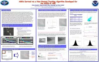
Ocean Surface Currents:Algorithm Example Maximum Cross-Correlation Courtesy: B. Emery
Development Strategy:Ocean Surface Currents • Two candidate algorithms • MCC Method • Sum of Square Distances (AMV) • Test with various input fields • SST • SST gradient • SST-sensitive bands • Ocean Fronts • Dependencies • Precise geo-location • Cloudmask
Ocean Surface Currents:Velocity patterns parallel to gradient? • MCC and AMV-like algorithm may not correctly produce velocities along isolines (ie, Gulf Stream) • Augment algorithms for along –isoline flow • Continuity preserving • Utilizes across isoline flow from other methods • Zavialov et al., JGR 2002
Development Strategy:Legacy Ocean Surface Fronts • Applied to GOES SST (Daily-Average) • Intermediate product for Ocean Currents? • GOES East/West Domain • Utilize Daily Averaged SST • Archived Daily Data From 2001 • OSDPD Operational: Dec 2006 • User Interaction via CoastWatch • AWG-2: Maturity Concerns • Additional Validation • End-to-End process
Testing and Validation: SST Analyses • Variety of SST Analyses • Varied temporal/spatial resolution • Advantage of Cloud-free data • Application of front algorithm to data • Algorithm sensitivity analysis • Part of GOES-R end-to-end validation • Daily comparisons • Climatologies • Drawbacks: limited in spatial domain
Testing and Validation: Navy Gulf Stream Product • Long Term Data Set • Part of algorithm sensitivity analysis • Part of GOES-R end-to-end validation • Frequent comparisons • Climatologies • Drawbacks • Limited spatial domain • Not necessarily daily
Summary • Recommendations • F&PS suggestions for Ocean Currents and Fronts • Outstanding Issues • Top Level Flow Chart Delivered (Apr ’08) • Draft ATBD Delivered and under Review (Aug ’08) • Continuing Algorithm and Test Plan Development (Aug – Oct ’08) • Detailed Flow Chart on schedule (Late Nov ’08’) • Algorithm Testing and Hosting (Nov – Dec ’08)