Download

1 / 22
220 likes | 403 Views
NOAA Hurricane Season Forecasting Atlantic and East Pacific. Dr. Gerry Bell Climate Prediction Center NOAA/ NWS. Joint Effort with National Hurricane Center/ NOAA/ NWS Hurricane Research Division/ NOAA/ OAR. Outline. Basis for NOAA’s Atlantic seasonal hurricane outlooks

E N D
NOAA Hurricane Season Forecasting Atlantic and East Pacific Dr. Gerry Bell Climate Prediction Center NOAA/ NWS Joint Effort with National Hurricane Center/ NOAA/ NWS Hurricane Research Division/ NOAA/ OAR
Outline • Basis for NOAA’s Atlantic seasonal hurricane outlooks • Major regions where hurricanes form and tracks • Total Atlantic seasonal activity • Conditions associated with above-normal hurricane activity • Climate links to the tropics – ENSO and Tropical Multi-Decadal Mode (TMM) • Atlantic/Pacific Hurricane Outlooks: procedures, verification, preliminary for May 2004 • 2003 east Pacific hurricane statistics • Summary
Basis for NOAA’s Atlantic SeasonalHurricane Outlooks Hurricane extremes are linked to known combinations of wind, air pressure, SST, and vertical wind shear over tropical Atlantic during August-October. 1984: Links established between Atlantic hurricane activity and ENSO: Indicates predictability at extended ranges (Dr. William Gray). 1992, 1996: Links established between Atlantic hurricane activity and decadal fluctuations in Atlantic Ocean temperatures, and West African monsoon.
Basis for NOAA’s Atlantic SeasonalHurricane Outlooks (cont’d) • 1998: NOAA releases first Atlantic hurricane outlook in August 1998 • Links established between Atlantic hurricane activity and tropics-wide multi-decadal mode (Chelliah and Bell 2004) • Tropical convection forces circulation associated with seasonal and decadal extremes in hurricane activity. • Combined ENSO + decadal impacts quantified, NOAA outlooks begin. • 2003: NOAA releases first experimental eastern Pacific hurricane outlook.
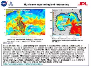
Major Regions Where Hurricanes Form Jun-Dec Aug-Oct Jan-Mar Jun-Oct Most Atlantic hurricanes develop from tropical storms that first form in the deep tropics. Conditions in this area determine whether the season will be active or inactive. The eastern Pacific has the highest concentration of hurricanes in the world.
East Pacific Region - 2003 Storm Tracks High concentration of activity in eastern Pacific
Atlantic Region Tracks - Major Hurricanes (winds >110 mph) Forming in Deep Tropics Active 24-Year Period 1955-1970, 1995-2002 Inactive 24-Year Period 1971-1994 MDR MDR 27 Major Hurricanes 15 Make Landfall as Hurricanes All hit as Major Hurricanes 67 Major Hurricanes 42 Make Landfall as Hurricanes 31 Hit as Major Hurricanes Above normal Atlantic hurricane seasons have high concentration of systems forming in deep tropics. They develop from African easterly disturbances during August-October.
Total Atlantic Seasonal Activity • Collective strength and duration of tropical storms and hurricanes in a given region • Measured by NOAA’s Accumulated Cyclone Energy (ACE) Index: • Energy index defined as sum of squares of 6-hourly maximum sustained wind speed for all systems while at least tropical storm strength. • The ACE index is: • - Highly predictable • - The Key forecast parameter for NOAA hurricane outlooks • - Used in defining hurricane season types
Total Atlantic Seasonal Activity (cont’d) Active: 1995-pres ACE = 134 13 TS, 8 h, 3.6 MH Inactive: 1970-1994 ACE = 65 9 TS, 5 H, 1.5 MH Active: 1950-1969 ACE = 114 10 TS, 6.5 H, 3 MH NOAA’s Accumulated Cyclone Energy (ACE) Index
Conditions Associated withAbove Normal Hurricane Activity Upper-level Easterlies Expand to Cover Tropical Atlantic Warmer SSTs Lower Surface Pressure Low Vertical Wind Shear Weaker Easterly Trade Winds August-October Higher Pressure Aloft Enhanced Tropical Easterly Jet (200-mb) Favorable mid level jet stream These conditions are conducive to tropical storm and hurricane formation as disturbances move westward from Africa into the low-shear environment (red area) of the tropical Atlantic.
Climate Links to the Tropics • Ocean surface temperature patterns and associated tropical convection are dominant forces for Atlantic hurricane extremes. These are strongly controlled by two climate factors: • El Niño/ Southern Oscillation (ENSO): Gray (1984) • Tropical Multi-decadal Mode (TMM): Chelliah • and Bell (2004)
ENSO: Jet-Stream Level Circulation Lower Pressure Higher Pressure High Shear Warm & Wet Lower Pressure Higher Pressure El Niño: Suppressed Activity in MDR La Niña: Enhanced activity in MDR Weaker Tropical Easterly Jet Higher Pressure Lower Pressure Low Shear Cool and Dry Higher Pressure Lower Pressure Stronger Easterly Trades ENSO captures western part of predictive signal
Tropical Multi-Decadal Mode (TMM): Active Atlantic Phase Warmer SSTs Lower Surface Pressure Low Vertical Wind Shear Weaker Easterly Trade Winds August-October Higher Pressure in Upper Atmosphere Enhanced Tropical Easterly Jet (200-mb) Favorable mid level jet stream Upper-level Easterlies Expand Westward TMM captures eastern part of predictive signal
Multi-Decadal Mode Signal in the Atlantic ACE index and Tropical SSTs
Multi-Decadal Atmospheric Signalover Tropical Atlantic • Above-Normal Seasons • Lower vertical wind shear critical for hurricane formation • Weaker low-level easterlies associated with northward shift of ITCZ and favorable mid-level flow • Mid-level cyclonic circulation provides energy to developing tropical disturbances. YEAR
Combined ENSO+TMM Activity Combination of El Niño and inactive phase of TMM is least conducive. Combination of La Niña and active phase of TMM is most conducive.
Atlantic Hurricane Outlooks: Procedures • Analyze and predict the combined tropical modes and their impacts. • Find analogue years having comparable phase and strength of the tropical modes. • Identify any additional conditions not linked to leading tropical modes. • Subjective blend items 1-3 into a Final Outlook.
Atlantic and East Pacific Hurricane Outlook Procedures – May 2004
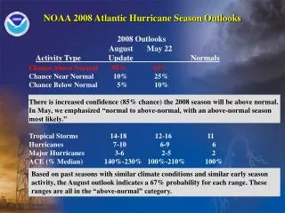
Atlantic Hurricane Outlooks - VerificationACE Index Forecast vs. Observed1998-2003 Issued in May 202 200 132 121 74 Issued in August 208 202 200 132 121 74 Observed Forecast Range Outlooks consistently predict accurate ACE range
Atlantic Hurricane Outlook Preliminary for May 2004 Season and 2004 2003 Climatological Activity Type Outlook Observed Mean Chance Above Normal 60% Above Normal Chance Near Normal 35% Chance Below Normal 5 % Tropical Storms 11-15 16 11 Hurricanes 7-9 6 7 Major Hurricanes 3-4 0 2 ACE Index: 95-140 172 94 ACE % of Median 110%-160% 200% 86%
2003 East Pacific Hurricane Statistics Season and Outlook Observed Climatological Activity Type June 11 Mean Chance Above Normal 10% Chance Near Normal 40% Chance Below Normal 50 % Below Normal Tropical Storms 11-15 16 15 Hurricanes 6-9 7 9 Major Hurricanes 2-5 0 4.5 ACE Index: 53-124 48.7 130 ACE % of Median 60%-110% 43.1% 113%
Summary • The amount of activity forming in the deep tropics determines the character of Atlantic hurricane season. • This activity is controlled by two dominant climate features: ENSO and the Tropical Multi-decadal Mode (TMM). • Both signals are related to anomalous surface temperatures and associated tropical convection. • ENSO and TMM, combined with current conditions, form the basis for NOAA’s hurricane outlooks. • The climate system provides for predictions of activity ranges, and likelihood of an above-, near-, and below-normal season. It does not indicate an exact numbers of systems. • Research is ongoing regarding the physical basis for eastern Pacific outlooks.