Download
1 / 36
360 likes | 626 Views
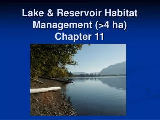
Lake DeSmet Reservoir. History Ownership and Capacity 2012 MODSIM Modeling Results Lake DeSmet Counties Coalition Joint Powers Board. Presented by: Edith Johnson-LaMeres, LDCC JPB Administrator. Lake DeSmet Storage Capacity. Total Storage Capacity 234,987 Acre–Feet (AF)

E N D
Lake DeSmet Reservoir History Ownership and Capacity 2012 MODSIM Modeling Results Lake DeSmet Counties Coalition Joint Powers Board Presented by: Edith Johnson-LaMeres, LDCC JPB Administrator created by: Edith Johnson-LaMeres, LDCC Administrator
Lake DeSmet Storage Capacity • Total Storage Capacity 234,987 Acre–Feet (AF) • High Water Elevation 4620 ft • Surface Area @ 4620 ft 3397 acres • Current Water Elevation 4609.98 ft (3/1/2012) • Surface Area @ 4610 ft 3265 acres • Storage @ 4610 ft 201,687 acre-feet
History • Creation & Location • Small natural body of water contained in a closed basin caused by burning coal deposits - now scoria hills. • Located about 10 miles north of Buffalo, Wyoming. • 1800’s • 1840 - Catholic missionary Father DeSmet chronicles describe a natural saline pond. • Salinity caused by lack of flushing flows into the basin.
History • 1900 - 1920’s • In 1907 Piney Creek and Clear Creek irrigators seized an opportunity to construct a dam near the northern end and built a canal from Piney Creek (Leiter Ditch). • New dam increased storage capacity and created a source of flushing flow into the basin. The high water line for this dam was 4544 feet.
History • 1940’s – 1950’s • John Rice, Lake DeSmet owner, and others began plans to develop Lake DeSmet as an industrial site. • Denver Post, February 22, 1952, stated: • “Cheap coal and abundant water may give Lake DeSmet region in northern Wyoming the inside track in the hotly contested race to get the first coal hydrogeneration plant to be built in the United States,” Bureau of Mines official Lawrence Skinner. • Reynolds Aluminum purchased the rights to Lake DeSmet, then transferred ownership to Texaco, Inc. in the 1970’s.
History • 1960’s & 70’s • 1967 Lake DeSmet Reservoir was reconstructed to hold 72,867 AF • 1973 Texaco purchased Lake DeSmet Reservoir • 1977 Texaco began process of enlarging the reservoir to its current capacity 234,987 AF with expectations of developing the extensive coal reserves. • 1978 Texaco began construction on the reservoir enlargement that exists today.
History • 1990 - 2000 • 1996 Texaco transferred ownership of the Clear Creek supply facilities and 62,199 AF of Lake DeSmet capacity to Lake DeSmet Energy Company • (later transferred in 2006 to M&M Ranch Acquisition Company – a subsidiary of MidAmerica Energy Holdings Company) • Texaco desired to divest themselves from Lake DeSmet due to merger with Chevron Oil Company. • Campbell, Johnson, and Sheridan Counties concluded this resource was too important to NE Wyoming to see it lost to downstream interests. • Three counties formed the Lake DeSmet Counties Coalition Joint Powers Board (LDCC JPB).
History • 2001 • Lake DeSmet ownership was transferred by Texaco to LDCC JPB • LDCC applied to Wyoming Water Development Commission (WWDC) for funding to: • Evaluate the condition of the facilities • Develop Master Plan to help guide operations • HKM Engineering completed the Lake DeSmet Master Plan and Reservoir Rehabilitation Plan in 2003 • MODSIM used to model the complex set of sources, diversion and storage water rights, and the multiple owners and users of Lake DeSmet Reservoir
History • 2003 – 2004 • LDCC applied to the WWDC for additional funding • Evaluate additional monitoring needs • Lake Engineering Consultants completed Phase 2 of the Lake DeSmet Reservoir Master and Rehabilitation Plan in 2004 • Campbell County requested to withdraw from the LDCC JPB • In 2004, the JPB agreement was amended. Johnson and Sheridan Counties remain as the governing bodies of the LDCC JPB.
History • 2005 - 2006 • LDCC applied for WWDC Level III Rehabilitation project money totaling $165,000. • Nearly 6,000 cubic yards of rip rap was lost along a portion of the face of the South Dam at Lake DeSmet due to severe winds and resulting wave action. • Rehabilitation project costs rose from $165,000 to estimated $1,430,000 as a result. • Preliminary discussions began with Wyoming Game & Fish Department regarding insuring and protection the recreational and fishery resources at Lake DeSmet. • Shoreline Protection Regulations development began.
History • 2007 - 2008 • LDCC JPB joined the City of Buffalo and SAWS to request funding from the WWDC for a Level I study. • Evaluate the complex water supply issues in Sheridan and Johnson Counties. • Collect reservoir water quality baseline information • MODSIM model developed to evaluate water supply and storage availability at Lake DeSmet • WWDC increased Rehabilitation funding to $1,430,000. • South Dam Rehabilitation: install riprap • Piney Creek Diversion Sediment Removal: remove sediment and debris from area upstream of the diversion dam after series of high runoff years.
History • 2009 - 2011 • Public Hearings regarding Lake DeSmet Management Options • South Dam Rehabilitation • Remove cut walls & Install rip rap • Piney Creek Diversion • Remove sediment from an area upstream of the diversion dam • By-pass gate repairs • Barkey Draw Boat Ramp Facility • Parking area and slope stabilization • Completed fall 2009 (WY Game & Fish) • MODSID Model updated jointly with coordination of T Cross T Ranch, M&M Ranch, and LDCC JPB. • Funding: T Cross T Ranch, LDCC JPB, and WWDC. • Emergency Action Plan developed • Engineer: DOWL HKM , Funding: WWDC, Homeland Security, & LDCC JPB • Web site developed: www.lakedesmet.org
Lake DeSmet Water Supply Sources • The principal sources of water include: • Piney Creek, major contribution • Clear Creek, pumped from Healy to Lake DeSmet • Shell Creek, only on-channel source • Rock Creek, minor contribution through M&M Ditch
Existing & Potential Uses • Municipal • Irrigation & Stock Water • Industrial • Hydropower • Recreation and Fish & Wildlife
Lake DeSmet Storage Capacity by Ownership (Acre –Feet) • 875 AF - Belus Land/Ballek Land & Livestock • 1,000 AF - T Cross T Ranch • 11,800 AF - Lower Clear Creek Irrigation District (LCCID) • 62,199 AF - M&M Ranch Acquisitions • 159,113 AF - LDCC JPB 234,987 AF - Total Storage Capacity
Lake DeSmet Modeling Results 2012Annual Firm Yield by Owner (AF) • 875 AF - Belus Land/Ballek Land & Livestock • 700 AF - T Cross T Ranch • 900 AF - Lower Clear Creek Irrigation District (LCCID) • 16,000 AF - M&M Ranch Acquisitions • 53,425 AF - LDCC JPB 71,900 AF - Total Firm Yield • Note: Annual Firm Yield is commonly referred to as the amount of water available each year during the driest period of record. The historical record used for 2011/2012 modeling was 65 years (1945-2010).
Lake DeSmet Annual Firm Yield by Ownership (AF) - with proposed Wyoming Game &Fish Lease • 875 AF Ballek/Belus (no change) • 700 AF T Cross T (no change) • 1,400 AF LCCID (increased 500 AF) • 20,000 AF M&M Ranch (increases 4,000 AF) • 41,525 AF LDCC JPB (decreases 11,900 AF) • 64,500 AF Total Firm Yield • (net change – 7,400 AFor 10.3% of total available yield) • Proposed lease of 5 junior storage permits owned by LDCC
Lake DeSmet Change in Annual Firm Yield with Proposed Lease to Wy. Game & Fish (AF)
Lake DeSmet Total Storage (AF) by Type of Use - withproposed Wyoming Game &Fish Lease
Lake DeSmet Total Storage (Percent) by Type of Use - withproposed Wyoming Game &Fish Lease
Annual Firm Yield of all LDCC JPB Owned Water by Type of Use
Annual Firm Yield of LDCC JPB Owned Water, by Type of Use, with proposed Game & Fish Lease
Modeling Results – Water Elevation Summary • Use of full annual firm yield, without proposed G&F lease: • 71,900 AF • 4550.5 ft minimum water elevation • 1735 acres surface water • 4609.7 ft maximum water elevation • 3258 acres surface water • Use of full annual firm yield, with proposed G&F lease: • 64,500 AF • 4569.1 ft minimum water elevation • 2280 acres surface water • 4611.1 ft maximum water elevation • 3280 acres surface water
Lake DeSmet - MODSIM2012 Modeling Results Summary • The firm yield of Lake DeSmet is approximately 71,900 AF. • The firm yield of Lake DeSmet is 64,500 AF, with the proposed lease to Wy. Game & Fish. • The proposed lease with Wy. Game & Fish, LDCC JPB, Johnson Co., and Sheridan Co. increases the firm yield available for Lower Clear Creek Irrigation District (LCCID) and M&M Ranch. • If the proposed recreational, non-consumptive use lease with the Game & Fish is secured, 50,600 acre-feet of firm yield remains available for future municipal, industrial and other development needs(30,600 acre-feet held by LDCC).
Lake DeSmet Reservoir2012 Modeling Conclusions Historical streamflow records for the last 65 years (1945 – 2010) and extensive alternative modeling indicate: Lake DeSmet Reservoir has sufficient water to meet foreseeable future municipal, industrial or other development needs, while protecting the existing fish, wildlife, and recreational uses at the lake.
Upcoming Events – LDCC JPB • Public information sessions to review and discuss 2012 Lake DeSmet modeling results. • Possible solicitation (RFP) – seeking potential interest in portions of LDCC JPB storage water. • Public Hearings in Johnson and Sheridan Counties regarding the proposed lease with WY Game & Fish. • Development and Public Hearings for Shoreline Protection Regulations. • Events posted and comments received at LDCC JPB website: www.lakedesmet.org
Lake DeSmet Counties Coalition Joint Powers Board • Administration • Amber Irby, Administrative Assistant • Edith Johnson-LaMeres, Administrator • Office: LDCC JPB 133 W. Burkitt Street Sheridan, Wyoming 82801 307-674-6906 www.lakedesmet.org
Lake DeSmet Counties Coalition Joint Powers Board • Members • David Garber, Chairman • R. Tracy Rhodes, Vice Chairman • Lucas Todd, Treasurer • Bob Rolston, Secretary • David Clarendon, Member at large • Delbert Eitel, Member at large
Consultants • Gary Elwell – DOWL HKM • Gordon “Jeff” Fassett – HDR Engineering