Download
1 / 15
150 likes | 195 Views
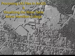
Learn how to process LiDAR files to create water table surface models, including converting LAS files to Multipoint, generating terrains and raster data, and interpolating the water table surface using ArcGIS 3D Analyst extension tools. Visualize and analyze water table surface data with 3D rotation in ArcScene.

E N D
.LAS files (Log ASCII Standard) • Not useable directly in ArcGIS • A single X-Y position can have multiple Z values • Must be converted to MultiPoint file
Converting LAS files to Multipoint 3D Analyst Extension Required Arc Toolbox > 3D Analyst Tools > Conversion > From File > LAS to Multipoint Zooming in you can see the individual data points that make up the file.
Terrain constructed in either a File or Personal Geodatabase from the multipoint file Right click feature data set > New > Terrain
DSM raster and hillshade Terrains cannot be hillshaded or used for raster analysis so a raster is created from the terrain 3D Analyst Toolbox > Conversions > From Terrain > Terrain to Raster Use Environments > General Settings > Extent > Same as Display to limit processing area
Reprocessing for “bare earth” Last returns can be used to construct a “bare earth” DTM of the scene, removing vegetation and some cultural features such as buildings and cars.
Using the swipe tool in ArcMap allows comparison of the DSM (left) and DTM (right).
Draping orthophotos on bare earth LiDAR ArcScene, part of 3D Analyst extension, allows 3D visualization. Orthophoto mosaic from NYS orthophotography program with base elevations set to bare earth LiDAR DTM
Monitor well locations Point shapefile from GPS coordinates of wells with base heights mapped to LiDAR bare earth
Building the water table surface data set Extract elevation at well positions from LiDAR DTM using Spatial Analysts Tools Spatial Analysts Tools > Extraction > Extract Values to Points Values added to attribute table as RSATERVALU Add additional fields for water depth in feet, water depth in meters and water surface elevation. Water depths in feet are entered manually, other values are calculated using field calculator.
Interpolating the water table surface 3D Analyst Tools > Raster Interpolation > IDW Z value is Water_elv Other interpolation methods can be tried as well. Surface can be contoured, but best visualization is achieved by adding the surface to ArcScene.
3D rotation in ArcScene allows the water surface to be viewed from multiple angles