Download
1 / 3
30 likes | 145 Views
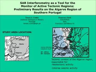
SAR I nterferometry as a Tool for the Monitor of Active Tectonic Regions: Preliminary Results on the Algarve Region of Southern Portugal. N. Teresa A. Cunha Instituto Geológico e Mineiro Portugal teresa.cunha@igm.pt. Francesco Sarti ESA/ESRIN Italy Francesco.Sarti@esa.int. 5. 5.

E N D
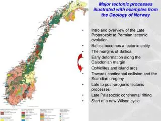
SAR Interferometry as a Tool for the Monitor of Active Tectonic Regions: Preliminary Results on the Algarve Region of Southern Portugal N Teresa A. Cunha Instituto Geológico e Mineiro Portugal teresa.cunha@igm.pt Francesco Sarti ESA/ESRIN Italy Francesco.Sarti@esa.int 5 5 0 0 40 40 STUDY AREA LOCATION: 4 4 5 5 Iberia EU 5 5 3 3 4 4 Portugal Açores-Gibraltar transform fault 4 4 AF AF - Africa EU - Eurasia Algarve .2 .2 3 3 • Tectonic context of the Algarve region, responsible for: • Neotectonic activity • Intense seismic activity 4 35 35 4 4 0 0
OBJECTIVES and TECHNIQUES DIFFERENTIAL SAR INTERFEROMETRY was applied, in the attempt to detect active movement along neotectonic faults, considering long time intervals between two different radar images up to 5 years in order to cope with slow deformation. Use of both ascending and descending ERS1 and ERS2 acquisitions to form interferometric pairs with time intervals of 2, 3 and 5 years. In order to eliminate atmospheric artifacts we used a methodology tested in CNES for the detection of urban subsidence in Paris: complex correlation between interferograms (Fruneau B., and Sarti, F., 2000) can evidence stable fringe patterns between two different interferograms Topographic fringes were modeled and eliminated by means of a digital terrain model DTED level 1 with 100-m horizontal grid.
RESULTS Existence of stable fringe patterns on independent interferograms, interpreted as a vertical movement of about 0.5-0.6 cm per year, detected by differential SAR interferometry and complex correlation Superposition with Seismicity map and Neotectonic map reveals good correlation: most interferometric structures are perfectly aligned with some of the active faults recognized in the Algarve region and coincide with halos of seismicity concentration Field studies and ground truthing need to be applied to the areas corresponding to the detected interferometric structures in order to give further evidence of active tectonic movement. If confirmed by field studies, ERS SAR interferometry will prove once more to be a useful tool in active tectonic studies, both for the location of potential active zones and for the quantification and extension of active tectonic deformation, thusopening the way to operational monitor of the Algarve region by means of ENVISAT ASAR interferometry