Geogrid assignment answers and discussion
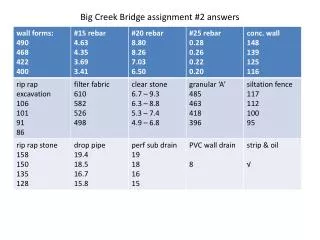
Geogrid assignment answers and discussion. ATM 419/563 Spring 2019 Fovell. Results. Specified resolution = 48 km. Lambert1. Lambert2. Polar. Mercator. ‘ Lat-lon ’ projection.


Geogrid assignment answers and discussion
E N D
Presentation Transcript
Geogrid assignment answers and discussion ATM 419/563 Spring 2019 Fovell
Results Specified resolution = 48 km
‘Lat-lon’ projection • WRF-ARW also permits a ‘lat-lon’ (cylindrical equidistant) projection that can be used for regional (e.g., non-global) domains. It’s a little trickier to use. • Modifications for namelist.wps • map_proj = ‘lat-lon’ • dx, dy need to be specified in degrees instead of kilometers • degrees ~ kilometers/111.11 • Need to move computational (as opposed to real) pole location (pole_lat) to minimize map distortion. For N Hemisphere: • pole_lat= 90.0-ref_lat • The standard longitude is antipodal to its usual value to orient the map the way you expect • stand_lon = -1*ref_lon
Lat-lon with pole_lat=41.4 Mapfac_m: min 1.0 max 1.02439 (very competitive with Lambert)
Plots using python Using wrf-python