Download
1 / 23
230 likes | 327 Views
Discover how collaborative green infrastructure planning in the Land-of-Sky Region improves environmental outcomes by linking diverse communities and resources. Learn about the challenges and goals of the project, partnerships involved, and the approach taken for sustainable development. Gain insights into the importance of natural resources, wildlife habitat, and biodiversity in the region. Explore the process of identifying high-value indicators and developing a regional green infrastructure network to protect critical ecosystems and enhance the quality of life. Join the webinar session to delve deeper into sustainable land use and transportation planning for a greener future.

E N D
Linking Lands and Communities in the Land-of-Sky Region Eco-Logical Webinar – “Green Infrastructure and Transportation Planning to Improve Environmental Outcomes” July 24, 2012 www.linkinglands.org Linda Giltz, AICP, Senior Planner 828-251-6622 lindag@landofsky.org
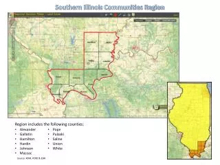
Land-of-Sky Region ~~~~~~~~~ Western North Carolina
Challenges Related to Growth/Development Land-of-Sky Region Population • Fragmentation of large parcels and habitat – affecting farms, forests, business/industrial sites • Loss of scenic quality • Sedimentation; water quality issues
Linking Lands and Communities – Project Goals Bring together a diverse group of people to explore common values and identify opportunities to work together to maintain our valued resources; Identify where the most valuable natural resources are located and how they might be interconnected; Produce a set of tools and resources for a variety of users, to make more informed land use and development decisions.
Project Partners Appalachian Sustainable Agriculture Project (ASAP) Appalachian Trail Conservancy Friends of DuPont State Forest NC Wildlife Federation Open Space Institute RiverLink Southern Appalachian Forest Coalition Southern Environmental Law Center Sustainable Big Ivy WNC Green Building Council Western North Carolina Alliance Buncombe County Buncombe County Greenways and Trails Commission Buncombe County Soil & Water Conservation District City of Asheville City of Hendersonville Transylvania County Blue Ridge Forever Carolina Mountain Land Conservancy Southern Appalachian Highlands Conservancy Asheville Convention and Visitors Bureau The Biltmore Estate Mountain Council for Accountable Development Self Help Credit Union/Self Help Ventures Fund Sustainability Strategies, LLC Blue Ridge National Heritage Area Blue Ridge Parkway Natural Resources Conservation Service U.S.D.A. Forest Service Southern Research Station U.S. Fish & Wildlife Service NC Cooperative Extension – County Offices NC Department of Agriculture NC Department of Environment and Natural Resources NC Division of Community Assistance NC Division of Forest Resources NC Farm Bureau NCSU Mountain Horticultural Crops Research & Ext Center NC Wildlife Resources Commission Mars Hill College RENCI @ UNC Asheville UNC Asheville Warren Wilson College
FundingPartners The Community Foundation of Western North Carolina Blue Ridge National Heritage Area Federal Highway Administration RENCI at UNC Asheville Z. Smith Reynolds Foundation Lyndhurst Foundation Wildlife Conservation Society National Association of Regional Councils (NARC)
Green Infrastructure Planning Approach • Nationally recognized collaborative method for land use planning • Community- and science-based approach • Focus on systems and networks • Need for planning, design, investment, maintenance, management
Our Economy needs Healthy Natural Systems • Sustain lands for forestry & agriculture • Provide scenic views, trails, parks, and cultural areas that attract residents and visitors • Offer natural and restored green settings for growth and development • Attract and retain businesses and jobs, provide entrepreneurial opportunities
What are the most important natural and land-based resources in the region? • Water and water quality • Farming and forestry • Cultural heritage • Scenic views • Recreation • Wildlife habitat and biodiversity
Resource Assessments Purpose:To identify lands in the Land-of-Sky (LOS) region valued for their contribution to: • Water quality • Agriculture • Wildlife habitat & biodiversity Developed by: Working groups of partners from around the region and facilitated by LOS staff. • Raster based modeling (30-meter pixels) • Most current data available • Region-wide data
High Value Indicators: • Land Cover – Vegetation Type • Most productive soils • Presence of an existing farm/forest operation • Highest ranking lands (10) have productive soils AND • forest or cropland vegetation
The region was divided into 3,525 sub-watersheds; each assessed on: • Land use / land cover • Stream quality • Elevation • Level of protection
Wildlife habitat patches • Large core area; compact and tightly clustered patches Priority habitat types: • > 4,000 feet • Floodplain Forests, Riverine and Aquatic Communities Biodiversity Sites: • Significant Natural Heritage Areas (aquatic and terrestrial) • Native Brook Trout streams; Outstanding Resource Waters • Streams with Excellent bioclass ratings
Developing the Regional Green Infrastructure Network • Identifying the hubs – highest valued lands from each assessment • Combining the assessments • Identifying the corridors – connect ecosystems and habitats to enable plants, animals, and ecological processes to move between hubs
Final Green Infrastructure Network Combined Resource Hubs + Wildlife Habitat & Biodiversity Corridors
Outcomes from the Linking Lands Project • Maps that identify lands that most contribute to important ecosystem services • A new set of tools and resources that can inform land use planning at multiple scales • Relationships amongst a diverse group of regional leaders • Increased awareness of the link between healthy communities and healthy ecosystems
Project website: www.linkinglands.org Assessments Maps Documentation On-line, easy-to use tool - http://gis.buncombecounty.org/LinkingLands/
Many Uses for Many People • Land Owners and Developers • Site planning and design • Land stewardship • Land Trusts and other Non-profits • Prioritizing conservation projects • Farmland Preservation • Students • Place-based learning • Hands-on projects
Governmental Uses of Tools • Local Governments • Development review and site design • Enhance/support city/county planning • Identify opportunities for parks, greenways • State and Federal Agencies • Transportation planning and mitigation • Justify funding for conservation or management • Identifying areas for conservation and assisting with community planning along the Blue Ridge Parkway • Connecting state and national parks to other lands with valuable natural resources
Priority Transportation Projects with Green Infrastructure Network – for Land-of-Sky RPO
Development Review & Site/Project Design Green Infrastructure corridors around Weaverville
Other Uses and Future Plans Data and maps being used in current project that is looking at and planning for growth and development – GroWNC (www.gro-wnc.org) Sharing methodology with adjacent regions to hopefully expand GI network Continue to share information and benefits – locally, regionally and nationally – APA, NADO-sponsored webinar, NARC conference
Linking Lands and Communities in the Land-of-Sky Region Project website: www.linkinglands.org Online map tool: gis.buncombecounty.org/LinkingLands/ Land-of-Sky website: www.landofsky.org