Download
1 / 24
240 likes | 408 Views
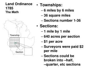
Quiz on U.S. Land Ordinance of 1785 + General items on map + GPS vs. GIS. Quiz on block day Pgs. 10 and 11 To General stuff on hand out add meridan and Prime M eridan , International Date L ine, equator (parallel) North/south (meridian) East/West (base line). Happy September. Round 1

E N D
Quiz on U.S. Land Ordinance of 1785+ General items on map + GPS vs. GIS • Quiz on block day • Pgs. 10 and 11 • To General stuff on hand out add meridan and Prime Meridan, International Date Line, equator (parallel) • North/south (meridian) East/West (base line)
Happy September • Round 1 • Whip around-introduce yourselves to one another • Round 2 • Tell the group about something interesting you experienced this weekend • Round 3 • Whip around-Compare/contrast your vocabulary and discuss K.I. #1 • Questions?????
Have a page titled “Journal/Warm-ups”You may put more than one entry on each page • What are the goals of psychology?
Goals of psychology • Describe • Explain • Predict • Influence…………Behavior
Spatial Geography • Where is it? • Why there? • Why are the distributions as such?
Globalization and local diversity • People are being pulled in opposite directions. • Modern communications and technology have fostered globalization, pulling people into greater cultural and economic interaction. • At the same time, people are searching for more ways to express their unique cultural traditions and economic practices. • Tensions between these simultaneous geographic trends underlie many of the world’s problems.
Look at page #3 in your book • What do you see? • What do you know about what happened here?
Look at figure 1-1 on page 5 • What do you notice? • What are some implications?
Place and Region • Place • A specific point on Earth distinguished by a particular characteristic • Every place occupies a unique location, or position, on Earth’s surface. • Region • An area of Earth distinguished by a distinctive combination of cultural and physical features.
Scale and space • Scale • The relationship between the portion of Earth being studied and Earth as a whole. • Individual to the entire Earth • Global-scale patterns and processes • Space • The physical gap or interval between two objects • Many objects are distributed across space in a regular manner, for discernable reasons
North America at Night - Regional Scale Online: 6/27/2006 - http://www.nasa.gov/images/content/49261main_usa_nightm.jpe
Your State at Night - Local Scale Online: 6/27/2006 -http://antwrp.gsfc.nasa.gov/apod/image/usanight_dmsp_big.gif
Larger Scale Level 4 Analysis - 1)Where - based on what you see in map 2) Patterns 3)Why? 4) What if the scale changes?
Smaller Scale Level 4 Analysis - 1)Where - based on what you see in map 2) Patterns 3)Why? 4) What if the scale changes?
Which scale is larger scale, why? • 1:10,000 • 1:10,000,000
Connections • Connections • Relationships among people and objects across the barrier of space • Why/how connections occur
Page 6 and 7 • Notice the world map on page 6 and 7 • AP Human geography expects that you are very familiar with the world map and doesn’t spend a lot of time teaching it to you. • How will you meet this expectation?
Projection • Sphere or globe flattened • 3-dimentional to 2-dimentional • Shape can be distorted • Distance between two points may become increased or decreased • Relative size of different areas may be altered, so that one area may appear larger than another but is relativel
What are the differences between GPS, GIS, and remote sensing?
GPS • Global Positioning System • A system that accurately determines the precise position of something on earth • GIS • Geographic Information System • Involves storing information about a location in layers. Each layer represents a different piece of human or environmental information
Remote Sensing • The acquisition of data about Earth’s surface from a satellite orbiting Earth or from other long-distance methods