Download
1 / 21
210 likes | 332 Views
Source Control in the Duwamish Waterway Seattle Public Utilities October 30, 2009. Today’s Presentation. Business Inspections Source tracing/characterization Compare Lower Duwamish Waterway site with East Waterway site source tracing results. Lower Duwamish Waterway Site. Storm drain basin :

E N D
Source Control in the Duwamish WaterwaySeattle Public UtilitiesOctober 30, 2009
Today’s Presentation • Business Inspections • Source tracing/characterization • Compare Lower Duwamish Waterway site with East Waterway site source tracing results
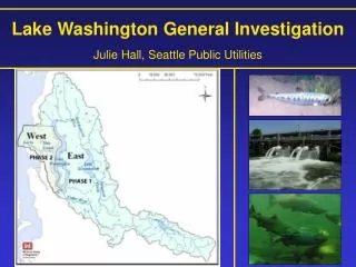
Lower Duwamish Waterway Site Storm drain basin: 8,900 acres 240 outfalls
Lower Duwamish Waterway Site Storm Drain Basin
Lower Duwamish Waterway Site Storm drain basin: 8,900 acres 240 outfalls Combined sewer service area: 20,000 acres 10 outfalls
Lower Duwamish Waterway Site Storm drain basin: 8,900 acres 240 outfalls Combined sewer service area: 20,000 acres 10 outfalls
Lower Duwamish and East Waterway Sites LDW Storm drain basin: 8,900 acres 240 outfalls Combined sewer service area: 20,000 acres 10 outfalls EW Storm drain basin: 805 acres 35 outfalls
Lower Duwamish and East Waterway Sites LDW Storm drain basin: 8,900 acres 240 outfalls Combined sewer service area: 20,000 acres 10 outfalls EW Storm drain basin: 805 acres 35 outfalls Combined sewer service area: 4,800 acres 3 outfalls
Lower Duwamish and East Waterway Sites Storm Drain Basin
SPU Business Inspections • Stormwater • Industrial waste • Hazardous waste • Spill prevention and control 2003-2009: LDW: 2,280 inspections EW: 720 inspections
SPU Source Tracing • Sediment traps • Inline grabs • Catch basins • Onsite at businesses • Public right-of-way (ROW)
Source Samples LDW (596): • 123 Onsite catch basins • 137 ROW catch basins • 158 inline grabs • 178 traps EW (95): • 46 Onsite catch basins • 23 ROW catch basins • 10 Inline grabs • 16 sediment traps
PCBs LDW EW >100,000 PCBs (ug/kg dw)
BEHP LDW Frequency EW Frequency BEHP (ug/kg dw)