Download

1 / 68
690 likes | 850 Views
Urban Geography. Chapter 9. Key Question:. When and Why did People Start Living in Cities?. Cities. City – a conglomeration of people and buildings clustered together to serve as a center of politics, culture, and economics. Urban:

E N D
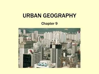
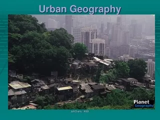
Urban Geography Chapter 9
Key Question: When and Why did People Start Living in Cities?
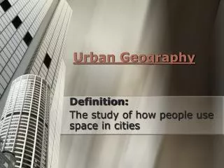
Cities • City – a conglomeration of people and buildings clustered together to serve as a center of politics, culture, and economics.
Urban: The buildup of the central city and the suburban realm – the city and the surrounding environs connected to the city.
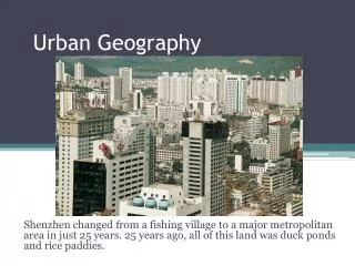
Shenzhen, China The Modern Process of Urbanization – a rural area can become urbanized quite quickly in the modern world
Shenzhen, China Shenzhen changed from a fishing village to a major metropolitan area in just 25 years. 25 years ago, all of this land was duck ponds and rice paddies.
Agricultural Villages • Before urbanization, people often clustered in agricultural villages – a relatively small, egalitarian village, where most of the population was involved in agriculture. About 10,000 years ago, people began living in agricultural villages
The First Urban Revolution Two components enable the formation of cities: 1. an agricultural surplus 2. social stratification (a leadership class)
Five Hearths of Urbanization In each of these hearths, an agricultural surplus and social stratification created the conditions necessary for cities to form and be maintained.
Five Hearths of Urbanization • Mesopotamia, 3500 BCE • Nile River Valley, 3200 BCE • Indus River Valley, 2200 BCE • Huang He and Wei River Valleys, 1500 BCE • Mesoamerica, 200 BCE
Indus River Valley Harappa and Mohenjo-Daro were two of the first cities of the Indus River Valley. - intricately planned - houses equal in size - no palaces - no monuments
Huang He and Wei River Valleys The Chinese purposefully planned their cities. - centered on a vertical structure - inner wall built around center - temples and palaces for the leadership class Terracotta Warriors guarding the tomb of the Chinese Emperor Qin Xi Huang
Mesoamerica Mayan and Aztec Civilizations Many ancient cities were theocratic centers where rulers were deemed to have divine authority and were god-kings.
Mesoamerica Between 300 and 900 CE, Altun Ha, Belize served as a thriving trade and distribution center for the Caribbean merchant canoe traffic.
Diffusion of Urbanization The Greek Cities by 500 BCE, Greeks were highly urbanized. • Network of more than 500 cities and towns • On the mainland and on islands • Each city had an acropolis and an agora
Athens, Greece the agora the acropolis
Diffusion of Urbanization The Roman Cities a system of cities and small towns, linked together with hundreds of miles of roads and sea routes. • Sites of Roman cities were typically for trade • A Roman city’s Forum combined the acropolis and agora into one space. • Roman cities had extreme wealth and extreme poverty (between 1/3 and 2/3s of empire’s population was enslaved)
The Roman Forum Aqueducts in Nimes, France
During the mercantile era, the cities that thrived were embellished by wealthy merchant families, who built ornate mansions, patronized the arts, participated in city governments, and supported the reconstruction of city centers. Genoa, Italy
The Second Urban Revolution A large scale movement of people to cities to work in manufacturing. Made possible by: 1. second agricultural revolution that improved food production and created a larger surplus 2. industrialization, which encouraged growth of cities near industrial resources
During the second half of the 20th century… Nature of manufacturing changed and locations changed, too. Many factories have been abandoned, creating “rust belts” out of once-thriving industrial districts. Duisburg, Germany
Archaeologists have found that the houses in Indus River cities, such as Mohenjo-Daro and Harappa, were a uniform size: each house had access to a sewer system, and palaces were absent from the cultural landscape. Derive a theory as to why these conditions were present in these cities that had both a leadership class and a surplus of agricultural goods.
Key Question: Where are Cities Located and Why?
Site * absolute location of a city * a city’s static location, often chosen for trade, defense, or religion. Situation * relative location of a city * a city’s place in the region and the world around it. Site and Situation
Trade area – an adjacent region within which a city’s influence is dominant. Trade area Green Country, Oklahoma
Rank-Size Rule: in a model urban hierarchy, the population of the city or town will be inversely proportional to its rank in the hierarchy. For example: largest city = 12 million 2nd largest = 6 million 3rd largest = 4 million 4th largest = 3 million
Primate City The leading city of a country. The city is disproportionately larger than the rest of the cities in the country. For example: London, UK Mexico City, Mexico Paris, France - the rank-size rule does not work for a country with a primate city
Central Place Theory Walter Christaller developed a model to predict how and where central places in the urban hierarchy (hamlets, villages, towns, and cities) would be functionally and spatially distributed. Assumed: • surface is flat with no physical barriers • soil fertility is the same everywhere • population and purchasing power are evenly distributed • region has uniform transportation network • from any given place, a good or service could be sold in all directions out to a certain distance
C = city T = town V = village H = hamlet Hexagonal Hinterlands
Sketch a map of your city or town and the cities or towns nearby. Make a list of goods and services available in each of these towns. Do the ideas about central places presented in this section of the chapter apply to your region?
Key Question: How are Cities Organized, and How do they Function?
Urban Morphology The layout of a city, its physical form an structure. Berlin, Germany With wall (above) And without wall (right) What does the urban morphology of the city tell us about the city?
Functional Zonation The division of the city into certain regions (zones) for certain purposes (functions). Cairo, Egypt Central city (above) Housing projects (right) What does the functional zonation of the city tell us about the city?
Zones of the City • Central business district (CBD) • Central City (the CBD + older housing zones) • Suburb (outlying, functionally uniform zone outside of the central city)
Modeling the North American City • Concentric zone model (Ernest Burgess) • Sector model (Homer Hoyt) • Multiple Nuclei Model (Chauncy Harris and Edward Ullman)
Edge Cities Suburban downtowns, often located near key freeway intersections, often with: - office complexes - shopping centers - hotels - restaurants - entertainment facilities - sports complexes
Urban Realms Model Each realm is a separate economic, social and political entity that is linked together to form a larger metro framework.
Modeling the Cities of the Global Periphery and Semiperiphery • Latin American City (Griffin-Ford model) • African City (de Blij model) • Southeast Asian City (McGee model)
Disamenity sector –very poorest parts of the city eg. the favelas of Rio de Janeiro, Brazil
Employing the concepts defined in this section of the chapter, draw a model of the city with which you are most familiar. Label each section of the city accordingly. After reading through the models described in this section, determine which model best corresponds to the model you drew and hypothesize why it is so.
Key Question: How do People Make Cities?
Powerful social and cultural forces shape the character of a city and create the cultural landscape of the city.