Download
1 / 33
330 likes | 440 Views
Explore the impact of El Niño on sea temperatures, fish populations, and atmospheric conditions. Learn about ENSO cycles, La Niña events, and other climate patterns affecting global weather.

E N D
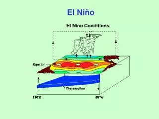
El Nińo: a disruption in the “normal” pattern in the Pacific Ocean.
Off the west coasts of continents, the Sea Surface Temperature is chilly. Fish love the cold water, especially anchovies.
The SST changes have really big consequences for the atmosphere.
This is the development of the most intense El Nińoever recorded in 1997-98.
So, what happens during El Nińo? The normal mean pressure features are these: 3. The Aleutian Low strengthens 2. Trade winds get weaker or reverse 1. The Subtrop High moves south or weakens
For January, 1998, this was the 1000 mb (surface) L H L H Mean values Departures from the 30-year mean (Anomalies)
At 250 mb, there were changes caused by the surface pressure and temperature anomalies Mean values Departures from the 30-year mean (Anomalies)
Look at the effect on the 250 mb wind (the Jet Stream!) Departures from the 30-year mean (Anomalies) Mean values The much stronger subtropical Jet Stream explains all the U.S. anomalies
The ENSO cycles vary in length and intensity ~ 6-18 months. There have been several big events in the last 20 years.
What is the current situation? El Nińo, La Nińa, or “neutral”?
Other circulation patterns and their effects NAO: North Atlantic Oscillation AO: Arctic Oscillation PNA: Pacific/North American (oscillation) PDO: Pacific Decadel Oscillation The figures shown are from www.nc-climate.ncsu.edu/climate/patterns
NAO (North Atlantic Oscillation) As the name tells us, this is a pattern located in the North Atlantic Ocean.
AO (Arctic Oscillation) Here we are just interested in the Arctic. From http://www.nc-climate.ncsu.edu/climate/patterns/NAO.html
Warm Phase PDO (Pacific Decadel Oscillation) Cold Phase
If both ENSO and the PDO are in the same phase, it is believed that El Niño/La Nina impacts may be magnified. Conversely, if ENSO and the PDO are out of phase, it has been proposed that they may offset one another, preventing "true" ENSO impacts from occurring (http://www.nc-climate.ncsu.edu/climate/patterns/PDO.html) The current PDO index is +0.38 (http://jisao.washington.edu/pdo/PDO.latest)