Download
1 / 2
20 likes | 140 Views
This study enhances the traditional Coastal Vulnerability Index (CVI) by incorporating unique parameters specific to small associated islands of Puerto Rico and the US Virgin Islands. Factors such as geomorphology, erosion rates, coastal slope, sea-level rise, vegetation, and storm frequency were considered. Field mapping was conducted on two islands to assess vulnerability. The study aims to provide a preliminary vulnerability assessment for small islands and refine methodologies for the larger region. The importance of studying coastal vulnerability on small islands, which can experience rapid changes over a small surface area, is highlighted.

E N D
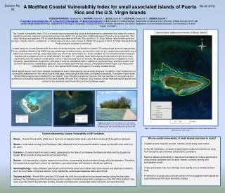
Session No. 92 A Modified Coastal Vulnerability Index for small associated islands of Puerto Rico and the U.S. Virgin Islands Booth #116 PERISON-PARRISH, Elizabeth M.1; RUNYAN, Ryann M. 2 ; BUSH, David M.3 ; JACKSON, Chester W.4 ; SIEMER, Kyle W. 5 (1) eperiso1@my.westga.edu, (2) rrunyan1@my.westga.edu, (3) dbush@westga.edu; (1,2,3) Center for Coastal Studies, Department of Geosciences, University of West Georgia 30118; (4) cjackson@georgiasouthern.edu, Department of Geology & Geography, Georgia Southern University, Statesboro, GA 30460; Department of Environmental Sciences, The University of Toledo, Toledo, OH 43601 The Coastal Vulnerability Index (CVI) is a formula that incorporates key physical and geomorphic parameters that shape the coast to determine potential response to projected sea-level rise (SLR). CVI studies have traditionally been focused on long coastlines. This study develops and applies a CVI for small islands associated with Puerto Rico and the U. S. Virgin Islands. Islands with significant ecologic, cultural, historic, recreational, or natural resource value were chosen. A USGS CVI analysis of the U. S. Virgin Islands National Park provided a template for this study. Coastal dynamics of small islands differ from that of mainland shores, and therefore a classic CVI analysis was deemed inappropriate. The six variables utilized by the USGS are geomorphology, shoreline erosion and accretion rates (m/yr), coastal slope (percent), rate of relative sea-level rise (mm/yr), mean tidal range (m), and mean wave height (m). Those variables do not comprehensively reflect the features and processes at work on small islands in the region. For example, mean tidal range and mean wave height do not vary significantly over the scale of a small island, and so it was removed from our formula. We utilized parameters of vegetation, storm frequency, beach/bedrock composition, and rates of tectonic subsidence/uplift in addition to geomorphology, shoreline erosion and accretion rates (m/yr), coastal slope (percent), rate of relative sea-level rise (mm/yr), and significant wave height. CVI values were computed twice: once in the original USGS format, and again in the newly modified format. Small islands require much more detailed investigations due to heterogeneity across small distances. In addition, other hindrances in a vulnerability assessment of this nature include data gaps, methodological difficulties, and island accessibility. To address these issues, detailed field mapping was completed for two islands: CayoRatoñes and Isla de Cardona. This has resulted in a very general and preliminary vulnerability assessment for the small islands of Puerto Rico. However, once finalized, similar methods may be applied and refined for the mainland coast Puerto Rico and the Caribbean region. Figures 1, 2 and 3 (from left) depict some small islands selected for study: Isla de Cardona (Ponce, PR), Cayos de Ratones (Lajas, PR), and Isla Ratones (CaboRojo, PR) Fig. 4 – map delineating geomorphic environments of different vulnerability levels. Buck Island National Reef Monument, St. Croix, USVI. • Factors determining Coastal Vulnerability in NE Caribbean • Winds – Puerto Rico and the USVI are in the zone of easterly trade winds, which drive strong E-W longshore transport. • Waves – most wave energy from Caribbean Sea; sheltered from more powerful Atlantic waves by islands to the north (i.e. St. John) • Currents – Currents flow from east to west, generated by the flow of air between the Bermuda High and the Equatorial trough. Most currents in this area do not exceed 4”/sec. • Storms – hurricanes are a regular seasonal occurrence, incorporating wind and wave energy with precipiatation. Therefore, hurricanes have significant control on vegetation, geomorphology, and sediment distribution patterns. • Geomorphology – many different geomorphic environments arise from similar sets of processes and physical conditions, such as coral reefs, mangrove shores, rocky headlands, submerged seagrass beds, and others. • Tectonic activity – Puerto Rico and the USVI mark the shift from transform to convergent motion along the boundary between the Caribbean and North American tectonic plates. Possible neotectonic subsidence of the PR-USVI platform may have occurred due to accretionary loading, thereby contributing to accelerated rates of erosion and sea level rise. • Why is coastal vulnerability of small islands important to study? • Coastal erosion impacts tourism industry, biodiversity, and homes • In the NE Caribbean, a variety of geomorphic subenvironmentscan arise from the same set of climatic and tectonic conditions • Need to assess vulnerability to sea level rise based on unique geomorphic and process variables such as wind, waves, currents, storms and precipitation/runoff. • These processes may incur change more rapidly over a smaller surface area. • Potential for change over a shorter period of time suggests small islands as a potential proxy for future shoreline change.
Table 1. Comparative CVI Analysis: Buck Island, St. Croix, USVI Modified Original Table 2. CVI RANKING (USGS) Fig. 5 – map and Table 2 generated by USGS depicting relative coastal vulnerability of St. John island. From open file rpt. 2004-1398. • Discussion • USGS Open-File Report 2004-1398: CVI assessment of St. John’s, USVI National Park • Provided a comparative basis for modification of CVI for the region • Applied the same variables to Caribbean and Atlantic shorelines • Some of these variables, i.e. tidal range and mean wave height, are not as important in small island systems • Therefore, removal of non-relevant and addition of representative variables resulted in CVI modification for small islands in the region • Conducted CVI assessment of Buck Island (St. Croix) using USGS and modified format • Modified analysis yielded slightly higher vulnerability value • CVI analysis for 20 selected small islands is ongoing • Issues? • Island accessibility • Acquisition of data for small, discrete areas can be difficult • Is there a better way to measure the qualitative parameters rather than to assign an arbitrary number? • How useful are small islands as a proxy to SLR and coastal vulnerability? (validity of hypothesis) • Some factors not accounted for in CVI include precipation, runoff, seawater temperature and biodiversity • Scaling of index values • References • Grindlay, N.R., Mann, P., Dolan, J.F. and van Gestel, J.P. 2005. Neotectonicsand subsidence of the northern Puerto Rico–Virgin Islands margin in response to the oblique subduction of high-standing ridges. Geological Society of America Special Papers, 2005, 385, p. 31-60, doi:10.1130/0-8137-2385-X.31KellerLynn, K. 2011. • Buck Island Reef National Monument: geologic resources inventory report. Natural Resource Report NPS/NRSS/GRD/NRR—2011/462. National Park Service, Fort Collins, Colorado. • Nunn, P.D. 1987. Small Islands and Geomorphology: Review and Prospect in the context of historical Geomorphology. Royal Geographical Society, v. 12, iss. 2. pp. 227-239. • Pendleton, E.A., Thieler, R. E., and Williams, J.S. 2004. Coastal Vulnerability Assessment of Virgin Islands National Park to Sea level Rise. Open File Report 2004-1398. pp 1-33. • Pendleton, E.A., Thieler, R. E., and Williams, J.S. Importance of coastal change variables in determining vulnerability to sea and lake-level change. 2010. Journal of Coastal Research, v.26, iss. 1, pp. 176-183.