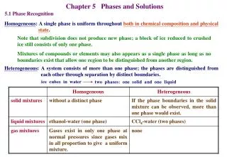
Download
1 / 22
220 likes | 372 Views
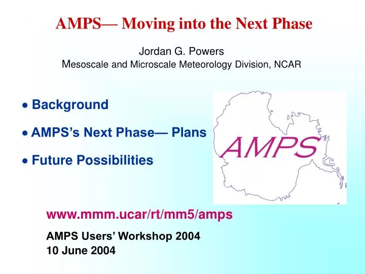
AMPS — Moving into the Next Phase. Jordan G. Powers M esoscale and Microscale Meteorology Division, NCAR. Background AMPS’s Next Phase — Plans Future Possibilities. www.mmm.ucar/rt/mm5/amps AMPS Users’ Workshop 2004 10 June 2004. I. Background.

E N D
AMPS— Moving into the Next Phase Jordan G. PowersMesoscale and Microscale Meteorology Division, NCAR Background • AMPS’s Next Phase— Plans Future Possibilities www.mmm.ucar/rt/mm5/amps AMPS Users’ Workshop 2004 10 June 2004
I. Background • Antarctic Mesoscale Prediction System (AMPS)At-a-glance • NCAR & Polar Met. Group, BPRC, The Ohio State Univ. • Plus: SPAWAR contributions • Real-time, high-resolution mesoscale model over Antarctica (since 2000): “Polar MM5” Support of Antarctic forecasting and science operations Tailored to needs of (1) SPAWAR forecasters and the USAP (2) international community
Phase 2 Goals • October 2002–September 2004 (current phase) • New Data Assimilation Capability: 3DVAR • – 3-Dimensional Variational data assimilation • Polar Physics Development • Ex: Upper boundary condition • Verification • – Seasonal forecast verification • – SOM (Self-Organizing Map) study • AMPS Users’ Workshops
Phase 2: Additional Gains • 10-km Antarctic Peninsula grid • Expansion in international support • Scientific field activity support • GLOBEC (Global Ocean Ecosystem Dynamics) • NASA P3 Pine Island Bay operations (flights investigating calving glaciers) • Archive-derived climatologies for Raytheon support • Rescues: Flight Assistance September 2003 (South Pole medevac) April 2004 (McMurdo medevac)
II. AMPS’s Next Phase— Plans Next Phase: October 2004–September 2006 Implementation of the Weather Research and Forecasting Model (WRF) Enhanced Grids Ex: 30 km Antarctica grid 20 km grid NB: Dependent on computing hardware Data assimilation – Explore new approaches: Ensemble Kalman Filter – New data sources E.g: COSMIC GPS radio occultations (2006)
New Physics – Blowing snow parameterization – Cloud-radiation interaction: representation of downwelling longwave radiation – Treatment of horizontal pressure-gradient force Verification – Evaluation of new physics – Analysis of event performance Climatological Database – Web-based tool to allow compilation of climatology of locations, using archive
Assistance to International Antarctic Activities • Italy (PRNA) Terra Nova Bay British Antarctic Survey Rothera Germany Neumayer Australia . Casey, Davis, Mawson (Bureau of Met.) South African (S.A. Weather Service) Russia Novolazarevskaya Japan Syowa Chile Eduardo Frei Norway Troll
The Weather Research and Forecasting (WRF) Model • Designed for both research and operational applications • Extensive use for real-time forecasting • Registered users as of June 1, 2004: 845 • WRF Partner/Collaborators • NCAR • NOAA National Centers for Environmental Prediction • NOAA Forecast Systems Laboratory • Air Force Weather Agency (AFWA) • Federal Aviation Administration • Naval Research Laboratory 36h WRF Precip Forecast 10 km WRF Analyzed Precip 27 Sept. 2002 Hurricane Isidore
WRF Frontal Forecast 24-hr WRF fcst: Valid 00 UTC 25 October 2001 (12-km grid) WRF vertically-integrated cloud water IR imagery
WRF AMPS Test Forecast 72-hr WRF fcst: Valid 12 UTC 17 Nov 2003 (30-km grid) MM5 WRF SLP interval= 4 mb SLP interval= 4 mb
III. Future Possibilities • Application of New Verification/Analysis Techniques Field Campaign Support • Enhanced International Collaborations and SPAWAR Involvement Eduardo Frei Stn.
Applications of Kinetic Energy Spectra from AMPS Real-Time Verification System Power spectra of wind and computed from aircraft data (Nastrom and Gage 1985) k-3 and k-5/3power curves shown GASP data (Global Atmospheric Sampling Program)
AMPS Kinetic Energy Spectra • Spectra computed from u, v, w through ~525–237 mb layer Hr. 24 Fcst init: 1200 UTC 3 Sept 2003 Grid x indicated
100 Spectra for 10-km and 3.3-km AMPS grids Hr. 24 Fcst init:00 UTC 03 Sept 2003
Height (m) Interval=10 m Wind speed (m/s) Interval= 2.5 m/s 400 hPa height and wind speed on 10-km AMPS grid Hr. 24 Fcst init:00 UTC 03 Sept 2003
10-km AMPS Spectra (Hr 24) Area / subarea of domain indicated – Spectral analysis may illuminate effects of high-resolution grids traditional error statistics might not reveal – Application of high-res grids over Antarctica may improve representation of the variance of tropospheric flows (i) Better reproduction of observed power laws on the mesoscale (ii) Greater power variance on the mesoscale
Field Campaign Support • 1) Antarctic RIME: Antarctic Regional Interactions Meteorology Experiment (A-RIME) Field phases: Dec. ’06– Jan. ’07 Dec. ’07– Feb. ’08 Sept. ’08–Feb. ’09 Planned measurement sites for RIME instrumentation deployments. A few existing AWSs shown as small green circles. (Many AWSs not shown.)
– Pre- A-RIME Studies Analysis of AMPS archive for instrument siting and information for logistical issues Case studies to identify meteorology issues for exploration in A-RIME – A-RIME Logistics Special AMPS products and windows Ex: Ferrell close-up coverage, time series & soundings for A-RIME points Higher-resolution experimental grid(s) Ex: 1-km one-way nests (e.g., Ross Air Stream)
Field Campaign Support (cont’d) 2) ANTCI: Antarctic Tropospheric Chemistry Experiment First field phase: Nov.–Dec. 2005 Twin Otter flights to sample PBL – AMPS Support Flight forecasting and specialized products Model datasets for event analysis
ANTCI Flights: Yellow areas: focused on sulfur species; Green areas: focused on reactive nitrogen compounds; Blue areas: focused on both.
Future Possibilities (cont’d) • Enhanced International Cooperation and Support • – Contributions to/collaborations in AMPS operations • – Involvement of COMNAP in support of AMPS (?) • (Council of Managers of National Antarctic Programs) • SPAWAR Involvement • – Participation in AMPS operations during field seasons • – Establishment of AMPS liaison • Ex: Product coordinator
Summary • AMPS next phase (2004–2006) planning in progress • Implementation of new model for AMPS: WRF • Improved system capabilities • – Polar physics development • – Data assimilation improvement • Strengthen Antarctic observational–forecasting–modeling operational & research collaborations, including international efforts