FGCS Fixed Reference Station Workgroup Meeting - NOAA Campus, Silver Spring, MD (July 15, 2008)
The FGCS Fixed Reference Station Workgroup convened on July 15, 2008, at the NOAA Campus in Silver Spring, MD, to discuss key activities and advancements in real-time GNSS positioning. Led by Senior Geodesist Bill Henning, the meeting addressed ongoing projects at the National Geodetic Survey (NGS), including the operation of NTRIP casters, development of best practice guidelines, and participation in industry forums. Attendees explored the needs of the FGCS and the impacts of various geospatial phenomena on accurate positioning, paving the way for enhanced GNSS services.
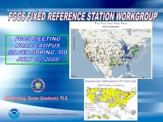

FGCS Fixed Reference Station Workgroup Meeting - NOAA Campus, Silver Spring, MD (July 15, 2008)
E N D
Presentation Transcript
FGCS FIXED REFERENCE STATION WORKGROUP FGCS MEETING NOAA CAMPUS SILVER SPRING, MD JULY 15, 2008 Bill Henning, Senior Geodesist, PLS.
FGCS-FIXED REFERENCE STATION WORKGROUP • ACTIVITIES AT THE NGS • WHAT ARE THE ACTIVITIES OF OTHER AGENCIES? • WHAT ARE THE NEEDS OF THE FGCS?
REAL-TIME ACTIVITIES AT THE NGS • OPERATE AN NTRIP CASTER (Fed. Owned/operated – currently 6, soon 9) • DEVELOP AND PUBLISH GUIDELINES DESCRIBING BEST PRACTICES.(RTK Users draft, RTN Operators draft, etc.) • PARTICIPATE IN MEETINGS, FORUMS, WORKSHOPS, ETC., CONCERNING REAL-TIME NETWORKS. SEEK LEADERSHIP ROLES.(FIG, ESRI, ACSM, RTCM, etc.) • RESEARCH PHENOMENA AFFECTING ACCURATE REAL-TIME POSITIONING. (HTDP, IDOP, GEOID08, etc.)
POSITIONING GPS/GNSS POSITIONING PASSIVE MONUMENTSACTIVE STATIONS STATIC NGS 58/59 GUIDELINES RTN FGCS ACCURACY STDS. VRS MAC FKP MFTRS. SOFTWARE & DOCS.½ COST ORDOUBLE WORK DONE OPERATORS DRAFTGUIDELINES ≈ 75 IN USA, 200+ WORLDWIDE REAL-TIME SINGLE BASE MONUMENTS CLOSEST BASE CORS NGS CLASSICAL USER GUIDELINES-DRAFT
I. NGS Real Time Stream Team Product Manager Richard Snay Outreach and User Relations Bill Henning Pam Fromhertz CORS Data Streams Charlie Schwarz Neil Weston Giovanni Sella IT Team Bruce Sailer Hong Chen Sky Chaleff
Supporting New Products Real time - essential that CORS/NGS supports this activity. TO DO: compute ultra-rapid orbits, QC coordinates, provide data-streams. Currently CORS only supports 6 sites with limited data-streams GNSS: add GLONASS and new GPS frequencies to online storage in 2008 OPUS-flavors NOAA-sister products Space Weather Prediction Center went operational in 2007 GPS Met Program will go operational in 2010 Co-Ops coordinates for NWLON 1200 + 400 TO BE ADDED IN 2008 GNSS sites
NGS HEADQUARTERS HNPT MDSI NGS TESTING SITES – CORS STATIONS HNPT, MDSI, VAGP, PRMI VAGP
NGS TESTING SITES –PRMI, VITH, VIKH VITH PRMI VIKH
NGS TESTING SITES –BARH ON LINE SOON COLLEGE OF THE ATLANTIC GIS LABORATORY BARH
WELCOME & LINKS PAGE http://www.ngs.noaa.gov/CORS-Proxy/NGSRealtimeGNSS/welcomeNGSNtrip.jsp
REGISTRATION PAGE ngs.realtime.gnss@noaa.gov
- GUIDELINES, SPECS, STANDARDS√ SINGLE-BASE USER – DRAFT OUT RTN PLANNING & NETWORK DESIGN RTN CONSTRUCTION/SITE EVALUATION RTN ADMINISTRATIVE RTN USER II. RT POSITIONING GUIDELINES RTN TEAM – ADVISORS AND PARTNERS
http://www.ngs.noaa.gov/ • WHY SINGLE-BASE? • ACCOMMODATE LEGACY USERS • CLOSEST BASE NETWORKS • AREAS WITH NO CELL COVERAGE • PROJECT SITE APPLICATIONS, SUCH AS MACHINE CONTROL • WHY EMPIRICAL? • PLETHORA OF VARIABLES • TIMELINESS • PORT TO RTN USERS • DYNAMIC NATURE OF RT POSITIONING
SOME RT FIELD CONSIDERATIONS - Multipath - Position Dilution of Precision (PDOP) - Baseline Root Mean Square (RMS) - Number of satellites - Elevation mask (or cut-off angle) - Base accuracy- datum level, local level - Base security - Redundancy, redundancy, redundancy - Part(s) Per Million Error (ppm) – iono, tropo models, orbit errors - Space weather- sunspot numbers, solar maximum - Geoid quality - Site calibrations (a.k.a. Localizations) - Bubble adjustment - Latency, update rate - Fixed and float solutions - Accuracy versus Precision - Signal to Noise Ratio (S/N or C/N0) - Float and Fixed Solutions - Carrier phase - Code phase - VHF/UHF radio communication - CDMA/SIM/Cellular TCP/IP communication - WGS 84 versus NAD 83, or other local datumslocal and national datums - GPS, GLONASS, Galileo, Compass Constellations
EXAMPLES OF RTN ADMINISTRATORS IN THE USA • ACADEMIC/SCIENTIFIC • SPATIAL REFERENCE CENTERS • VARIOUS DOTS • COUNTY • CITY • GEODETIC SURVEYS (NC, SC) • MANUFACTURERS • VENDOR NETWORKS • AGRICULTURE • MA & PA NETWORKS RAPIDLY GROWING
REAL TIME NETWORKS (RTN) • HOW ARE THEY ESTABLISHED? • HOW ARE THEIR COORDINATES COMPUTED? ARE THEY CONSISTENT? • HOW IS THE NETWORK ADJUSTED? • HOW DOES THE RTN ALIGN TO THE NSRS? • CAN USERS USE ANY MANUFACTURERS’ EQUIPMENT IN THE RTN? • DO OVERLAPPING NETWORKS GIVE THE SAME COORDINATES? • WHAT ARE THE FIELD ACCURACIES? ?
II. RTN GUIDELINES IN NGS POLICY STATEMENT 3. Develop standards, specifications, and guidelines for administrating RTN. This may include: a. Reference station siting and construction considerations. b. Policy to promote the use of open source, generic data formats such as RTCM via the use of the most current Networked Transport of RTCM via Internet Protocol (NTRIP) programs. d. Policy to encourage the RTN to support as many different GNSS hardware and firmware packages as possible. e. Guidelines to recommend methods to enable RTN results to be aligned with the NSRS. This may include methods to archive and quality check RTN data. f. Guidelines to recommend methods to determine accurate positional coordinates and velocities for RTN reference stations. ftp://ftp.ngs.noaa.gov/dist/whenning/RTNteam/REVIEW/ RTpolicy.June2008.doc
OPERATING A RTN- CHAPTER ONE DRAFT ftp://ftp.ngs.noaa.gov/dist/whenning/RTNteam/REVIEW/ RTNguidelines.June08.doc • #1 Include a subnetwork of the RTN into the National CORS network. This would be three stations If RTN has less than 30 stations, 10% of RTN with greater than 30 stations. #2 Align all RTN reference stations coordinates to the CORS network at 2-cm horizontal and 4-cm vertical #3 For each reference station in the RTN, use the Online Positioning User Service (OPUS) at http://www.ngs.noaa.gov/OPUS/ to test for the continued consistency of its adopted positional coordinatesand velocity on a daily basis, and revise the station’s adopted coordinates and/or velocity if the tests reveal a need to do so.
BAKERSFIELD2 CORS- SEASONAL N/S & VERTICAL MOVEMENT 2002 2003 2004 2005 2006 2007 2008 2002 2003 2004 2005 2006 2007 2008 • 2003 2004 2005 2006 2007 2008
EXAMPLE OF WHY RTN REFERENCE STATIONS SHOULD BE MONITORED SUBSIDENCE ≈ 6 MM / YEAR ENGLISH TURN CORS
III. IDOP WITH SCALE COULD CORRELATE TO ACCURACY
IDOP VALUES – 4 CORS EXAMPLE BEST IDOP = 1 √ N THEREFORE, WITH 9 CORS, THE IDOP AT THE CENTROID WOULD BE .33, WITH 4 CORS IT WOULD BE .5 AT THE CENTROID ADDITION OF RMS OF DISTANCE TO CORS CONTRIBUTING TO THE SOLUTION GIVES FINAL UNITLESS NUMBER .87 .87 “IDOP” WILL BE THE SUBJECT OF A FORTHCOMING PAPER BY DRS. RICHARD SNAY, TOM SOLER AND CHARLES SCHWARZ .7 .6 .8 .5 .6 .7 .8 .87 .87
OPUS-RS Accuracy for 15-minute data sets
ACTIVITIES IN OTHER AGENCIES?WHAT GUIDANCE OR PRODUCTS ARE NEEDED? WORKGROUP ISSUES ftp://ftp.ngs.noaa.gov/dist/whenning/FGCS