Download
1 / 32
320 likes | 483 Views
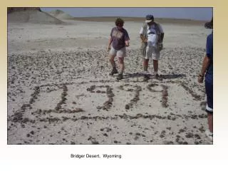
Bridger Desert, Wyoming. review. Wind can cause erosion, however, it is not as powerful as glaciers and streams. Geologists use a special word called “ eolian ” to describe geological processes associated with wind erosion. (The word eolian comes from Aeolus, who was the Greek god of winds).

E N D
review Wind can cause erosion, however, it is not as powerful as glaciers and streams. Geologists use a special word called “eolian” to describe geological processes associated with wind erosion. (The word eolian comes from Aeolus, who was the Greek god of winds) Alistair J.Malcolm
review Wind belts on the Earth Over small spatial and temporal scales, wind directions can be rather random, however, winds follow certain global patterns over the long term.
review Wind belts on the Earth The Earth’s wind belts can be understood by the following principles: 1. The earth gets more solar energy at lower latitudes (e.g. the equator) than at higher latitudes (e.g. the poles). This is because the sun’s rays are more direct at lower latitudes. The same amount of solar energy is spread out along a larger surface at higher latitudes than at lower latitudes.
review Wind belts on the Earth 2. Warm air rises, and cool air sinks. 3. The Coriolis effect causes the large-scale motion of fluids to curve to the right (clockwise) in the northern hemisphere and to the left in the southern hemisphere (counter-clockwise). The Coriolis effect is related to the physics of motion along the surface of a rotating body
review Wind belts on the Earth There are multiple convection belts of air. Within each convection belt, the air near the surface is moving in the opposite direction as the air moving at the top of the atmosphere.
review Wind belts on the Earth For example, in this convection belt, air near the surface is moving toward the north and air high in the atmosphere is moving toward the south.
review Wind belts on the Earth The different convection belts occur within the following latitudes: Equator to 30o 30o to 60o 60o to the poles So, there are 6 convection belts total.
review Wind belts on the Earth Before we get started talking about each of these belts, we should be clear on some terminology: If you add the suffix -ly to a direction, it means the wind is coming FROM that direction. For example, if I say that the wind is northeasterly, this means that the wind is coming from the northeast and is moving toward to southwest. Also, we need to be clear whether we are talking about the air moving near the surface or the air at the top of the atmosphere. Remember that they flow in opposite directions.
review Wind belts on the Earth Between the equator and 30o. These are called the Trade Winds. Air that is near the surface is moving toward the equator. The Coriolis effect causes this air to move in a clockwise direction in the northern hemisphere and a counter-clockwise direction in the southern hemisphere. In both hemispheres, this causes the air to move from the east to the west (in other words, the wind is easterly). As a result: In the northern hemisphere, wind near the surface is northeasterly. In the southern hemisphere, wind near the surface is southeasterly.
review Wind belts on the Earth Between the 30o and 60o. These are called the Westerlies. Air that is near the surface is moving toward the poles. The Coriolis effect causes this air to move in a clockwise direction in the northern hemisphere and a counter-clockwise direction in the southern hemisphere. In both hemispheres, this causes the air to move from the west to the east (in other words, the wind is westerly). As a result: In the northern hemisphere, wind near the surface is South-Westerly. In the southern hemisphere, wind near the surface is North-Westerly.
Wind belts on the Earth • The Earth’s wind belts play a large role in the geographic distribution of climate. • At the equator: • As warm air rises, it cools. • As air cools, it can hold less water, so water precipitates (forms clouds and/or rain) • This is why the tropics are cloudy and has abundant precipitation (this provides a good environment for jungles). Near 30o latitude: • Dry air sinks (this is the air that lost its water at the equator). • The constant downwelling of dry air produces an arid climate (deserts) In temperate regions (between 30o and 60o) • The climate is largely effected by the interplay of cool air flowing from the poles and the warm air flowing toward the poles. • Where cool and warm areas meet is called a front (storms often occur there)
Deserts often occur near 30o latitude, where dry air is sinking
Where do deserts occur • Near 30o N and 30o S latitude where dry air sinks. • In “rainshadows” – regions behind mountains. As air moves over a mountain, the air cools and water precipitates. The air that makes it over the mountain and to the other side is very dry, forming an arid environment. • 3. On large continents (such as Asia). As air moves over a continent, precipitation (rain) causes the air to become drier. Eventually, the air will lose all of its moisture, forming an arid environment. • An example is the Gobi desert in Asia. • 4. Cold, polar regions. Where air is very cold, it cannot hold moisture, forming an arid environment.
Wind can carry sediments • The amount of sediment that wind can carry depends on: • The strength of the wind • faster winds can carry more sediments • The size of the sediments • Even light breezes can carry dust (the smallest eolian sediments) • Moderate breezes can slide or roll sand grains along the ground • Only very strong breezes can carry sand grains • The nature of the sediments • Wind can only lift sediments which are unconsolidated (loose) and dry. Wet sediments are too cohesive (stuck together).
Wind as a transport agent • Eolian processes dominate in regions where the sediments are unconsolidated and dry. • Deserts • Beaches • Even though beaches are near the water, the sun will often dry the sand. • Near glaciers • Glaciers produce very fine sediments called rock flour which is easily carried by the wind.
Eolian Sediments • Dust is fine-grained sediment composed of • Microscopic rock and mineral fragments • Clays • Pollen and bacteria • Charcoal (due to fires) • Particles released from the burning of coal • Synthetic chemicals Sand – larger sediments – mainly quartz but can be calcite or gypsum in some regions. Dust can be carried for thousands of miles, but sand is usually not carried more than a couple hundred miles.
Desert Erosion Sand carried in the wind can abrade rocks like a sand blaster. Ventifact: A rock that has been sand-blasted, having curved or flat surfaces that meet at sharp ridges.
Desert Erosion Deflation: When wind blows away sediments from a region (such as a dried-up lake bed or flood plain), leaving behind a depression.
Desert Erosion Desert Pavement: a layer of gravel left behind after the wind has blown away the smaller sediments. (The dust and sand has been blown away – only the larger sediments are left)
Dunes and ripples form in regions with • Strong winds (strong enough to move sand grains) • Lots of sand (beaches and regions with eroding sand stones)
Loess (pronounced “luss”): layers of sediment that are formed when wind-blown dust is deposited. As wind speed is reduced, the amount of dust it can carry is reduced, so the dust particles are deposited as layers of loess. Loess provides very fertile soil for farming, but it erodes very easily. During the Ice Ages, the glaciers made a tremendous amount of rock flour which was blown for thousands of miles and later deposited as loess. Loess in the Catalina mountains in Arizona
Energy • Reserves: Energy deposits that have been: • (note: deposits refer to any energy source – oil, gas, uranium, etc.) • Already discovered • Can be mined both economically and legally • Resources: All energy deposits on the Earth. Reserves include: • Reserves • Unprofitable deposits • Undiscovered deposits • The amount of energy in reserves can be calculated, but we can only make educated guesses regarding how much energy is in resources
Energy resources can be put into 2 categories: • Renewable: resources that are essentially limitless such • Solar • Geothermal • Biofuels (such as ethanol) • Hydropower (dams) • Non-Renewable: resources that are created much more slowly than consumption such as • Oil • Gas • Coal Currently, worldwide energy consumption comes mainly from non-renewable energy resources (90%).
Energy sources come in a variety of forms (barrels of oil, tons of coal, etc.) Quad: a unit of energy used to compare different types of energy sources The quad is based on the BTU (British thermal unit). 1 BTU is the energy needed to increase the temperature of 1 pound of water by 1o Fahrenheit. 1 quad = 1015 BTUs (1,000,000,000,000,000 BTUs) The United States uses about 100 quads of energy per year. World consumption of energy is about 400 quads The United States uses a fourth of the world’s energy consumption
Estimate of the Earth’s non-renewable energy resources (not reserves) (360,000 quads total) Enough for 900 years? Most of our non-renewable energy resources are in the form of uranium!