Download
1 / 34
360 likes | 568 Views
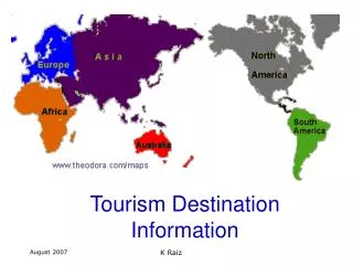
Tourism Destination Information. Introduction. A person working in the Tourism Industry needs to understand: General World Geography The Continents The Oceans Major Physical Features Time Zones Climate Information Sources. Land Area 148,940,000 sq km 29 % Water Area

E N D
Introduction • A person working in the Tourism Industry needs to understand: • General World Geography • The Continents • The Oceans • Major Physical Features • Time Zones • Climate • Information Sources Land Area 148,940,000 sq km 29 % Water Area 361,132,000 sq km 70.8 % Fresh Water Area – less than 2 % World Population 6,633,190,000 20 July 2006 K Raiz
The Continents #1 Asia 44,579,000 sq km #2 Africa 30,065,000 sq km #3 North America 24,256,000 sq km #4 South America 17,819,000 sq km #5 Antarctica 13,209,000 sq km #6 Europe 9,938,000 sq km #7 Australia / Oceania 7,687,000 sq km K Raiz
Africa & Australia Africa Australia K Raiz
Asia & Europe Asia Ural Mountains Aral River Caspian Sea Caucasus Mountains Black Sea & Bosphorus Strait For Homework located these features on your Map of Europe K Raiz
North & South America North America South America K Raiz
The Oceans K Raiz
Pacific Ocean North Pacific Pacific South K Raiz
Indian Ocean K Raiz
Atlantic Ocean K Raiz
Arctic Ocean Southern Ocean K Raiz
Latitude & Longitude K Raiz
Equator K Raiz
Prime Meridian & Tropics Prime Meridian K Raiz
Arctic Circle 66ºN 66ºS Antarctic Circle K Raiz
International Date Line 180º line of longitude middle of the Pacific Ocean imaginary line - separates 2 consecutive calendar days. not perfectly straight line In the Eastern Hemisphere, left of the International Date Line (the date) is always one day ahead of the date (or day) in the Western Hemisphere. note that Tonga and Samoa have the same time but are (1) day apart, as Samoa is in the Western Hemisphere, on the opposite side of the International Dateline from Tonga. Fiji is (1) hour earlier than Tonga. Hawaii, further to the east of Samoa, is (1) hour later in time. K Raiz
Hemispheres K Raiz
Climate Types Equatorial Tropical Sub - Tropical Temperate Continental K Raiz
Climate Types • hot all year • a very low temperature range - usually less than 3ºC • wet climate annual rainfall often more than 2000 mm • Lies close to the equator • Eg Singapore 1ºN Equatorial Tropical Sub - Tropical Temperate Continental K Raiz
Climate Types • hot all year 28 - 32 ºC • Wet & Dry Seasons • Seasonal change of wind direction - called monsoon • Lies between Tropic of Cancer [N] & Tropic of Capricorn [S] • Eg Fiji Equatorial Tropical Sub - Tropical Temperate Continental K Raiz
Climate Types • 3 Seasons Summer, Spring, Autumn • Lies between Tropic of Cancer & 33º[N] & Tropic of Capricorn & 34 º[S] • Eg Newcastle Equatorial Tropical Sub - Tropical Temperate Continental K Raiz
Climate Types • 4 Seasons Summer, Spring, Autumn, Winter • Lies between 33 - 66ºN & 33/4 - 66ºS • Eg Melbourne Equatorial Tropical Sub - Tropical Temperate Continental K Raiz
Climate Types • extreme difference between day & night time temperatures • away from moderating effects of the sea Equatorial Tropical Sub - Tropical Temperate Continental K Raiz
Factors that influence Climate Altitude Seasons Latitude Coast vs Inland Prevailing Wind Direction Proximity to Hills & Mountains K Raiz
Altitude Altitude measures height above sea level measured in metres as Height increases temperature decreases K Raiz
Latitude Latitude measures the distance from the equator in degrees north or south eg Singapore 1ºN As Latitude Increases temperature decreases K Raiz
Seasonality Seasons tell us about the normal weather patterns and temperature ranges Eg Summer Autumn Winter Spring K Raiz
Coastal vs Inland Due to the moderating effects of the Sea Coastal regions have less extremes of temperature ie the water cools and heats slowly & away from large bodies of water the land heats & cools rapidly K Raiz
Other Factors Prevailing Wind Direction the West of a Continent tends to be drier than the East Proximity to Hills & Mountains due to local prevailing wind direction one side of the mountains tends to be wetter than the other K Raiz
Politics is a form of social organisation K Raiz
Travel Documentation Passports Health Documents[sometimes] Visas Information Sources for Travel Issues www.s m a r tt r a v e l l e r.gov.au K Raiz
Gross Domestic Product GDP • Value of all Goods & Services • Produced & Sold in that country in one Year • Measured in USD K Raiz
Tourism Generating Regions Tend to be Developed or Developing Nations Tourism Destination Regions Can be any Developed, Developing or Lesser Developed Nations K Raiz