Teaching the Geological Subsurface using 3D Models
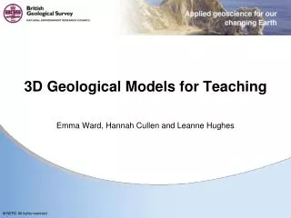
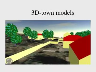
Step 2: Draw Cross-sections. Step 3: Fence diagram. Teaching the Geological Subsurface using 3D Models Steve Thorpe ( sthorpe@bgs.ac.uk ) & Emma Ward ( eward@bgs.ac.uk ) from the British Geological Survey. +.

Teaching the Geological Subsurface using 3D Models
E N D
Presentation Transcript
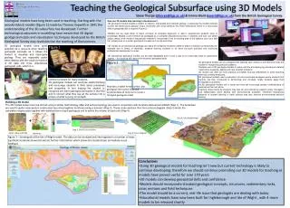
Step 2: Draw Cross-sections Step 3: Fence diagram Teaching the Geological Subsurface using 3D Models Steve Thorpe (sthorpe@bgs.ac.uk) & Emma Ward (eward@bgs.ac.uk) from the British Geological Survey + Geological models have long been used in teaching. Starting with the wooden block models (figure 1) made by Thomas Sopwith in 1841 the understanding of the 3D subsurface has developed. Further technological advances in modelling have meant that 3D digital geological models and visualisation techniques developed by the British Geological Survey may revolutionise the teaching of Geosciences. How can 3D models help learning in Geosciences? • 3D geological models enable a student to observe, manipulate and interpret geology; in particular the models instantly convert two-dimensional geology (maps, boreholes and cross-sections) into three dimensions which is a notoriously difficult geospatial skill to acquire (Figure 2) • Models can be used either to teach concepts to complete beginners or add to experienced students body of knowledge. Models could therefore be packaged as a complete educational journey or students and tutor can select certain areas of the model or educational material to incorporate it into an existing area of the syllabus such as a field trip, project work or a certain geological concept such as dip and strike • 3D models as an educational package can easily be utilised by students unable to attend university conventionally (for example due to illness or disability), distance learning students or for extra curricular activities and continuing professional development courses • 3D educational geological models can be used repeatedly and in such a way as to continually build on geoscience aspects – this practice will improve the student’s geospatial skills. Step 1: Map and DTM Boreholes 3D geological models have great potential as a resource when teaching geological concepts as it allows the student to visualise and interrogate geology. They are especially useful when dealing with the visual conversion of 2D data into three dimensional geological units, which is a Figure 1 Figure 2 • 3D geological models can be compared with features seen directly in the field which aids the student in recognising particular patterns. • Students use of 3D geological models is active and the accompanying educational material needs to be engaging, dealing with real scientific problems • 3D models can often be more practical and better financial alternatives to some teaching methods currently employed. • 3D geological models used in education should incorporate strategies where students first explore, are then introduced to terminology and concepts, finally students apply their knowledge to problems. • As 3D geological models are a visual tool they will encourage greater understanding of geoscience than text alone. • Learning issues faced by students may also be encountered by experts, policy managers, and stakeholders when dealing with environmental problems. Therefore educational research of student learning in earth science may also improve environmental decision making. common problem for many students. 3D geological models can reinforce spatial thinking and encourage students to think about processes and properties, in turn helping the student to recognise pre-learnt geological principles in the field and to convert what they see at the surface into a picture of what is going on at depth. Map data, a digital terrain surface, plus geological information (map and borehole data) all comprise to create a 3D digital geological model Building a 3D model The 3D models shown here are all built using a similar methodology. Map and surface topology are used in conjunction with borehole data stored at BGS (Step 1). The boreholes are used to guide cross-section construction by joining together boreholes along a transect (Step 2). These cross-sections then form a fence diagram (Step 3) which the calculation engine uses together with distributions for each geological unit to define the volume of each unit (Step 4). Step 4: Calculated Model Figure 3 – Screengrab of the Isle of Wight model. The data can be analysed and interrogated in a number of ways (synthetic borehole shown) to extract further information which allows the student/user immediate visual feedback • Conclusions • Using 3D geological models for teaching isn’t new but current technology is likely to continue developing; therefore we should continue promoting our 3D models for teaching as models have proved useful for over 170 years • 3D models can develop geospatial skills and confidence • Models should incorporate standard geological concepts, structures, sedimentary rocks, cross sections and field techniques • The model should be a current, real-life issue that geologists are dealing with today. • Educational models have now been built for Ingleborough and Isle of Wight , with 4 more models to be released shortly