Download
1 / 63
630 likes | 719 Views
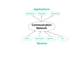
HydroNetwork Applications. This lecture continues on from the slides we began on the last class In this class, we talk about how to create HydroNetworks , Linear referencing on networks NHDPlus in the United States AWRIS project in Australia There are no new additional readings.

E N D
HydroNetwork Applications • This lecture continues on from the slides we began on the last class • In this class, we talk about • how to create HydroNetworks, • Linear referencing on networks • NHDPlus in the United States • AWRIS project in Australia • There are no new additional readings
Summary Concepts from Last Lecture • Four key constructs • Cell to cell water movement on DEMs • Line to Line water movement on networks • Area flows to line (connect land and water systems – Reach Catchments) • Area flows to point on line (Watershed delineation from designated points)
Summary Concepts (2) • A network is a connected set of points (junctions) and lines (edges) that supports tracing functions • Three data model components • Geographic (x,y,z) • Logical (point-line topology connections) • Addressing (position m along the line)
Hydrologic Networks • Hydrologic data includes: • Single-line streams • Double-line streams • Braided streams • Manmade channel systems • Waterbodies
Flow Line Traces movement of water in a one-dimensional flow system
Introduction to the Hydro Network • Hydro Edge – think of Arc • HydroJunction – think of Node • Waterbody – think of Polygon
Edge Junction Flow Network A connected set of flow edges
Network Building • Define flow-paths within double-line streams and waterbodies. • Define network sinks and sources.
Network Connectivity Find connected Find loops
Network Flow Direction • Enable flow in flow-paths. • Disable flow in shorelines Sink Flow direction is unknown
Network Flow Direction • Enable flow in flow-paths. • Disable flow in shorelines Sink Flow direction is known
Network Tracing Trace Upstream Trace Downstream
Trace Path Find the shortest path between two points on the network
Linear Referencing Where are we on a line?
Proportional Aliasing Distance is measured Relative to the length of the line as a percentage 0% – 100%
Setting Percent Measure pMSeg.SetAndInterpolate MsBetween 0, 100 pMSeg.SetAndInterpolate MsBetween 100, 0 0 – 100 going downstream 0 – 100 going upstream
Some terminology • Hydrography – the mapping of water features • Blue line features on topographic maps (streams, rivers, lakes,…) • More generally, hydrography also includes the mapping of bathymetry and extent of estuaries and coastal waters • National Hydrography Dataset (NHD) – a data model for storing topographic map hydrography • Medium resolution (1:100K) is complete for US • High resolution (1:24K) is complete for most of the US • NHDPlus – a new data model integrating 1:100K resolution NHD with catchments and derived attributes from the National Elevation Dataset
National Hydrography Dataset Key feature classes Five feature classes with NHDFLowline built into A geometric network NHDPoint, NHDLine, NHDArea are point, line and area water features on map apart from flowlines and waterbodies
NHDPlus Reach Catchments ~ 3km2 Average reach length = 2km 2.3 million reaches for continental US About 1000 reach catchments in each 8-digit HUC
Slope Elevation Mean annual flow Corresponding velocity Drainage area % of upstream drainage area in different land uses Stream order Reach Attributes
Delivering on National Water Information Needs David R. Maidment Director, Center for Research in Water Resources University of Texas at Austin WIRADA Science Symposium Melbourne, Australia 4 August 2011
Our Journey Begins…..Melbourne Cup Day, November 2006 • I was in Canberra doing a seminar jointly with Rob Vertessy about geospatial data for water • The Prime Minister met on this day in Canberra with the Premiers of all the States to confront the drought • The country was in crisis • The drought was already severe and its ultimate magnitude and duration were unknown Action was needed!!!
What was the state of water knowledge in Australia at that time? • Science – Rich – a real legacy of historical investment in CSIRO, ANU and elsewhere • Modeling – Rich – CRC’s for Catchment Hydrology and eWater, and elsewhere • Information – Limited • 250m DEM • No consistent digital blue line stream hydrography (ouch!!) • 37 separate stream gaging networks AWRIS and WIRADA were prompted by these and other deficiencies in information
River Gage Networks 9079 gages in 37 networks Average = 245 gages/network
Some months pass…. then comes (Jan 2007) http://www.nalwt.gov.au/files/national_plan_for_water_security.pdf
Australian Water Resources Information System (AWRIS) Slide: Rob Vertessy
Components of AWRIS Slide: Rob Vertessy, BoM
WIRADA (2008-2013)Water Information Research and Development Alliance CSIRO research program to support the AWRIS development being done by the Bureau of Meteorology Slide: Rob Vertessy, BoM
Three years in …..What is the state of Water Information now? • Progress has been made in each of these four components • They are very different to one another • The challenge now is how to link them
Australian National Climate Database • This is a core competency of the BoM • Augment with evaporation derived from remote sensing StdDev of 8 methods of estimating evaporation Image: Albert van Dijk, CSIRO
Lake Argyll – Remote Sensing as Time Series! Slide: Philippa Berry, DeMontfort University • Lake timeseries plus statistics and curve-fiting analysis.
Australian Hydrological Geospatial Fabric • Four key constructs • Cell to cell water movement on DEMs • Line to Line water movement on networks • Area flows to line (connect land and water systems – Reach Catchments) • Area flows to point on line (Contracted Nodes and Catchments)
United States Experience with DEM Improvement 1990’s 5% Error in delineated watershed area 0.5% 2000’s 1 arcsec: 30 m 3 arcsec: 90 m DEM Cell Size
National Elevation Dataset for Australia Existing New 1 Arc Second – 30 m 9 Arc Second – 250 m 1 cell 81 cells Two orders of magnitude improvement! Wow! Images: John Gallant, CSIRO
National River Network for Australia • Geometric Network • Geometry model: Where am I? (x,y coordinates) • Logical model: Who am I connected to? (topology) • Addressing model: Where are things on me? (linear referencing) Line flows to Line Image: Elizabeth McDonald, BoM