Download
1 / 11
110 likes | 227 Views
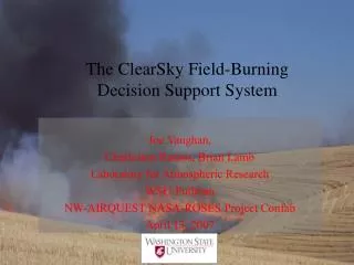
The ClearSky Field-Burning Decision Support System. Joe Vaughan, Charleston Ramos, Brian Lamb Laboratory for Atmospheric Research WSU-Pullman NW-AIRQUEST NASA-ROSES Project Confab April 13, 2007. Outline. ClearWhat? Original and current system Ensemble Experiment Current Directions

E N D
The ClearSky Field-Burning Decision Support System Joe Vaughan, Charleston Ramos, Brian Lamb Laboratory for Atmospheric Research WSU-Pullman NW-AIRQUEST NASA-ROSES Project Confab April 13, 2007
Outline • ClearWhat? • Original and current system • Ensemble Experiment • Current Directions • ClearSky and NASA-ROSES project
Initial ClearSky Evaluation • Rahul Jain’s Findings: • ClearSky is highly sensitive to Wind Speed & Wind Direction • Small differences in Wind Direction determine whether or not smoke plumes are predicted to affect an air quality monitoring station • Recognized a need to represent the uncertainty of the meteorological conditions… Thus arose the idea of using Ensemble Meteorology!
Ensemble ClearSky Implementation IC/BC landuse terrain University of Washington Mesoscale Ensemble System Web-served PM2.5 plume animations PM2.5 emissions from web-based user interface MM5 MM5 MM5 MM5 CALMET 3D met field ----------------- u, v, w, T, BL variables CALPUFF u, v formatted for each layer of CALMET MCIP WSU ClearSky Ensemble System
OCS AVE ETA GFS+ UKMO Observations (OBS), original ClearSky (OCS), and ensemble average (AVE) are shown with the 15 ensemble ClearSky members
Current Research and Operational Product Efforts • Experiments with 1-km domain MM5 to drive ClearSky to get better terrain resolution, for better winds. • Use of a 3-D CALPUFF version to investigate vertical dimension of puff/plumes. • Addition of wind roses for post hoc review of how predicted and observed winds differ by site. • Forecasting orchard tear-out pile burns. • Getting CALMET and CALPUFF running in new rainier system. • Investigation of tech-transfer from IDEQ Emergency Response CALPUFFF system to ClearSky.
NASA ROSES Applied Sciences Program Approach to Integrated System Solutions for A Comprehensive Regional Air-Quality Decision Support System for the Pacific Northwest
2nd Fire Behavior and Fuels Conference (IAWF & WSU Extension) Several talks on satellite fire detection for prescribed and wild-land fires… and some maps show that agricultural burning is also being picked up.
FIRMS • U MD Geography Dept • Fire Information for Resource Management System