Download
1 / 71
710 likes | 813 Views
Plate Tectonics. Presentation created by Robert L. Martinez Primary Content Source: McDougal Littell World Geography. The internal forces that shape the earth’s surface begin beneath the lithosphere. Rock in the asthenosphere is hot enough to flow slowly.

E N D
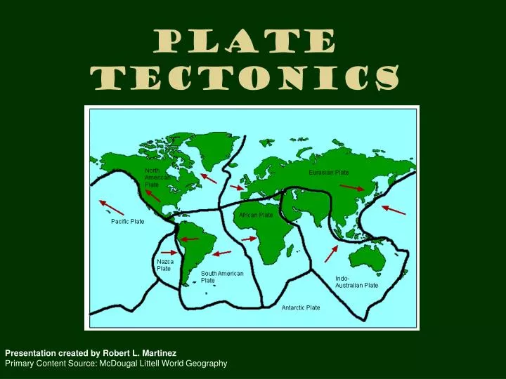
Plate Tectonics Presentation created by Robert L. Martinez Primary Content Source: McDougal Littell World Geography
The internal forces that shape the earth’s surface begin beneath the lithosphere.
Heated rock rises, moves up toward the lithosphere, cools, and circulates, downward.
Riding above this circulation system are the tectonic plates, enormous moving pieces of the earth’s lithosphere.
Geographers study the movement of the plates and the changes they cause in order to understand how the earth is continuously being reshaped…
Tectonic plates move in one of four ways 1) spreading, or moving apart; 2) subduction, or diving under another plate…
…3) collision, or crashing into one another; 4) sliding past each other in a shearing motion.
When tectonic plates come into contact, changes on the earth’s surface occur.
These types of boundaries mark plate movements: Divergent boundary, plates move apart, spreading horizontally.
Convergent boundary, plates collides, causing either one plate to dive under the other or the edges of both plates to crumble.
An example of divergent boundary is the one between Saudi Arabia and Egypt. The two plates on which those countries sit are spreading apart, making the Red Sea even wider.
The Red Sea is actually part of the Great Rift Valley in Africa.
An example of a convergent boundary can be found in South Asia.
The plate where India is located is crashing into the Asian continent and building up the Himalayas.
One of the most famous examples of a transform boundary is in North America, the San Andreas Fault in California.
When two plates meet each other, they can cause folding and cracking of the rock.
The transformation of the crust by folding or cracking occurs very slowly, a few centimeters or inches a year.
Because the movement is slow, the rocks, which are under great pressure, become more flexible and bend or fold, creating changes in the crust.
Sometimes the rock is not flexible and will crack under the pressures exerted by the plate movement.
This fracture in the earth’s crust is called a fault. It is at the fault line that the plates move past each other.
As the plates grind or slip past each other at a fault, the earth shakes or trembles.
This sometimes violent movement of the earth is an earthquake.
Thousands of earthquakes occur every year, but most are so slight that people cannot feel them.
A seismograph measures the size of the waves created by an earthquake.
The location in the earth where an earthquake begins is called the focus.
The point directly above the focus on the earth’s surface is the epicenter.
Nearly 95 percent of all recorded earthquakes occur around those boundaries.
Plate movement along the Pacific Rim and from southern Asia westward to southern Europe makes this region especially vulnerable to quakes.
Earthquakes result in squeezing, stretching, and shearing motions of the earth’s crust that damage land and structures.
The changes are most noticeable in places where people live.
Landslides, displacement of land, fires (from broken gas lines), and collapsed buildings are major outcomes of the ground motion.
Aftershocks, or smaller magnitude quakes, may occur after an initial shock and can sometimes continue for days afterward.
An earthquake is the sudden release of energy in the form of motion.
C.F. Richter developed a scale to measure the amount of energy released.
The Richter Scale uses information collected by seismographs to determine the relative strength of an earthquake.
The scale has no absolute upper limit. Most people would not notice a quake that measured 2 on the scale.
The largest quake ever measured was 8.9 in the Kermadec Islands of the South Pacific in 1986.
Sometimes an earthquake causes a tsunami, a giant wave in the ocean.
A tsunami can travel from the epicenter of a quake at speeds of up to 450 miles per hour, producing waves of 50 to 100 feet or higher.
The world record for a tsunami was set in 1971 off the Ryukyu Islands near Japan, where the wall of water reached 238 feet, more than 20 stories high.
Tsunamis may travel across wide stretches of the ocean and do damage on distant shores.
For example, in 1960 a quake near Chile created a tsunami that caused damage in Japan, almost half a world away.
A tsunami from a quake near Alaska killed 159 people in Hilo, Hawaii, in 1946.