Download
1 / 20
260 likes | 555 Views
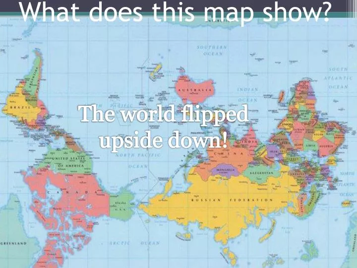
What does this map show?. The world flipped upside down!. What does this map show?. The world’s population density. 0:31. 0:59. 0:58. 0:57. 0:56. 0:55. 0:54. 0:53. 0:52. 0:51. 0:50. 0:49. 0:48. End. 1:00. 0:47. 0:44. 0:43. 0:42. 0:41. 0:40. 0:39. 0:38. 0:37. 0:36. 0:35.

E N D
What does this map show? The world flipped upside down!
What does this map show? The world’s population density
0:31 0:59 0:58 0:57 0:56 0:55 0:54 0:53 0:52 0:51 0:50 0:49 0:48 End 1:00 0:47 0:44 0:43 0:42 0:41 0:40 0:39 0:38 0:37 0:36 0:35 0:34 0:33 0:46 0:45 0:32 1:00 0:30 0:28 0:27 0:26 0:25 0:24 0:23 0:22 0:21 0:20 0:19 0:18 0:17 0:16 0:29 0:15 0:13 0:12 0:11 0:10 0:09 0:08 0:07 0:06 0:05 0:04 0:03 0:02 0:01 0:14 Quick Write! • Make a list of all the words you associate with maps.
Objective • Students will design a map of an imaginary country that they create with a partner • Students will identify and include important terms on their maps related to map skills
Map Skills Five Themes of Geography & Important Terms
Map A graphic representation of selected characteristics of a place, usually drawn to scale on a flat surface.
The Five Themes of Geography • When geographers work, they are guided by two basic questions: • Where are things located? • Why are they there? To find these answers, geographers use five themes to organize information
The Five Themes Of Geography • 1. Location • Absolute Location • Latitude • Parallel to the Equator • Longitude • Parallel to the Prime Meridian • Relative Location • 2. Place • Characteristics • 3. Human-Environment Interactions • Relationships within places
Five Themes Continued… • 4. Movement • Communication • Transportation • Settlement and Migration Patterns • 5. Regions • Ex: Middle East, Midwest
Types of Maps • Political Maps • showing the country capital and large cities, states, or counties • Physical Maps • showing the wide range of landforms in the country • Color Key Maps • showing average temperature, population density, elevations • Natural Resources Maps • showing locations of centers of agriculture, manufacturing, education
What does this map illustrate? Political map- shows boundaries/borders of countries (man-made)
What does this map illustrate? Physical map- shows geographic features such as mountains, lakes, deserts etc.
Types of Landforms 0:59 0:58 0:57 0:56 0:55 0:54 0:53 0:52 0:51 0:50 0:49 0:32 0:48 1:00 0:46 0:35 0:36 0:37 0:47 0:39 0:38 0:41 0:42 0:43 0:44 0:45 0:40 1:00 0:34 0:33 0:31 0:15 0:27 0:26 0:25 0:24 0:23 0:22 0:21 0:20 0:19 0:18 0:17 0:16 End 0:28 0:14 0:12 0:11 0:10 0:09 0:08 0:07 0:06 0:05 0:04 0:03 0:02 0:01 0:30 0:13 0:29 • Types of landforms? • Bay • Canal • Canyon • Dam • Desert • Forest • Grassland • Highland • Hill • Isthmus • Lake • Mountain • Peninsula • River • Savannah • Strait • Volcano • Waterfall • Woodlands
Key Elements- DOGSTAILS • Date • When the map was made • Orientation • Directions • Compass • Grid • Locates places on the map • Scale • What the map distance is • Title • What, where, and when • Author • Who made the map • Index • Map address of places • Legend • What the symbols mean • Sources • Basis for map information
Title, Date, & Author • Title • Identifies what is happening, where, and when. • Date • Text identifying when the map was made and/or updated. • Author • Text identifying the cartographer or organization responsible for making the map.
Orientation • Orientation: • A north arrow is a symbol indicating the direction in which north lies • A compass rose is a symbol indicating the cardinal directions • N, S, E,W • NE, NW, SE, SW
Grid • Grid • Intersecting lines, “coordinate system” drawn on a map to pinpoint location. • Often latitudes and longitudes
Scale • The relationship between distance on a map and actual distance on the earth. • A map showing a small area in detail is a “large scale” map • Amap showing a large area without much detail is a “small scale” map
Legend • Legend or Key • A guide identifying what the map’s symbols and colors represent.
1:01 1:33 2:00 1:59 1:58 1:57 1:56 1:55 1:54 1:53 1:52 1:51 1:50 1:49 1:48 1:47 1:46 1:45 1:44 1:43 1:42 1:41 1:40 1:39 1:38 1:37 1:36 1:35 End 1:34 1:32 1:03 1:16 1:29 1:28 1:27 1:26 1:25 1:24 1:23 1:22 1:21 1:20 1:19 1:18 1:17 1:15 1:31 1:14 1:13 1:12 1:11 1:10 1:09 1:08 1:07 1:06 1:05 1:04 1:30 1:02 2:00 1:00 0:58 0:57 0:56 0:55 0:54 0:53 0:52 0:51 0:50 0:49 0:48 0:47 0:46 0:45 0:44 0:43 0:42 0:41 0:40 0:39 0:38 0:37 0:36 0:35 0:34 0:33 0:32 0:31 0:59 0:30 0:28 0:29 0:27 0:26 0:25 0:24 0:23 0:22 0:21 0:20 0:19 0:18 0:17 0:16 0:15 0:13 0:12 0:11 0:10 0:09 0:08 0:07 0:06 0:05 0:04 0:03 0:02 0:01 0:14 Now find your partner! • You were each given a card with either a term or definition on it. You have 2 minutes to find your matching pairand be seated. • If you have a term they will have the definition it goes with. • If you have a definition they will have the term it goes with. • Together you will create an imaginary country • Use create a country worksheet as a guideline.