Download
1 / 22
220 likes | 232 Views
This article explores the potential benefits of a digital waterway network, including features, functionality, and its impact on intermodal connections and voyage planning. It also discusses the production and provision of the RIS Index and its intersection with INSPIRE. The article concludes with the advantages of digital waterway services.

E N D
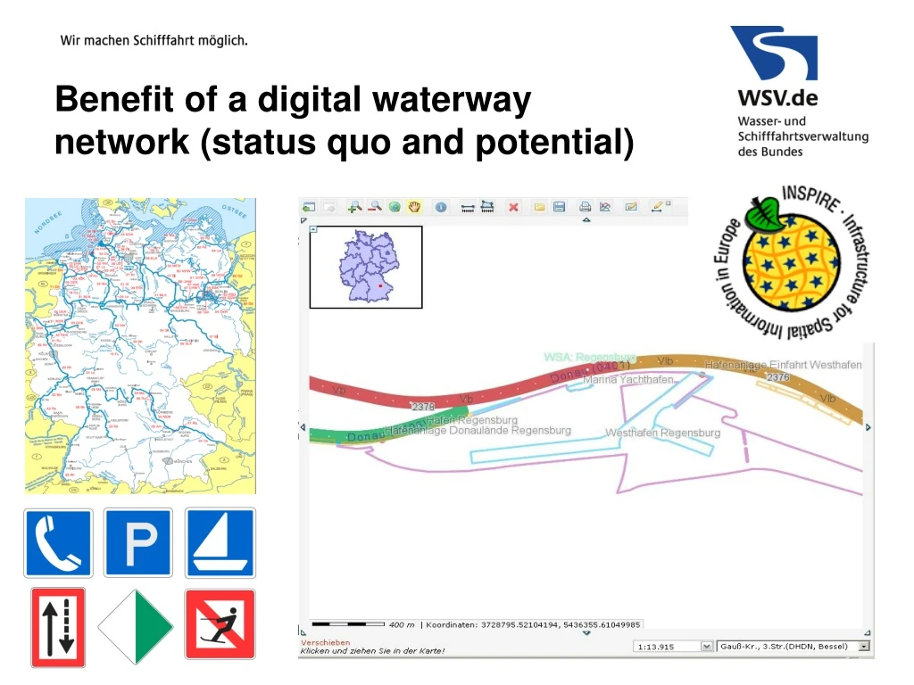
Benefit of a digital waterway network (status quo and potential)
Benefit of a digital waterway network • Content: • Dataset and Features • Digital waterway network, for instance in Germany • Functionality (realized) • Combined Web Map Services (WMS) • Waterway Locator (Web Feature Service (WFS)) • Functionality (planned) • RIS Index and ISRS location code • How to produce? • How to provide? • Intersection to INSPIRE • Fulfilling the INPIRE demands (Intermodal connections) • Routing (voyage planning) Conclusion (Benefit of a digital European waterway network)
Benefit of a digital waterway network Digital waterway network in Germany Main stretch (0401) and local branches along the Danube
Benefit of a digital waterway network Digital waterway network in Germany Connection points
Benefit of a digital waterway network Digital waterway network in Germany
Benefit of a digital waterway network Realized content • Basic geometry : • 100 m distance marks • Main stretch, branches, connection points (nodes) • Object relevant waterway kilometer • Attributes: • Waterway name, waterway ID • Waterway class • Responsibility • DESTATIS – harbours • National tables (VV-WSV 11 03): • … • …
Benefit of a digital waterway network Realized functionality Combined Web Map Services (WMS)
Benefit of a digital waterway network Realized functionality Waterway locator (WFS) • Waterway km => Coordinates • Coordinates => Waterway km
Benefit of a digital waterway network Realized functionality Waterway locator (WFS) • Map link generator
ISRS (Inland Ship Reporting Standard (UNECE)) UN country and location code RIS (River Information Services) National standards (e.g. national waterway ID’s) RIS Index Benefit of a digital waterway network RIS Index, missing link between standards INSPIRE e.g. intermodal traffic network
VTT (Vessel Tracking and Tracing) ERI (Electronic ship Reporting system) IENC (Inland ECDIS Navigational Charts) RIS Index NtS (Notices to Skippers) Benefit of a digital waterway network RIS Index, also a missing link between RIS services
“Joint Task Force on RIS Index”RIS Index Encoding Guide A reference book and user guide for the production of the RIS Index. ISRS location code Coordinates and additional attributes RIS Index Benefit of a digital waterway network RIS Index, how to produce? The RIS Index is a discrete redundant dataset, consisting of: • a 20 character object identifier (ISRS location code) for all objects, defined in the RIS Index Encoding Guide • additional data (point coordinates and attributes), taken from corresponding Inland ECDIS objects.
Benefit of a digital waterway network RIS Index, how to produce the ISRS location code? The location code (ISRS location code) which is defined in the International Ship Reporting System (ISRS) is used as object identifier. This is a 20 digit string which is put together by the following sub elements (mandatory fields): • UN country code (2 characters) ok (DE) • UN location code (3 characters) ? (WFS, waterway locator) • Fairway section code (5 characters) ok (WFS, waterway locator) • Object reference code (5 characters) (ok) (taken from IENC objects) • Fairway section hectometre (5 characters) ok (WFS, waterway locator)
Benefit of a digital waterway network RIS Index, ISRS location code out of waterway network Source: http://upload.wikimedia.org/wikipedia/commons/9/9f/NUTS_3_regions_EU-27.svg • Location code is an independent code • Geometry (shapes) are available and can be integrated • Creation of a new ISRS location code can be supported by a function of the waterway network • RIS Index can also be integrated in the waterway network and provided by a WFS functionality • Basic functionality of WMS and WFS is already running • Problems: • In Germany only 50% are covered with codes • But in this case „xxx“ can be used temporarily
Benefit of a digital waterway network RIS Index, ISRS location code out of waterway network Acquisition of ISRS location code (WFS) to keep IENCs up to date Waterway locator UN location code
Benefit of a digital waterway network RIS Index, production and provision 1 • Production out of IENC and waterway network • Provision of RIS Index (ISRS location code) in IENC and waterway network 2 2 2 1 RIS Index
Benefit of a digital waterway network Intersecting set between RIS Index and INSPIRE (1 of 2)
Benefit of a digital waterway network Intersecting set between RIS Index and INSPIRE (2 of 2)
Benefit of a digital waterway network INSPIRE: intermodal connections (harbours, ports)
Benefit of a digital waterway network Other planned functionality Routing (beta version)
Digital waterway network services Conclusion • Benefit of digital waterway services: • Map visualization (via WMS) and data provision (via WFS) • always up to date, no use of out-dated files • services can be integrated in application software (www standard) • Calculations and functionality for a lot of administrative tasks • waterway km => coordinates • coordinates => waterway km • click to object => ISRS location code • click to objects => RIS Index • Fulfilling the INSPIRE demands • Routing (voyage planning) • … More cooperation between European countries will lead to more benefit for everyone.