Basic Components of a World Map
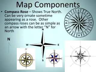
Basic Components of a World Map. Compass Rose. Compass rose tells direction on a map. 1. Cardinal Directions N north S south E east W west 2. Intermediate Directions NW northwest NE northeast SW southwest SE southeast.

Basic Components of a World Map
E N D
Presentation Transcript
Compass Rose • Compass rose tells direction on a map. 1. Cardinal Directions N north S south E east W west 2. Intermediate Directions NW northwest NE northeast SW southwest SE southeast
Look for a compass rose, or a north arrow. Usually North is at the top of the map.
Map KeyMap Legend Map Key explains symbols, lines, colors on a map.
Scale • A map’s scale compares the distance on a map to the distance in the real world. • Scale helps find the distance between two places. • There are large-scale maps and small-scale maps.
Hemispheres • Hemi- means "half" and sphere means "globe." • The earth is not really broken into halves, but there are imaginary lines used by people to divide the earth into different sections, called hemispheres. Just like with compass directions, these sections help to describe where you are on the earth.
Latitude-imaginary lines that run east and west around the earth. Equator- the beginning latitude line with a measurement of 0. Lines below the Equator are measured in degrees and said to be south of the Equator. Lines above the Equator are measured in degrees and said to be north of the Equator. The North Pole and the South Pole are the last latitude measurement. 90 degrees
Longitude- imaginary lines that run north and south around the earth. • Prime Meridian- the beginning longitude line with a measurement of 0.
Lines to the left of the Prime Meridian is measured in degrees and said to be west of the Prime Meridian. • Lines to the right of the Prime Meridian is measured in degrees and said to be east of the Prime Meridian. • The International Dateline is the last longitude line with a measurement of 180 degrees.l
Latitude and longitude lines are used to help locate specific places on the earth.
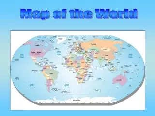
Oceans Arctic Pacific Atlantic Indian Southern
Continents North America South America Europe Asia Africa Australia Antarctica