Download
1 / 23
230 likes | 357 Views
This paper addresses the current transit challenges faced by Nanaimo's urban form, evaluates proposed enhancements, and identifies key obstacles such as political, financial, and density issues. It discusses the interconnectedness of street systems, referencing significant literature, including Condon's insights. The focus is on understanding local travel behaviors, modal splits, and the implications of urban design on transit efficiency. Attention is drawn to the importance of connectivity in urban planning, especially in light of the upcoming Nanaimo Global Film Festival highlighting activism.

E N D
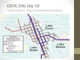
GEOG 346, Day 12 Condon: Chapter 3 – Design an Interconnected Street System
Housekeeping Items • I will return as many additional outlines as I have today. • There were a number of people who missed the mini-assignment last Thursday, so I will ask those people only to write a paper of four pages (including any map or chart) outlining 1)some of the challenges for transit of Nanaimo’s current urban form, 2) what, given the financial and in-built limitations, you would propose to do to enhance transit and its use by Nanaimo residents, and 3) what you envision as being the greatest obstacles and how would you characterize them (political, financial, low density, etc.). Due on Thursday, Feb. 20th. • The Nanaimo Global Film Festival is on February 14 and 15. The theme this year is Activism, and there are several films dealing with Fair Trade and similar issues. Full details, including the schedule, ticket info and trailers or writeups of each of the films, can be found on the website nanaimofilmfest.org.
FIGURES FROM 2001 ON MODAL SPLIT FOR THE TRIP TO WORK As background for our transit trip on Tuesday…
See also page 7 of https://www.nanaimo.ca/assets/Departments/Engineering~Public~Works/Transportation~Master~Plan/Household%20Travel%20Survey%20-%20Preliminary%20Results.pdf. And page 20 of https://www.nanaimo.ca/assets/Departments/Engineering~Public~Works/Transportation~Master~Plan/Nanaimo%20Existing%20Conditions%20Final%20Apr%202013.pdf. CHAPTER 3 of Condon is mostly devoted to the issue of the interconnectedness of street systems, the variety of such systems, and their benefits.
Recent RFP for Nanaimo Region The primary trip purposes of interest consist of (origin or destination trip purposes): • Work (including during) • Post-secondary school • Grade school • Dining/restaurant • Recreational/social • Shopping • Personal business (e.g. banking, doctor, etc.) • Go home (destination) • To pick-up • Drop-off or chauffeur, etc. Some of these trip purposes are "chained.“ Trip Mode A trip consists of the use of one or more travel modes. • Automobile driver • Automobile passenger • Truck driver • Transit bus (including route numbers) • handyDART • School bus • Other bus • Taxi/Airport shuttle • Bicycle / Roller blade • Walked part way • Walked all the way • Electric (motorized) wheelchairs • Other Trip Origin and Destination and Land Uses • House or apartment • Office building • Industrial • School • Daycare • Hospital or medical • Store, restaurant or theatre • Religious institution • Other services • Farm or vineyard • Indoor recreational (i.e. gym) • Outdoor recreational (i.e. park, beach, golf course) • Airport, long-distance bus depot, etc. • Ferry terminal
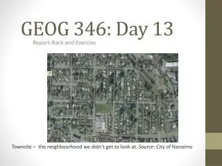
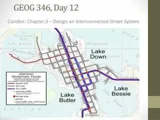
Here are three quite different neighbourhoods in Nanaimo in terms of street layout.
Lanes and Garages Upfront “Snout-fronted” houses • Old-fashioned neighbourhoods tend to have laneways whereas subdivisions usually don’t. Their benefits are said to include the following (these are cited by Condon as well): avoidance of ‘snout houses,’ avoidance of interference with pedestrians and on-street parking because of the number of driveways, and access for utilities and delivery vehicles. [See also www.cityofchicago.org/city/en/depts/cdot/provdrs/alley/svcs/green_alleys.html.] Source: Boston Globe.
Chapter 3 • p. 39- “Street systems either maximize connectivity or frustrate it.” • Condon claims that, prior to 1950, North American neighbour-hoods were rich in connectivity. Then the paradigm changed. Today over 60% of the urban landscape takes the form of a dendritic (or tree-like) street system.
Comparison of Street Layouts (Source: http://www.fhwa.dot.gov/publications/research/safety/pedbike/05085/chapt6.cfm)
Chapter 3 • Traditional grid patterns feature 2-3 different types of streets: streetcar arterials, residential streets, and sometimes laneways. • Dendritic systems have trunks (freeways or minor highways) major branches (major arterials), minor branches (collector streets), and residential streets and cul-de-sacs (twigs and tips). • What are the strengths and weaknesses of each of these road networks? • Condon, on pp. 41-42, lays out the difficulty of attempting to challenge in practice the still largely prevailing approach to road planning.
Source: http://www.fhwa.dot.gov/publications/ research/safety/pedbike/05085/chapt11.cfm Chapter 3 • One disadvantage of dendritic patterns is that people drive 40% more, produce 40% more GHGs, and possibly more households may often need an extra car. • It has been common practice to widen major intersections, as these tend to be chokepoints, and these became convenient for cars, but challenging for people with mobility issues.
Chapter 3 • The disparities can be seen in the following figures: per 100 million miles travelled, there are .75 fatalities for transit riders, 1.3 for drivers/ passengers, and 20.1 for pedestrians. • Suburban streets and arterials, especially, have less “side friction” than most traditional streets, with the result that cars are speeding faster. Pedestrian deaths are four times more common on wide suburban streets than urban arterials. A car travelling at 35 mph is ten times more likely to kill a pedestrian than one travelling at 25 mph. • What is side friction and what causes it? • He cites an example of Broadway Avenue in Vancouver: 4 through lanes, 2 parking lanes that become through lanes at rush hour, and no separate turning lanes (for the most part). It also has frequent lights and pedestrian crosswalks.
Chapter 3 • In Vancouver, streetcar arterials average about ½ a mile apart, which encourages people to walk to transit. • Even in traditional single-family urban neighbourhoods there is a lot of ‘hidden’ density that supports transit use – for instance, duplexes, secondary suites, and laneway units. He notes that densities are often as high as 17 units per gross acre (inclusive of streets), which is above the threshold for transit. • The curvy pattern and low densities of suburban neighbourhoods make them challenging for transit, not the least reason being that bus stops must often be far away from homes (see Figures 3.2 and 3.3 in the book).
Chapter 3 • Wide suburban streets are not only not safer for pedestrians, they have not shown any improvements in terms of fire safety and other forms of emergency response. What they gain in speed, they lose in directness (see the information on pp. 56-58).
Chapter 3 • In traditional urban neighbourhoods, unless there is advanced gentrifi-cation, the streetcar arterials will support smaller-scale retail, whereas in suburban environments retail tends to be dominated by chains and big-box stores that stake out major intersection and high traffic areas, in addition to destination malls and strip malls.
Chapter 3 • While cul-de-sacs are pleasant for those who live on them, typically only 25% of those living in a subdivision enjoy this pleasure. Suburban layouts also lend themselves to being gated communities. • Another trend in street design is the use of superblocks (40 acres or more in size). When poor neighbourhoods in NYC and elsewhere were bulldozed to create ‘housing projects,’ the streets were bulldozed along with them and replaced with super-blocks. These had some associated social problems. Do you know what they were?
Different Varieties of Grid • Condon talks about the different varieties of grids that are possible, including differences in block sizes. • Not only does he favour grid systems over dendritic, he is a fan of the Vancouver and Seattle system of blocks which are 640’ wide and 320’ deep, and which typically feature lots that are 33’ wide and 110’ deep (5 acres). Portland, by contrast, has blocks that 200’ on each side (<1 acre), and Manhattan has blocks that are long and skinny (900’ by 264’). • He feels that Vancouver blocks are adaptable to a variety of different land uses and building types (see pp. 52-53).
Taxicab geometry versus Euclidean distance: In taxicab geometry all three pictured lines (red, yellow, and blue) have the same length (12) for the same route. In Euclidean geometry, the green line has length 6×√2 ≈ 8.48, and is the unique shortest path. A one square km superblock sector in Milton Keynes framed by major roads on a grid configuration. The road network within the sector uses cul-de-sac streets complemented by bike and foot paths which connect the entire sector and beyond Source: Wikipedia
Street Patterns • p. 54- “No single feature of sustainable community design is more important than road width.” And, one might add, street pattern. It affects how much people drive and how much GHGs they emit. While suburbanites reduced kms. driven during the oil price spike, they did not decrease their automobile dependence. On the other hand, residents of traditional neighbourhoods actually took transit considerably more. • Nonetheless, despite this, there is considerable resistance from developers because of loss of developable land and added cost. In the past, developers were required to extend the existing grid when developing greenfield sites. Today, they are tasked with creating their own internal road network adjacent to the nearest arterial, though there may be guidelines. • Nonetheless, alternative standards and traffic calming are making inroads. For examples of many different approaches taken in Vancouver, see http://www.cremtl.qc.ca/fichiers-cre/files/TrafficCalminginVancouver.pdf.
Street Patterns • p. 65 – “Of all the challenges presented in this book, getting the street system right may be the most daunting.” Given that dendritic patterns are so prevalent, how do we change those or adapt them? Will future subdivision dwellers be “stuck up a cul-de-sac in a cement SUV,” as James Howard Kunstler suggests? • One tool at our disposable is software that helps people to envision how their streets can be transformed into something much more pleasant. Distributed by the Sierra Club, “Community Transformations” uses a sophisticated form of Photoshop to create before and after pictures – see http://www.sierraclub.org/sprawl/community/transformations/14thst.asp.