Download
1 / 29
310 likes | 506 Views
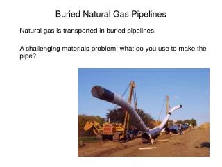
Engineering Geology for Gas Pipelines in the Green River Area. Prepared By: John Blair Sean Donahue Celeste Hoffman Kimberly Klinkers Megan Slater. Green River Basin Location. Green River Basin Stratigraphic Correlation Chart showing Study Map Units.

E N D
Engineering Geology for Gas Pipelines in the Green River Area Prepared By: John Blair Sean Donahue Celeste Hoffman Kimberly Klinkers Megan Slater
Green River Basin Stratigraphic Correlation Chart showing Study Map Units
Pipeline Installation Process • Clearing and grading • Stringing pipes along right of way • Excavating/trenching • Pipe bending, welding, and coating • Lower Pipe into trench • Back fill • Restoration
Geologic Hazards • Geologic Hazards are natural physical conditions that exist and if they were to become active could damage structures as well as injure people. These hazards include. • Fault Crossings • Subsidence • Slope stability • Hydrogeology • Environmental Constraints
What is the importance? • Safety of the general public. • Pipelines stay safe and operational. • Pipeline failure is a serious environmental concern.
Region • The area is composed of several faults. • Most of the Mountain Ranges were formed in the Eocene Era • Green River Basin is surrounded on all sides by mountains. • Wind River Mountains-North • Front Range, Park Range and Sawatch Range of Rockies -East • San Juan Volcanic Field-South • Wasatch Mountains-West
Pipelines and Fault Crossings • Due to the numerous active faults and numerous pipelines, several of these intersect. • This provides potential breaking of pipelines due to movement of faults
Construction of Pipelines • To protect from this, all pipelines are built of steel and treated with a protective coating. • The pipeline is carefully inspected to make sure it meets all safety requirements. • In fault zones pipes are padded with fill material to dampen vibrations and minimize damage.
Safety Considerations • If there is a break in the line, a high-tech computer monitoring system can detect a loss in pressure due to a leak and shut off all access to the length of pipe where a leak is detected. This system is monitored 24 hours a day 7 days a week • Inspections occur in the pipelines through camera inspections
Subsidence • Subsidence is the downward motion of the earths surface relative to a datum. Causes of subsidence: • Mining induced from “caving” in of excavated material • Dissolution of Limestone • Extraction of Natural Gas • Groundwater changes
Subsidence Damage • Subsidence causes a loss of support for the pipeline. • Damage may inhibit the functionality of the pipeline as a result of Structural damage.
Slope Stability Issues-Landslides • Landslides according the USGS are the upward and downward movement of earth materials on a slope. • Causes of Landslide include: • Steep Slopes • Wildfires • Earthquakes • Hydrological Events • Human causes • End Result • Loss of Foundation Support
Landslides-Steep Slopes • Steep slopes constrain where a pipeline line can be placed cost effectively. • Slopes greater than 30 degrees are highly susceptible to failure. • Erosion becomes a significant issue
Landslides • Wildfires • Prevalent in the Green River Basin • De-vegetates the slope, which in turn reduces stability • Earthquakes • Soil liquefaction due to shaking of ground • Cohesion less soils are prone to liquefaction as well as soils the are unconsolidated.
Landslides • Hydrologic Events • Heavy precipitation • Flooding • Human caused • Clearing and grading before pipeline installation • Blasting when bedrock is present
Wyoming Climate • 5th driest state • 2nd highest state • Mountains • Provide majority of surface water • Snow and runoff • Deserts and plains • House groundwater • Aquifers recharged from surface water
Groundwater Resources • Unconsolidated deposits • Alluvial deposits • Eolian sand/silt deposits • Glacial deposits • Lacustrine deposits • Bedrock formations • Sandstone • Limestone • Results in aquifer development “Water-saturated portion of an unconsolidated deposit or geologic bedrock formation which may yield usable quantities and qualities of groundwater through springs and/or wells”
Groundwater Resources • Water wells withdraw groundwater from aquifers to • Monitor water levels and water quality • Discharge through alluvial deposits and bedrock formations • Springs naturally withdraw groundwater from saturated aquifers
Environmental Constraints Weather: • Heavy rainfall and snowmelt paired with limited drainage of the valley can cause flash flood conditions • Snowstorms are frequent from November through May • Wind frequently follows snowfall • Wind can cause extreme cases of drift • High winds and the low temperature of the valley can cause blizzard or near blizzard conditions • Destructive hailstorms occasionally pass over the valley
Environmental Constraints Temperature Concerns: • Winters are Long and Cold • Low overnight temperatures due to cold air collection in the valley can cause freezing issues • Valley temperatures can be considerably lower than surrounding mountainsides • Often valley temperatures are well below zero in the winter months
Environmental Constraints Impacts of the Environment: • Snow, rain and hail all have an effect on slope stability in the valley region • High wind storms and hail storms can damage above ground piping • Low temperatures can cause freezing of the groundwater causing additional stresses on buried pipes
Environmental Constraints Impacts ON the Environment: • Pipe ruptures leak gas • If ruptures flare (left) they can cause a great deal of damage to the surroundings • This also produces a lot of air pollution from the smoke • This can be very dangerous to both humans and animals alike • The excavation required for drilling and laying pipelines is very disruptive to the environment • Animal habitats can be damaged • Construction pollutes area • Soil and slope conditions are changed
References • http://www.dom.com/about/gas-transmission/covepoint/expansion/construction.jsp • http://www.wsgs.uwyo.edu/surficial/ • http://3dparks.wr.usgs.gov/landslide/types.htm • http://www.esa.int/esaCP/SEMX4QVLWFE_index_1.html • http://www.fieldmuseum.org/expeditions/lance/map.html • http://skytruth.mediatools.org/gallery/270 • http://www.wrds.uwyo.edu/sco/climate/wyoclimate.html • http://www.wsgs.uwyo.edu/hydrology/ • http://www.canadiandiscovery.com/PDF/Green-River-Basin.pdf • http://waterplan.state.wy.us/plan/green/techmemos/gwdeterm.html • http://en.wikipedia.org/wiki/Green_River_Formation • http://www.geology.wisc.edu/~unstable/Sedimentary/Green_River_Basin.jpg