Download
1 / 28
280 likes | 349 Views
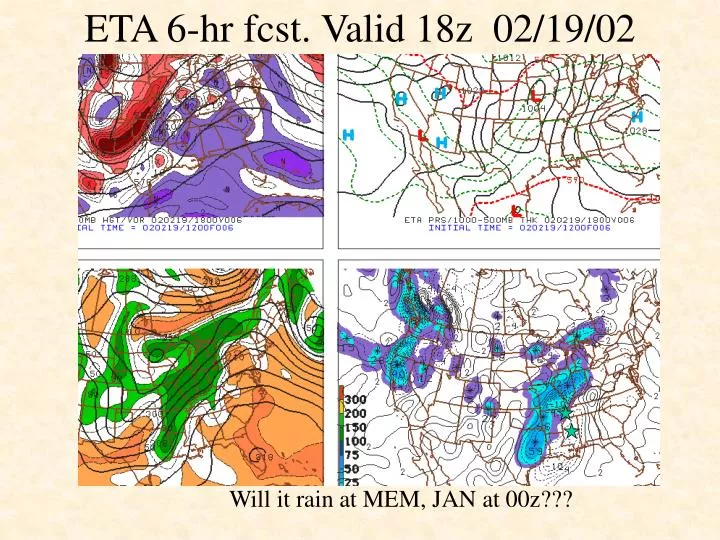
ETA 6-hr fcst. Valid 18z 02/19/02. Will it rain at MEM, JAN at 00z???. Association: Radar to 700 RH PRECIP FORECASTING. Radar: 18z. 6-hr ETA 700mb RH fcst: 18z. Short-term model output. Observations. Association: Radar to 700 RH PRECIP FORECASTING. 6-hr ETA 700mb RH fcst: 18z.

E N D
ETA 6-hr fcst. Valid 18z 02/19/02 Will it rain at MEM, JAN at 00z???
Association: Radar to 700 RHPRECIP FORECASTING Radar: 18z 6-hr ETA 700mb RH fcst: 18z Short-term model output Observations
Association: Radar to 700 RHPRECIP FORECASTING 6-hr ETA 700mb RH fcst: 18z 12-hr ETA 700mb RH fcst: 00z * * Raining in Memphis,TN? Jackson, MS? at 00z
Association: Radar to 700 RHPRECIP FORECASTING 24-hr ETA 700mb RH fcst. Valid 12z the next day A B Which location is more likely to be raining at this time?
Association: Cloud Forecasting * * What’s the sky look like in ALB? What’s the sky look like in n.MS?
Association: Satellite to 700 RHCLOUD FORECASTING 6-hr ETA 700mb RH fcst: 18z Correlation between cloud cover and 700mb RH ……
Temperature Forecasting • What causes temperature to change? DT/dt = • Advection • Diabatic effects • Radiative heating/cooling • Condensational heating/cooling • Adiabatic effects • Compressional warming (Descent) • Expansional cooling (Ascent)
Temperature Forecasting 850 mb method Adding 13.5C to 850mb temp = dry rate to 1000mb
Temperature Forecasting: 850mb method • Would this method work the same for all seasons? • Add less during cold season • Add more during warm season • Would this method work the same for all weather conditions? • Add less on cloudy, rainy days • Add more on bright, sunny days
Temperature Forecasting: 850mb method • General Rules of Thumb • In summer: • If mainly sunny -> 15/16C (13C-18C) • If cloudy -> 10C (6C-13C) • In winter: • If mainly sunny -> 11C (9C-13C) • If cloudy -> 4C (-2C-7C)
Temperature Forecasting Methods • Persistence • No change • Modified Persistence • Persistence (1st guess) + any changes • Advective changes? • Warm or Cold Advection? • Adiabatic changes? • Upslope vs downslope? • Diabatic changes? • More sun or less sun?
Temperature Forecasting Methods: Modified Persistence (850mb temp) Let’s predict Chicago’s max temp today! 18z Yesterday 18z Today What’s the predicted 850mb temp at 18z today? What was the 850mb temp 18z yesterday? 14C 20C What was Chicago’s high yesterday? Our prediction: 28C+6C=34C=93F KORD 292356Z 10SM FEW200 24/14 A2996 10278 20239
The ‘Delta Method’ • Modified persistence technique • Used in T, Td, winds forecasts • Correlates model tabular output to observed conditions
The ‘Delta Method’: Temperature Forecasting Raw Model Output (tabular data) 71F -> Highest 2m temp on the 5th: Change=? 77F -> Highest 2m temp on the 6th: -> Average 850mb temp on the 5th: 12C Change=? -> Average 850mb temp on the 6th: 17C
The ‘Delta Method’: Temperature Forecasting PIT Observations PIT High on the 5th: 23.9C=75F Predicted High on the 6th (DELTA 2m): 75F+6F=81F Predicted High on the 6th (DELTA 850mb): 75F+9F=84F
DELTA METHOD works best when: • TEMPERATURE • Radiative character (DAY 1) = radiative character (DAY 2) • Cloud cover between days is similar • Low lvl winds (DAY 1) = low lvl winds (DAY 2) • Especially true near coast, mountains …WHY? • Can work well in FROPA situations!
ETA 6 hr Forecast: Valid 18z 9/5/01 m415 web page- http://www.meteo.psu.edu/~m415mgr
ETA 30hr Forecast: Valid 18z 9/6/01 Is the radiative AND wind character similar?
Dew Point Forecasting • What causes dew point to change? dTd/dt = • Advection • Evaporation/Condensation • Adiabatic effects • ADVECTION is the dominant term
The ‘Delta Method’: Dew Point Forecasting -> 18z 2m Dew Point on the 4th: 69F Change= -14F -> 18z 2m Dew Point on the5th: 55F
The ‘Delta Method’: Dew Point Forecasting SEPTEMBER 4, 2001 MDT’s Dew Point 18z on Sept. 4th? 70F MDT’s Dew Point on Sept. 5th?
The ‘Delta Method’: Wind Forecasting CASE EXAMPLE: DDC SUSTAINED WIND: 10m method SUSTAINED WIND: 850 method -> Highest Wind on the 5th: 13 kts -> Highest Wind on the 5th: 17 kts -> Highest Wind on the6th: 19 kts -> Highest Wind on the6th: 28 kts
The ‘Delta Method’: Wind Forecasting CASE EXAMPLE: DDC Maximum Sustained Wind: Maximum Sustained Wind: 15kts 15kts Forecast for 9/6: 17+11=29kts Forecast for 9/6: 15+6=21kts
DELTA METHOD (WINDS) works best when: • Low-level stability of period 1 = low-level stability of period 2 ! • In unstable/well-mixed environments, consider using 850mb for the Delta method!