Download

1 / 17
170 likes | 196 Views
Explore the cutting-edge research on high-performance geographic information systems for real-time battlefield simulation and analysis. Discover advanced technologies and methodologies enhancing military decision-making processes.

E N D
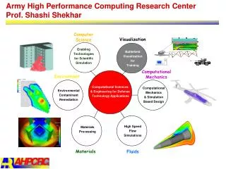
Army High Performance Computing Research CenterProf. Shashi Shekhar ComputerScience Visualization Enabling Technologies for Scientific Simulation Battlefield Visualization for Training ComputationalMechanics Environment Computational Sciences & Engineering for Defense Technology Applications Computational Mechanics & Simulation Based Design Environmental Contaminant Remediation High Speed Flow Simulations Materials Processing Materials Fluids
Prof. Shashi Shekhar AHPCRC/Dept. of Computer Science, University of Minnesota Research Interests • High Performance Geographic Information Systems (HPGIS) • Spatial Databases • Indexing, Clustering, Storage methods • Query Processing and Optimization • Terrain Visualization Maps Battlefield Events Surveillance Data Soldiers Situation Assessment HPGIS Battlefield Simulation
Maps are as important to soldiers as guns Soldiers Surveillance Data HPGIS Battlefield Events Situation Assessment Maps Battlefield Simulation • Example Usage of Geographic Info. Systems (GIS) in Battlefield : • Rescue of pilots after their planes went down (recently in Kosovo) • Precision targeting e.g. avoid accidental bombing of friendly embassies • Logistics of Troop movements, avoid friendly fires
GIS Analysis by Army • Tactical: (1) Navigate in unfamiliar terrain, (2) Avoid friendly fire, (3) Given recent firing patterns, locate hidden enemy units. • Operational: (1) Corridor Analysis: Identify sequence of land parcels suitable for troop movement for given unit size and vehicle types ? (2) Simulate enemy terrain for training in a flight simulator. • Strategic:Which Army Base locations are most critical given strategic interests, local demographic/political conditions ?
Set of Polygons Set of Polygons Local Terrain Database Remote Terrain Databases Graphics Engine Display 2Hz. 8Km X 8Km Bounding Box 25 Km X 25 Km Bounding Box 30 Hz. View Graphics High Performance GIS Component Parallelizing Range Queries for Battlefield Simulation • (1/30) second Response time constraint on Range Query • Parallel processing necessary since best sequential computer cannot meet requirement • Green rectangle = a range query, Polygon colors shows processor assignment
Declustering and Load-Balancing Methods to Parallelize GISS. Shekhar, S. Ravada, V. Kumar (University of Minnesota), D. Chubb, G. Turner (US Army) Research Objective: Meet the response time constraint for real time battlefield terrain visualization in flight simulator. Methodology: Data-partitioning approach Evaluation on Cray T3D, SGI Challenge. Results: Data replication needed for dynamic load-balancing, as local processing is cheaper than data transfer Good de-clustering method needed for dynamic load-balancing Significance: A major improvement in capability of geographic information systems for determining the subset of terrain polygons within the view point (Range Query) of a soldier in a flight simulator using real geographic terrain data set. Dividing a Map among 4 processors. Polygons within a processor have common color
BattleField Assesment: A Database Querying Approach S. Shekhar, X. Liu and S.Chawla(U. of M), Dr. J. Gurney, Dr. E. Klipple (ARL Adelphi) Research Objective: Design of spatial database query language for Battlefield decision support system. Methodology: • Object model for directions. E.g., North, Between, Left, 3 O’ Clock. • Integrate directional data-types in industry-standard query language (SQL) and Spatial Library(OGIS). Results: • An algebra(value-domain, operators) for direction objects. • Integration of algebra in commercial object-relational databases. Significance: A major step towards simple “natural language” like query interface for battlefield decision support systems. Query: List the farm fields to the left of the lake which are suitable for tank movement ? SELECT F.name, F.extent FROM FarmField F, Lake L,Viewer V WHERE V.left (F.extent, L.extent) AND L.name = ‘Beech Lake’ AND F.soil-firmness > 5; Note: Leftis a viewer-based “direction” predicate.
Orientation-based Direction Query Processing • Classical Strategies • Based on Range query strategy • Limitations • May lead to large unnecessary I/O and CPU cost • Need to know world boundary and calculate the intersection of boundary and direction region • Post Filter step is needed even for MBR objects • Our approach • Open shape based strategy(OSS)
Open Shape based Strategy(OSS) • Basic idea • Model direction region as an open shape • Use actual direction region as a filter • Advantages • Improve filtering efficiency by eliminating false hits • Reduce unnecessary I/O and CPU cost • Eliminate post Filter step for MBR objects • Do not need to have knowledge of world boundary • Experimental evaluations • Consistently outperforms classical range query strategy both in I/O and CPU.
Extension Period • Open Shape Strategy for Directional Query processing • Join Index Data Structure • Spatial Data Mining • Workshop: Battlefield Visualization and Real Time GIS.
Spatial Data Mining(SDM) • Historical Example: London Asiatic Cholera(Griffith) • Search of implicit, interesting patterns embedded in geo-spatial databases • Reconnaissance • Vector maps(NIMA, TEC) • GPS • Data Mining vs. Statistics: High utility local trends • SDM vs. DM: Spatial Autocorrelation
Army Relevance of SDM • A decision aid in establishing the next service center • location, location, location • Detection of lost ammunition dumps at civil war battlegrounds (Dr. Radhakrishnan) • Search for local trends in massive simulation data stored in Army lab databases • Army/DoD is one of the biggest landowners. • pristine environment, home to endangered species • balance unique defense requirements(training and war games) with environmental regulations
Spatial Data Mining: Case Study of location Prediction Given: 1. Spatial Framework 2. Explanatory functions: 3. A dependent function 4. A family of function mappings: Find: A function Objective:maximize classification_accuracy Constraints: Spatial Autocorrelation exists Nest locations Distance to open water Water depth Vegetation durability
SDM Evaluation: Changing Model • Linear Regression • Spatial Regression • Spatial model is better
SDM Evaluation: Changing measure New measure:
Accomplishments • Scaleable parallel methods for GIS Querying for Battlefield Visualization • A spatial data model for directions for querying battlefield information • Spatial data mining: Predicting Locations Using Maps Similarity (PLUMS) • An efficient indexing method, CCAM, for spatial graphs, e.g. Road Maps
Army Relevance and Collaborations Relevance: “Maps are as important to soldiers as guns” - unknown Joint Projects: High Performance GIS for Battlefield Simulation (ARL Adelphi) Spatial Querying for Battlefield Situation Assessment (ARL Adelphi) Joint Publications: w/ G. Turner (ARL Adelphi, MD) & D. Chubb (CECOM IEWD) IEEE Computer (December 1996) IEEE Transactions on Knowledge and Data Eng. (July-Aug. 1998) Three conference papers Visits, Other Collaborations GIS group, Waterways Experimentation Station (Army) Concept Analysis Agency, Topographic Eng. Center, ARL, Adelphi Workshop on Battlefield Visualization and Real Time GIS (4/2000)