Download
1 / 1
10 likes | 118 Views
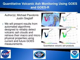
This poster summarizes ongoing efforts at NASA's Langley Research Center to develop cloud algorithms for the upcoming GOES-R satellite by leveraging data from the Meteosat-8 SEVIRI satellite. By calibrating SEVIRI data against MODIS, we ensure accurate cloud property retrievals despite the atmospheric complexity. We present initial analyses and comparisons with ground measurements in Europe and Africa, highlighting advancements in cloud detection and property retrievals. Future work aims to optimize these algorithms further and integrate additional channels to enhance cloud observation accuracy.

E N D
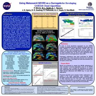
LaRC-SEVIRI Cloud Top LaRC-SEVIRI Cloud Base 0.65 µm Reflectance 1.6 µm Reflectance 3.7 µm Temp 6.7 µm Temp 10.8 µm Temp 12 or 13.3 µm Temp Broadband Albedo Broadband Infrared Cloud Mask Cloud Phase Pixel Latitude Pixel Longitude Optical Depth Effective Radius/Diameter Liquid/Ice Water Path Cloud Effective Temp Cloud Top Pressure Cloud Effective Pressure Cloud Bottom Pressure Cloud Top Height Cloud Effective Height Cloud Bottom Height Skin Temperature Infrared Emittance Using Meteosat-8 SEVIRI as a Surrogate for Developing GOES-R Cloud Algorithms P. Minnis, W. L. Smith Jr., L. Nguyen, J. K. Ayers, D. R. Doelling, R. Palikonda, Q. Z. Trepte, S. Sun-Mack NASA Langley Research Center LaRC-SEVIRI Comparisons with Data from Surface Sites Introduction ABI Channels vs. other Satellites Experience gained from years of applied cloud remote sensing techniques to GOES, MODIS, Meteosat and AVHRR data will be used to develop and test a set of ABI candidate cloud algorithms. Because the atmosphere is complex and does not necessarily match our theoretical understanding, the algorithms being developed should be applied to data that is as spectrally consistent to the ABI as possible. This poster provides a summary of efforts recently initiated to use Meteosat-8 SEVIRI data as a surrogate for GOES-R cloud algorithm development and the initial testing of current geostationary satellite cloud retrieval methods. The initial steps include calibration of the SEVIRI against their MODIS counterparts to ensure that model-based retrievals can be used confidently with the SEVIRI data. A set of algorithms currently being applied in real time to GOES-10/12 are used to analyze the SEVIRI data after calibration. The results of these analyses are presented along with initial comparisons to similar parameters derived from active remote sensing sites in Europe and Africa. Potential improvements making use of additional channels not available on current GOES imagers are discussed. Cabauw, Netherlands Radar Comparison (4/15/2006) Cabauw, Netherlands Radar Comparison (4/20/2006) LaRC-SEVIRI Cloud Top LaRC-SEVIRI Cloud Base Ceilometer Cloud Base Height Comparison Chilbolton, UK (January - March, 2006) Liquid Water Path Comparison (April 2005) MeanV = 3.58 MeanC = 3.50 Bias = -0.08 RMS = 0.96 RMS% = 27.3 Num = 100 Chilbolton, UK SEVIRI Cloud Analysis April 23, 2006 at 13:00 UTC MeanV = 129.97 MeanM = 130.73 Bias = 0.76 RMS = 82.49 RMS% = 63.10 RGB Image Cloud Phase LaRC-SEVIRI Cloud Base (km) LaRC-SEVIRI LWP (g/m**2) *Ceilometer data provided by the Radiocommunications Research Unit at the Rutherford Appleton Laboratory Optical Depth Ice Water Path Summary A suite of cloud algorithms developed for the CERES program and applied routinely to MODIS and GOES data have been adapted to analyze Meteosat-8 SEVIRI data. The analysis system being developed will prove valuable for testing and improving candidate ABI cloud algorithms such as those exploited here, as well as other algorithms being developed by the Cloud Applications Team (CAT). Preliminary calibrations have been performed for SEVIRI using MODIS data. Cloud parameters derived from calibrated SEVIRI data compare reasonably well with data obtained from European surface sites. Current SEVIRI Products Derived with NASA LaRC Algorithms Cloud Top Height Cloud Base Height SEVIRI Calibration Future Work SEVIRI 0.65 m with Aqua MODIS Efforts are proposed to expand the SEVIRI calibrations to other channels, to develop degradation rates for the SEVIRI solar channels, and to stratify the calibrations by surface type, augmented with theoretical adjustments to account for slight spectral differences with MODIS (e.g. 1.6 m), when appropriate. Proposed algorithm work includes further optimization and testing of the LaRC algorithms, more validation with European surface sites, theoretical studies, and incorporation of other channels (e.g. 8.7, 13.3 m). This should yield improved cloud detection and property retrievals, particularly in overlap conditions, at night, and near the terminator. Trend in GOES-10 visible channel calibration gain derived from GOES-8 &12 visible channels as calibrated against Terra MODIS. Taken from Nguyen et al. (2006). Pixel-level Product: Binary data retrieved at instrument nominal resolution. Used for matching with surface and aircraft measurements. Gridded Product: 0.5º or 1.0º average separated by cloud height or by phase. Surface Site Radii Product: Means of pixel-derived quantities within a 10 or 20km radius centered at surface sites. SEVIRI 1.6 m with Terra MODIS Trends in the SEVIRI calibration are being developed in a similar manner. Cloud Products Website http://www-pm.larc.nasa.gov Min, Q, P. Minnis, and M. M. Khaiyer, 2004: Comparison of cirrus optical depths from GOES-8 and surface measurements. J. Geophys. Res., 109, D20119, 10.1029/2003JD004390. Minnis, P., D. P. Garber, D. F. Young, R. F. Arduini, and Y. Takano, 1998: Parameterization of reflectance and effective emittance for satellite remote sensing of cloud properties. J. Atmos. Sci., 55, 3313-3339. Minnis, P., W. L. Smith, Jr., D. F. Young, L. Nguyen, A. D. Rapp, P. W. Heck, and M. M. Khaiyer, 2002: Near-real-time retrieval of cloud properties over the ARM CART area from GOES data. Proc. 12th ARM Science Team Meeting, April 8-12, St. Petersburg, FL, 7 pp. Minnis, P., L. Nguyen, W. L. Smith, Jr., J. J. Murray, R. Palikonda, M. M. Khaiyer, D. A. Spangenberg, P. W. Heck, and Q. Z. Trepte, 2005: Near real-time satellite cloud products for nowcasting applications. Proc. WWRP Symp. Nowcasting & Very Short Range Forecasting, Toulouse, France, 5-9 September, CD-ROM 4.19. References Chang, F.-L. and Z. Li, 2005: A new method for detection fo cirrus overlapping water clouds and determination of their optical properties. J. Atmos. Sci., 62, 3993-4009. Dong, X., P. Minnis, G. G. Mace, W. L. Smith, Jr., M. Poellot, R. T. Marchand, and A. D. Rapp, 2002: Comparison of stratus cloud properties deduced from surface, GOES, and aircraft data during the March 2000 ARM Cloud IOP. J. Atmos. Sci., 59, 3256-3284. Minnis, P., D. P. Kratz, J. A. Coakley, Jr., M. D. King, D. Garber, P. Heck, S. Mayor, D. F. Young, and R. Arduini, 1995: Cloud Optical Property Retrieval (Subsystem 4.3). "Clouds and the Earth's Radiant Energy System (CERES) Algorithm Theoretical Basis Document, Volume III: Cloud Analyses and Radiance Inversions (Subsystem 4)", NASA RP 1376 Vol. 3, edited by CERES Science Team, pp. 135-176. Acknowledgement This research is supported by the NOAA GOES-R Mission Office and the NASA Radiation Sciences Branch.