Download
1 / 6
60 likes | 182 Views
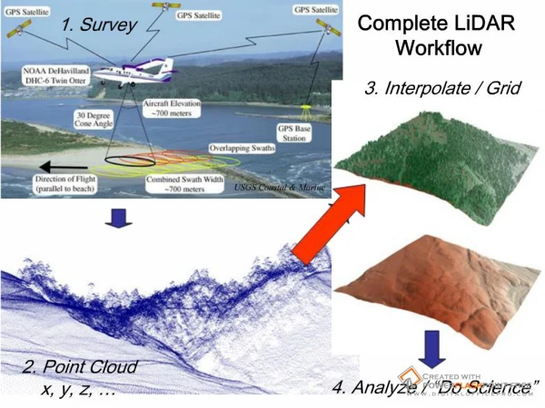
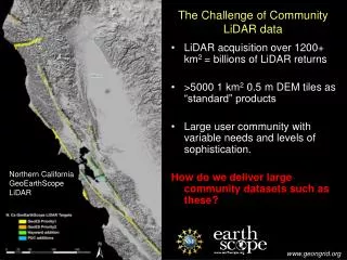
The Challenge of Community LiDAR data. LiDAR acquisition over 1200+ km 2 = billions of LiDAR returns >5000 1 km 2 0.5 m DEM tiles as “standard” products Large user community with variable needs and levels of sophistication. How do we deliver large community datasets such as these?.

E N D
The Challenge of Community LiDAR data • LiDAR acquisition over 1200+ km2 = billions of LiDAR returns • >5000 1 km2 0.5 m DEM tiles as “standard” products • Large user community with variable needs and levels of sophistication. How do we deliver large community datasets such as these? Northern California GeoEarthScope LiDAR
The Challenge of Community LiDAR data LiDAR coverage of the southern San Andreas and San Jacinto faults - ~ 3.7 billion LiDAR returns, ~1.9 TB - Very high-res., supports 25-50 cm DEMs
Delivery • Hard Disc or DVD • Files organized into tiles • Point cloud • Pre-computed DEMs • Organization typically kilometer tiles or USGS quarter quads • Naming convention hopefully meaningful
Files x,y,z,date,time,returnnumber,noreturns,offnidar,returnint,classification 6079558.34,2121999.58,69.06,1204,+1.39915067000000E+003,1,5,15.63,116,"G" 6079533.28,2122000.47,69.28,1204,+1.39915091000000E+003,1,5,15.18,114,"G" 6079507.99,2122001.37,69.11,1204,+1.39915115000000E+003,1,5,14.72,86,"G" 6079483.27,2122002.25,68.84,1204,+1.39915139000000E+003,1,5,14.27,84,"G" 6079555.62,2121995.47,68.74,1204,+1.39916953000000E+003,1,5,15.58,104,"G" 6079530.13,2121996.37,68.91,1204,+1.39916977000000E+003,1,5,15.12,132,"G" 6079505.12,2121997.26,68.86,1204,+1.39917001000000E+003,1,5,14.67,100,"G" 6079480.27,2121998.14,68.53,1204,+1.39917025000000E+003,1,5,14.21,77,"G" 6079455.95,2121999.00,68.28,1204,+1.39917049000000E+003,1,5,13.77,61,"G" 6079435.83,2121999.71,68.12,1204,+1.39917068000000E+003,1,5,13.40,62,"G" 6079411.33,2122000.58,68.05,1204,+1.39917092000000E+003,1,5,12.95,59,"G" 6079386.97,2122001.45,67.77,1204,+1.39917116000000E+003,1,5,12.50,55,"G“ x,y,z,gpstime,returnint,passid 407803.58,3818548.36,920.10,"502994.982638",117,"Str_169" 407804.28,3818549.45,919.99,"502994.982666",138,"Str_169" 407804.24,3818546.02,919.24,"502995.004870",137,"Str_169" 407805.35,3818547.70,918.94,"502995.004912",126,"Str_169" 407804.33,3818545.67,919.26,"502995.006956",104,"Str_169" 407803.68,3818541.47,919.28,"502995.027046",107,"Str_169"
Files, Cont. • LAS: Binary point cloud format • “industry standard” • Much smaller file sizes due to binary format • Requires specific tools to read or translate • Relatively uncommon in geoscience datasets
Files cont. Digital Elevation Models: • ESRI binary grids • Filtered and unfiltered • a.k.a. bare earth and full feature • Ascii grids (.asc) • Arc ascii • “standard” ascii